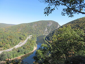
New Jersey has Mount Tammany and Pennsylvania has Mount Minsi, with the Delaware River passing through the gap between the two mountains. Mount Minsi is the high point above the Delaware River on the Pennsylvania aside, and even though it is basically a continuation of the Kittatiny mountain range found in New Jersey, in Pennsylvania they are called Blue Mountain. The geology appears to be the same, as well.
As with Tammany, the trails do not actually go to the mountain's summit. There are vistas along the way that provide enjoyable views of the river and Mount Tammany. However, the vistas on this side of the river are far fewer and much more restricted. Mostly, you will be hiking up the Appalachian Trail for its final miles in Pennsylvania, and in this area, it is like a tunnel through rhododendrons. This may be nice in spring when they flower, but most of the year it is very tight hiking. I would not want to hike this in summer with hot, humid stagnant air.
The hike is easy to locate. In the parking lot look for the signs at the SE side of the lot and follow the white AT blazes painted on the trees. You will follow the AT to the "summit". The true summit is around the radio tower, and there are also some pillars from a long-gone fire tower, I have read. Just past these features is the viewpoint where you may find others sitting. If you have done Tammany, you won't likely be impressed. Descend the way you came.
WARNING! Hiking and outdoor related sports can be dangerous. Be responsible and prepare for the trip. Study the area you are entering and plan accordingly. Dress for the current and unexpected weather changes. Take plenty of water. Never go alone. Make an itinerary with your plan(s), route(s), destination(s) and expected return time. Give your itinerary to trusted family and/or friends.
Permit $$
None
Directions
Road
Paved - Car Okay
To hike Take Interstate 80 West in New Jersey to the Delaware River and cross the river paying the toll. Exit at exit 310 for PA 611. PA 611 is also Foxtown Hill Road. After a short distance, you need to make a left to go south on Main St following PA 611. Turn right onto Mountain Road, and then take the left fork on Lake Road and follow that to the Trailhead Parking.
To avoid the toll, park in New Jersey at either of the other trailheads or the Water Gap visitor center and follow the Appalachian Trail over the I-80 bridge and continue to follow the AT to the trailhead.
page created by HAZ_Hikebot on Oct 07 2024 6:23 am
 Route Editor