Route Editor

| Guide | ♦ | 52 Triplogs | 1 Topic |
details | drive | no permit | forecast | 🔥 route |
stats |
photos | triplogs | topic | location |
| 561 | 52 | 1 |
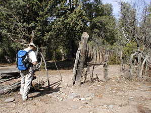
Gentle scenic mountain stroll by sidijoel   Overview OverviewThis is a very scenic 10-mile hike (5 miles out and back) with about 500 ft of elevation gain. There was no water available on this hike... all creeks and springs were dry in early November 2005. The daytime temperature was in the mid-'60s. There was good cell phone coverage at the trailhead and on the trail until about half way... at the Potato Patch. Summary The trail starts at the Wilderness Area sign post at the Mormon Grove Trailhead.
Continue along Saddle Mountain Trail another 1.4 miles (1.9 miles from the trailhead) of gentle rocky uphill till you get to a rock cairn. There are bluffs to your right. Back on the main trail, after the cairn, you continue around the bluffs and pass through a gate as you meander around the base of Saddle Mountain. Saddle Mountain is above you and to your left. The trail becomes narrower and rock-free hard pack and is precipitous to your right for a short while so take care. You pass the trail high point (about 500 ft above the start point) and gently drop about 200 ft until you reach the Trail Post marking the intersection of the Sheep Creek Trail and the Saddle Mountain Trail. (Note: At this trail intersection, The Saddle Mountain Trail shows continuing Northeast which will take you to the Old Story Mine site). Take the Sheep Creek Trail downhill to your left. You will enter a dry wash at the bottom and about 25 yds into the wash, the trail exits up and to the left. The trail is now narrow and more overgrown. You will climb a little and contour around the west side of McFarland Canyon for a short distance and then the trail drops sharply 300 ft down a series of dusty switchbacks into the canyon. Check out the mine entrance across the creek to your right as you near the bottom of the canyon. You will find the next Trail Post marking the intersection of the Sheep Creek Trail and Thicket Spring Trail at the bottom of the canyon. You are 4 miles from the trailhead. The mine entrance is just a short hop up the Thicket Spring Trail. Follow the Sheep Creek Trail alongside the creek bed. The trail may become less distinct because of leaves and pine needles. There are many cairns alongside the trail to mark the way. After about 1/2 mile you will reach a corral at Squaw Flat Spring. The spring comes up in a concrete water trough inside the corral... it was dry when we visited in early November. Walk through the corral and across the creek bed. The trail continues alongside the creek up a rocky lane until you reach the Trail Post marking the intersection of Sheep Creek Trail and Copper Camp Trail. Take Sheep Creek Trail uphill for a nice view back over the Matzatzals. You need to go no further than 1/4 to 1/2 mile up Sheep Creek Trail. The hike back to the trailhead is the reverse of the outward journey. Driving GPS Coordinates: - Start of FR201 (at old highway 87) - N33.55.869 W111.27.841 - FR25/FR25A Y in the road - N33.56.486 W111.28.978 Hiking GPS Coordinates: - Mormon Grove Trail Head - N33.56.357 W111.30.126, Elevation 4926 ft - 1st Trail Post (Saddle Mountain/Little Saddle Trail intersection) - N33.56.415 W111.30.535, Elevation 5029 ft - Cairn at Potato Patch - N33.57.150 and W111.30.958, Elevation 5480 ft - 2nd Trail Post (Sheep Creek Trail/Saddle Mountain Trail intersection) - N33.57.800 W111.30.487, Elevation 5297 ft - 3rd Trail Post (Sheep Creek Trail/Thicket Spring Trail intersection) - N33.58.140 W111.30.489, Elevation 4930 ft - 4th Trail Post (Sheep Creek Trail/Copper Camp Trail intersection) - N33.58.230 W111.31.252, Elevation 5141 ft Gate Policy: If a gate is closed upon arrival, leave it closed after you go through. If it is open, leave it open. Leaving a closed gate open may put cattle in danger. Closing an open gate may cut them off from water. Please be respectful, leave gates as found. The exception is signage on the gate directing you otherwise. Check out the Official Route and Triplogs. Leave No Trace and +Add a Triplog after your hike to support this local community. | |||||||||||||||||||||||||||||||||||||||||||||||||||||||||||||||||||||||||||||||||||||||||||||||||||||||||||||||||||||||||||||||||||||||||||||||||||||||||||||||||||||||||||||||||||||||||||||||||||||||||||||||||||