Route Editor

| Guide | ♦ | 800 Triplogs | 2 Topics |
details | drive | no permit | forecast | route |
stats |
photos | triplogs | topics | location |
| 304 | 800 | 2 |
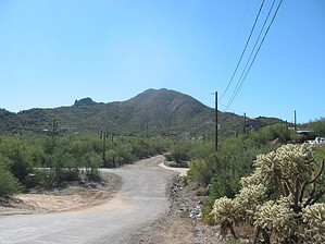
360 Degree Panoramic Views by Al_HikesAZ   2012-01-12 creekercouncil note 2012-01-12 creekercouncil noteThe description of the route up Black Mountain in Cave Creek suggests a route across private property without the permission of the landowner. Specifically, after the first 1/3 of a mile, the hiker should take the trail marked by the brown Town of Cave Creek signs. Walking up the road to the right (which is not marked by a sign) leads the hiker onto private property. The posted trail exists within the N-S Schoolhouse Road right of way dedicated by the Town of Cave Creek about 7 years ago. Unfortunately, many hikers ignore the marked trail and venture onto private property. That property contains 6-7 building lots that will be developed in the future. A cable blocking the private road has been vandalized. 2010-09-13 FedHiker note The trail is now clearly marked as you start uphill past the private drive. The jeep road route is a more steady grade and wider for jogging if you prefer. Both trails meet at a point about 1/3 of the way up.
This trail starts with two strikes but then redeems itself with good cardio conditioning and home-run panoramic views at the top. The first strike is the parking. There are approximately 10 parking spaces on the west side of School House Rd. north of the wash north of Military St. If you don't get one of these spaces, turn back to Cave Creek Road and find a space somewhere. This makes for a longer hike along a dirt street. The wash elevation is 2,195 feet and is the marked start of my description. The next strike against this trail is that from Military St. it proceeds south up a dirt road for 1/3 mile. If you are unlucky, you may be breathing some dust. With the development in the area, this road will probably be paved soon. At the 1/3 mile mark and 2,290 feet elevation, you hit a Y in the road. Take the right on the Y. The left of the Y goes to some very nice houses. The road turns into a jeep road. Great views to the North behind you. Great views will continue to the summit. At 1/2 mile the jeep road curves to the right passes a water tank and crests a saddle. Great views to the southwest. The road turns to the southeast. At 2/3 of a mile, the jeep road ends and the trail begins. Elevation 2,536. The trail shows signs of maintenance, but it is still primitive. At 3/4 of a mile, a trail joins from the east. This is apparently an alternate trail that avoids some of the jeep trail, but it is not the main trail so I won't elaborate. Stay to the right and keep heading uphill. The switchbacks are very tight so this is a straight uphill hike. At the 3/4 mile mark, you are at 2,675 feet. At the 1 mile mark, you are at 3,000 feet. Keep heading uphill. The trail becomes rockier. You won't need to use your hands to scramble, but you will have some high steps. At 1.25 miles you reach the summit and the trail redeems itself with 360-degree panoramic views. Enjoy! The final 3/4 mile to the top and the views redeem the dirt street and the parking. If you live near Black Mountain, this is a great training hike. If you don't live near Black Mountain, the mountains in the Phoenix Preserves are better. Check out the Official Route and Triplogs. Leave No Trace and +Add a Triplog after your hike to support this local community. | ||||||||||||||||||||||||||||||||||||||||||||||||||||||||||||||||||||||||||||||||||||||||