Route Editor

| Guide | ♦ | 2 Triplogs | 0 Topics |
details | drive | permit | forecast | route |
stats |
photos | triplogs | topics | location |
| 27 | 2 | 0 |
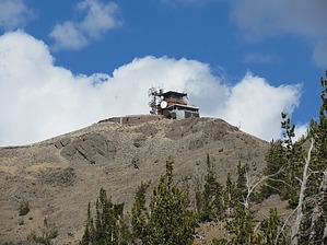
Mountaintop Room With A View by John10s Mt. Washburn (10,219') is a popular day hiking destination in north-central Yellowstone that offers panoramic views and includes one of three active fire lookouts in Yellowstone National Park. The summit lookout is staffed from mid-June through the end of fire season and includes a small visitor center/exhibit and restrooms. Mt. Washburn is also a popular area for bears, so be sure to take precautions when hiking in the area. Three routes lead to the summit of Washburn. The shortest starts from the Chittenden Road parking area to the north and allows bicycle access (see the Mount Washburn from Chittenden Road Trail guide). The longest, most indirect route approaches from the east off a spur trail that branches off of Seven Mile Hole Trail, which starts at Glacial Boulder Trailhead to the south. The route described here is the most popular and starts from Dunraven Pass Trailhead for a round-trip hike of a little over seven miles on a wide, easy-to-follow trail that was once a paved roadbed, with asphalt remnants still visible in many places.
Mt. Washburn was named in honor of Henry D. Washburn in 1870. Washburn was a U.S. congressman and a general in the Union Army during the Civil War. He led an 1870 expedition with two other men (the Washburn-Langford-Doane Expedition), exploring what would later become Yellowstone National Park. Washburn and his team made the first documented ascent of the peak. Hike From Dunraven Pass Trailhead, the trail begins a steady climb to the southeast, with views of Dunraven Peak behind you from the start. Just over a half mile in, the trail makes a sharp turn to the north, and Mt. Washburn and the lookout come into view. The grade levels off slightly as the trail continues north/northeast, then steepens again and climbs steadily the rest of the way. At ~1.5 miles, a series of three long switchbacks begin that lead up through a mountainside of darker rock. At the top of the switchbacks, you'll have some of the best views of the Grand Canyon of the Yellowstone to the south. From this point, the trail follows a ridgeline north/northeast for about a mile toward the summit. Along this final approach, the narrower portions of the ridge, especially, offer unobstructed views to the east and west. Around the 3.25-mile mark, you'll reach the three-trail intersection where the Chittenden Road Trail connects from the north and the spur trail from Seven Mile Hole connects from the east. All three routes share the short, final climb up to the summit as the trail circles around the north and west sides, leading to a large open area behind the lookout tower with a sign announcing you've arrived, as well as a benchmark and two reference marks. This open area offers impressive 270° views of the surrounding area, and though the lookout structure blocks the view to the south, the lower level has a glass-enclosed observation area that's open to the public, with windows facing south, east, and west. The interior includes a summit register, floor-mounted binoculars, and signs labeling the many visible peaks and features in each direction. A staircase leads up to a second level with an open-air viewing deck, but this is only open when the lookout is staffed. On clear days, Grand Teton is visible ~75 miles to the south, and closer points of interest include Mammoth Hot Springs, Yellowstone Lake, Avalanche Peak, Mt. Holmes, Electric Peak, and many more. Once you've enjoyed the spectacular views, you can return to Dunraven Pass Trailhead following the same route, downhill all the way. Check out the Official Route and Triplogs. Leave No Trace and +Add a Triplog after your hike to support this local community. | ||||||||||||||||||||||||||||||||||||||||||||||||||||||||||||||||||||||||||||||||||