username
X
password
register
for free!
help
  

Multnomah Falls, OR

Guide 28 Triplogs  0 Topics
  4.5 of 5  
Fav
Wish
1
details
drive
permit
forecast
route  
stats
photos
triplogs
topics
location
127 28 0
Statistics
tap row or icons for details
Difficulty 2 of 5
Route Finding 1 of 5
Distance Round Trip 2.3 miles
Trailhead Elevation 47 feet
Elevation Gain 749 feet
Accumulated Gain 865 feet
Avg Time Round Trip 1-2 hours
Kokopelli Seeds 6.63
 Interest Perennial Waterfall & Perennial Creek
 Backpack No
unreported if dogs are allowed
editedit > ops > dogs to adjust
feature photo
Photos Viewed All MineFollowing
Inaugural Calculation on Button Tap!
90  2024-05-20
Multnomah & Wahkeena Falls Loop Trail
outdoor_lover
10  2022-08-27 ddgrunning
12  2021-06-14 PaleoRob
1  2019-11-16 Grasshopper
2  2018-10-28 autumnstars
6  2018-09-23 chumley
3  2018-05-27 Lucyan
14  2016-08-01 afrankie
Page 1,  2,  3
Author
author avatar Guides 12
Routes 0
Photos 479
Trips 247 map ( 901 miles )
Age 62 Male Gender
Location Vancouver, WA
Associated Areas
list map done
North Central Region
Historical Weather
Trailhead Forecast
Radar Map
Expand Map
Preferred Jan, Dec
Seasons   ALL
Sun  5:34am - 6:39pm
Official Route & 5 Rts
 
1 Alternative


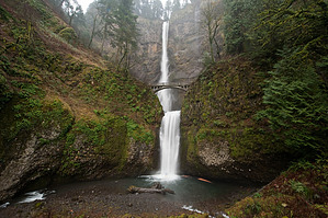
Give my regards to Holbert and Kiwanis
by Dano

This was my first hike in Oregon since moving to Washington State from Arizona. It is one of the most visited places in Oregon, and for good reason: a 550-foot high waterfall, within 100 yards of an interstate highway. It's less than a 30-minute drive from downtown Portland.


Most folks walk the short distance to the lodge and base of the falls; some even hike the 1/4 mile to the bridge for a closer view. Even this short distance creates a great photography opportunity.
remove free decal offer
However, the best view is from the top, via a 1.1-mile paved trail. Once you get past the bridge, the crowds will dissipate quickly, because of the steepness of the trail. The good people of Oregon put a series of signs that count the number of switchbacks to the top (there are 11), along with markers at every quarter-mile. There are several places to stop and view the falls along the way, and the higher up you get, the better the view of the Columbia River Gorge. The only downside is the noise from the highway and railway below. This is your motivation to get to the top because once you cross to the other side, man-made noise is replaced by natural running water noise.

After about 3/4 mile, the trail heads East away from the falls, but then comes over a rise, and then it's a short distance downhill, along the creek, to the viewing area that allows you to look right over the edge. The viewing deck will keep any folks from foolishly trying to get too close, but allows you to see down to the lodge, and out along the Gorge.

One warning: Please be sure to secure and hide valuables in your car. Thieves like to smash in windows and grab what they can see.

2010-03-26 Dano


    Check out the Official Route and Triplogs.
    Leave No Trace and +Add a Triplog after your hike to support this local community.
    WARNING! Hiking and outdoor related sports can be dangerous. Be responsible and prepare for the trip. Study the area you are entering and plan accordingly. Dress for the current and unexpected weather changes. Take plenty of water. Never go alone. Make an itinerary with your plan(s), route(s), destination(s) and expected return time. Give your itinerary to trusted family and/or friends.

     Permit $$
    None

    Mount Hood Forest
    more info


     Directions
    or
     Road
    Paved - Car Okay

    To hike
    From Portland, take Interstate 84 East to Exit 31. Note that the exit is from the LEFT lane. Remember to hide and secure your valuables.

    A longer, but much more scenic route, is to take US 30 (Columbia River Highway). Take I-84 East to Exit 17 at Troutdale, and follow the signs.
    page created by Dano on Mar 26 2010 8:05 pm
     90+° 8am - 6pm kills
    helpcorrectionissue

    end of page marker