 Route Editor

| Guide | ♦ | 3 Triplogs | 0 Topics |
details | drive | permit | forecast | route |
stats |
photos | triplogs | topics | location |
| 12 | 3 | 0 |
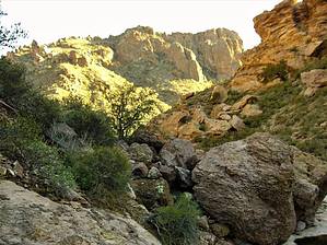
primarily loose rock by caquark  This "trail" is an approximately 7.5 mile, rugged, undesignated route that will take most of the day. Do this loop in a clockwise direction! This "trail" is an approximately 7.5 mile, rugged, undesignated route that will take most of the day. Do this loop in a clockwise direction!Walk back out along the road before beginning a northward approach to the Grass Canyon entrance rather than scrambling along the range's foothills. The route is primarily on loose rock through dense vegetation and traverses numerous washes. You should be aiming for a significant pillar of stone. Head around the base of this pillar, bypassing the first canyon on the right to a second one, which is the true entrance to Grass Canyon. From its entrance, the saddle at the ridgeline is apparent.
Once you reach the saddle, you are about 4 miles into the hike with views both to the east and west. Cross over the saddle, staying to the right and along the slope until you can climb down and reach the wash that descends to the east. You will come to some junipers, and the wash will begin to bottleneck. Continue following the wash east until it joins the North Fork, which heads to the south, turn right and follow it. You will continue to fight brush and bramble as you find a way through the canyon, scrambling over and down the many sills, at times swinging through or hopping off boulders. Your footing will be a mix of slab rock, boulders of varying sizes, loose rock, and sand. It becomes an easier walk towards the canyon's end, where it emerges into Alamo Canyon (itself heading to the west). Soon after emerging into Alamo Canyon, there will be an old corral on your left. You will have completed about another 2.5 miles of your hike. Once you come across the corral, climb the trail (found on the south side of the wash) that leads to it. You will rejoice that your feet are on hardpack and the remaining mile of your hike is well defined. Follow this trail as it re-crosses the wash a little further downstream and leads you to the Alamo Campground. Along the trail, you'll pass an old cowboy line camp building and eventually see the outhouse building (at the Alamo Campground) on your right. Follow a branch from the trail up a short, steep slope to this building. You are back at the trailhead. Sources: info from Visitor's Center, Molvar's "Hiking Arizona's Cactus Country", and personal experience Check out the Official Route and Triplogs. Leave No Trace and +Add a Triplog after your hike to support this local community. One-Way Notice This hike is listed as One-Way. When hiking several trails on a single "hike", log it with a generic name that describes the hike. Then link the trails traveled, check out the example. | |||||||||||||||||||||||||||||||||||||||||||||||||||||||||||||||||||||||||||||||||||||||||||||||||||


