Route Editor

| Guide | ♦ | 5 Triplogs | 0 Topics |
details | drive | permit | forecast | route |
stats |
photos | triplogs | topics | location |
| 43 | 5 | 0 |
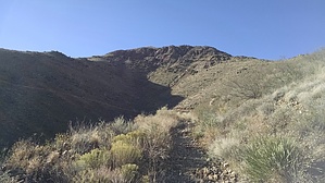
Benjies Kite by The_Dude  Enter the park on the west side of the mountains and pay your entrance fee for Tom Mays Park, then continue to the area labeled "Mundys Gap".
There is a large CB antenna at the top, sweeping views of El Paso, Juarez, Fort Bliss military base, and all the surrounding mountain ranges. It was remarkably windy the morning I did my hike. Windy conditions are most common here in the spring. Return the way you came, make sure you get out before 5 p.m. when they lock the gates. Gate Policy: If a gate is closed upon arrival, leave it closed after you go through. If it is open, leave it open. Leaving a closed gate open may put cattle in danger. Closing an open gate may cut them off from water. Please be respectful, leave gates as found. The exception is signage on the gate directing you otherwise. Check out the Official Route and Triplogs. Leave No Trace and +Add a Triplog after your hike to support this local community. | |||||||||||||||||||||||||||||||||||||||||||||||||||||||||||||||||||||||||||||||||||||||||