username
X
password
register
for free!
help
  This is likely a great time to hike this trail!  Check out "Preferred" months below, keep in mind this is an estimate.
 

Ocqueoc Falls Bicentennial Pathway, MI

Guide 2 Triplogs  0 Topics
  3.5 of 5  
Fav
Wish
0
details
drive
no permit
forecast
route  
stats
photos
triplogs
topics
location
19 2 0
Statistics
tap row or icons for details
Difficulty 1 of 5
Route Finding 1 of 5
Distance Network 6 miles
Trailhead Elevation 685 feet
Elevation Gain -62 feet
Accumulated Gain 290 feet
Avg Time Hiking 1-3 hours
Kokopelli Seeds 6.97
 Backpack No
unreported if dogs are allowed
editedit > ops > dogs to adjust
feature photo
Photos Viewed All MineFollowing
7  2022-07-06 Vashti
12  2018-06-28 FOTG
Author
author avatar Guides 37
Routes 556
Photos 10,872
Trips 1,052 map ( 10,600 miles )
Age 43 Male Gender
Location AZ
Co-Author
co-author avatarGuides 16,843
Routes 17,472
Photos 24
Trips 1 map (6 Miles)
Age 28 Male Gender
Location HAZ, TrailDEX
Associated Areas
list map done
Eastern Region
Historical Weather
Trailhead Forecast
Radar Map
Expand Map
Preferred Sep, May, Jun, Aug → 8 AM
Seasons   ALL
Sun  6:02am - 7:07pm
Official Route & 2 Rts
 
0 Alternative


remove free decal offer
especially scenic in the fall
by FOTG & HAZ_Hikebot

  Likely In-Season!
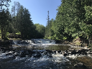
Ocqueoc Falls are the only recognized waterfalls in Michigan's lower peninsula. The falls can be reached via an easy tenth of a mile stroll along a paved pathway. However, an additional six miles of trails can be reached from the parking and falls areas. The trails create four loops with distances ranging from just under three miles to six miles. The well marked and numbered trails will take you along the Ocqueoc river through a pleasant forest of pine and hardwood and along a ridgeline that runs parallel to the river. The area has a reputation for being especially scenic in the fall.


2018-07-02 FOTG & HAZ_Hikebot


    Check out the Official Route and Triplogs.
    Leave No Trace and +Add a Triplog after your hike to support this local community.
    WARNING! Hiking and outdoor related sports can be dangerous. Be responsible and prepare for the trip. Study the area you are entering and plan accordingly. Dress for the current and unexpected weather changes. Take plenty of water. Never go alone. Make an itinerary with your plan(s), route(s), destination(s) and expected return time. Give your itinerary to trusted family and/or friends.

     Permit $$
    no fees or permits reported

    if incorrect tell us about it


     Directions
    or
     Road


    To hike
    page created by HAZ_Hikebot on Mar 09 2010 6:12 pm
     90+° 8am - 6pm kills
    helpcorrectionissue

    end of page marker