Route Editor

| Guide | ♦ | 19 Triplogs | 0 Topics |
details | drive | no permit | forecast | 🔥 route |
stats |
photos | triplogs | topics | location |
| 260 | 19 | 0 |
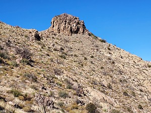
A Big Enchilada by DixieFlyer  Overview OverviewTortilla Mountain is an iconic peak in the west central Superstition Wilderness. The Tortilla Mountain summit is at an elevation of 4,918 feet and it has a prominence of 1,038 feet. Count on some off-trail hiking through rugged and steep terrain for this one. Etymology The nearby town of Tortilla Flat takes its name from masses of flat rocks in the area that resemble stacks of tortillas. Tortilla Mountain is a prime example of this geology. Source: Arizona's Names (X Marks the Place), by Byrd Howell Granger
There is not a standard route to this hike, so this will not be a step-by-step guide for a recommended route. Rather, this will be a commentary on some possible routes. However, this guide will provide a recommendation on what to do when you get to the summit block, which can look intimidating. Hike From the Tortilla Trailhead just off of Apache Trail, hike on FR 231 for about 3.25 miles until you come to the Peters Trailhead at Tortilla Well. Note that with the proper vehicle, you could drive to the Peters Trailhead, thus saving about 6.5 miles round-trip of road walking. However, most stock 4WD vehicles will not have enough clearance to make this drive. Once at Peters Trailhead, take Peters Trail #105. Follow this trail for 1-2 miles until you decide to leave the trail and head west towards Tortilla Mountain. The author of the guide went about 1.3 miles and left the trail at Indian Springs. Some have continued for nearly a mile before leaving the trail at a saddle past Kane Spring. Others have left the trail at a drainage before getting to Indian Spring. Whatever you do expect some steep, rugged terrain with unfriendly vegetation. Dressing defensively will be prudent. If you choose to go up some of the drainages you'll likely encounter some dryfalls requiring short class 3 moves. It is a good idea to check triplogs and read about the experiences of other hikers. You will most likely be approaching the summit from the southeast. From this direction, the summit looks intimidating. However, if you traverse around to the northeast side of the summit block you'll see a straightforward class 2 route to the top. This climb is angled in nicely, and if you made it this far you should not have any problem getting to the top via this route. Synopsis This hike involves what most would consider to be some tough off-trail hiking. However, the off-trail portion is fairly short, and if you make it to the summit you'll be rewarded with some amazing views of the Superstitions and other surrounding mountain ranges. Check out the Official Route and Triplogs. Note This is a moderately difficult hike. Leave No Trace and +Add a Triplog after your hike to support this local community. | |||||||||||||||||||||||||||||||||||||||||||||||||||||||||||||||||||||||||||||||||||||||||||||||||||||||||||||||||||||||||||||||||||||||||||||||||||||||||||||||||||||||||||||||||||||||||||||||||||||||||