 Route Editor

| Guide | ♦ | 14 Triplogs | 2 Topics |
details | drive | no permit | forecast | 🔥 route |
stats |
photos | triplogs | topics | location |
| 122 | 14 | 2 |
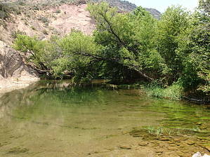
Quieter Part of Fossil Creek by jacobemerick   Overview OverviewA scenic adventure that drops off the tip of Deadman Mesa and follows Fossil Creek before ending at the Verde River Trail. Can be combined with a few other routes, including Ike's Backbone or the creek itself, to make a long day hike or even multi-day outings. It also happens to be the furthest northwest trail in the Mazatzal Wilderness. Hike Reaching the trailhead is the first challenge and, depending on your vehicle, could add up to 7 miles to the official route. FR 591 is a rocky, unmaintained track that descends 1300' after leaving Fossil Creek Road, getting progressively worse the further out on Deadman Mesa it gets. There are multiple washed out sections and steep drops, plus the rocks that make most of the road are hungry for soft tires.
Now comes the descent. An iconic 'doorway' shows up, with the remains of an old gate tucked between a large tree and rock outcropping, and then the trail tumbles down 1400' to Fossil Creek. The first half of this drop slides along the eastern side of basalt fins before coming to rest on a small flat. From here, the trail twists to the west and leaves the ridge of Deadman Mesa behind, zig-zagging down a steep, grassy hillside. The cairns at this section are large and numerous but may be hard to pick out due to overgrowth. Thicker clusters of trees show up at 3.4 miles, and the trail becomes hard(er) to follow this close to the creek. That's fine - just head towards the sound of rushing water. The trail basically disappears for the next few miles anyway. There are a few flat spots for camping here, nothing obvious or developed. There are also some great pools for cooling off at this point. Now comes the fun part: follow Fossil Creek downstream beyond the Hardscrabble Creek confluence. There are very few cairns along this section (I only found a handful in one spot in 2017) and no tread to speak of. One could simply jump in the creek and splash through the deep pools and over the waterfalls or try hiking along the overgrown banks. If you do the latter, steep cliffs along the creek will force somewhere between 4 and 8 crossings, many of them 'wet' crossings. Based on the enclosed nature of this creek bed and its apparent ability to flood-out any sort of path, I can only wish you good luck on this section. At least it's pretty. A small, likely dry drainage flows in from the east side at 5.0 miles. Get to the east side of Fossil Creek and, near where the dry drainage meets the creek, bushwhack up the crumbling bank. This is a short, unpleasant experience. Above the bank, there are the remains of the old track and a few cairns. The cairned path climbs up the hill, going south then east then south again, and is sometimes hard to track through fields of foxtails. Aim for the saddle to the southeast if things get hairy. The junction with Verde River Trail has a few huge cairns built up but is unsigned. From here, you could follow this new trail left to Twin Buttes Trailhead, right (mostly straight) towards the East Verde / Verde River junction, or turn around and backtrack to Deadman Mesa. Water Sources Fossil Creek is a year-round and wonderfully clear source. Deadman Tank appears unreliable at best. Camping While there are no apparent campsites along the creek, there is plenty of shade and all that water to enjoy. Gate Policy: If a gate is closed upon arrival, leave it closed after you go through. If it is open, leave it open. Leaving a closed gate open may put cattle in danger. Closing an open gate may cut them off from water. Please be respectful, leave gates as found. The exception is signage on the gate directing you otherwise. Check out the Official Route and Triplogs. Leave No Trace and +Add a Triplog after your hike to support this local community. One-Way Notice This hike is listed as One-Way. When hiking several trails on a single "hike", log it with a generic name that describes the hike. Then link the trails traveled, check out the example. | |||||||||||||||||||||||||||||||||||||||||||||||||||||||||||||||||||||||||||||||||||||||||||||||||||||||||||||||||||||||||||||||||||||||||||||||||||||||||||||||||||||||||||||||||||||||||||||||||||||||||


