 Route Editor

| Guide | ♦ | 87 Triplogs | 0 Topics |
details | drive | permit | forecast | route |
stats |
photos | triplogs | topics | location |
| 573 | 87 | 0 |
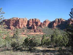
Schnebly Twist by fprose   Munds Wagon Trail follows Schnebly Hill road as it goes from Sedona up to the rim east of Sedona. The trail itself begins at a trailhead used by Huckaby and Mags Draw and follows the road and the wash up the hill, crisscrossing both several times. Munds Wagon Trail follows Schnebly Hill road as it goes from Sedona up to the rim east of Sedona. The trail itself begins at a trailhead used by Huckaby and Mags Draw and follows the road and the wash up the hill, crisscrossing both several times.Familiar with the area, I decided to try the trail when I had run out of un-explored options in the Sedona area. I always thought, "this can't be good; it's right next to the road." Pleasantly surprised, we saw (and heard) very little traffic/... just the occasional Pink or Red tour Jeep and the rental car that will never quite be the same again. While the trail does cross the road in a couple of locations, you are far enough away most of the time.
After viewing the sights along Schnebly Hill Road many times, it was most enjoyable to concentrate on the prominent Sedona features such as Cow Pies and Mitten Ridge without worrying about running my vehicle off the road. While the trail is not difficult to follow, multiple cairns mark the way in areas that could be confusing. Not recommended for mid-day during hot summer months, the trail does have shaded rest spots. There is no water. During periods of heavy rain or snowmelt, the wash you cross many times would be dangerous and impassable.
Coconino FS Details This is a scenic trail connecting Schnebly Hill Trail to the Margs Draw and Huckaby Trails. It is well-marked, mostly moderate in grade and offering occasional shade from Arizona cypress over its entire length. It may be hiked one-way with arranged transportation and, hiked east to west, as described here would be rated moderate. Beginning from the East Trailhead, the trail descends moderately to the south and levels out as it partially circles the base of Merry-Go-Round Rock with spectacular views west down Bear Wallow Canyon toward Sedona and south to Munds Mountain. It then resumes its descent and bends to the west, crossing a switchback of Schnebly Hill Road twice with good views of Mitten Ridge on the right (north). Now, the trail drops into Bear Wallow Wash and follows in or beside the drainage for a considerable distance. The trail then climbs out of the wash, crosses a low ridge and another wash and then climbs moderately. Now, high above the canyon floor, there are great views back to the Mogollon Rim and of nearby red rock formations at the west end of Mitten Ridge to the right. The trail continues west and crosses the road twice on a high area overlooking Uptown Sedona and many of the area formations. After a brief descent and climb, the trail ends at 4.0 miles at the West Trailhead at the parking area for the Margs Draw and Huckaby trailheads just off Schnebly Hill Road. It is possible to take shorter hikes on portions of the trail utilizing the various mid-trail access points, one at Merry-Go-Round and others where the trail intersects or passes next to Schnebly Hill Road. Road crossings are marked with basket cairns. This historic trail follows one of the first and most popular cattle trails out of the Sedona area. Upgrading of the trail began in 1896, but its completion as a wagon trail awaited the work of pioneer J.J. Thompson, funded by Coconino County, in 1902. It was known as the Munds Road and later as the Schnebly Hill Road. Check out the Official Route and Triplogs. Leave No Trace and +Add a Triplog after your hike to support this local community. One-Way Notice This hike is listed as One-Way. When hiking several trails on a single "hike", log it with a generic name that describes the hike. Then link the trails traveled, check out the example. | ||||||||||||||||||||||||||||||||||||||||||||||||||||||||||||||||||||||||||||||||||||||||||||||||||||||||||||||||||||||||||||||||||||||||||||||||||||||||||||||||||||||||||||||||||||||||||||||||||||||


