 Route Editor

| Guide | ♦ | 14 Triplogs | 0 Topics |
details | drive | permit | forecast | map |
stats |
photos | triplogs | topics | location |
| 156 | 14 | 0 |
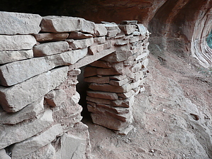
Short and Sweet by fprose   The trail starts from the Brins Mesa West Trailhead. The trail is unofficial and doesn't show up on many local Sedona hiking maps or the Forest Service signpost. The trail starts from the Brins Mesa West Trailhead. The trail is unofficial and doesn't show up on many local Sedona hiking maps or the Forest Service signpost.This trail's rewards are spectacular views and two ruins sites; one in the best condition I've seen in the Sedona area.
The path itself is quite easy to follow, and it's marked with hiker cairns along the way. After crossing a wash (with grey boulders) and a red rock arroyo, you will begin a climb of 450 feet. Use caution. The sand and rocks are loose. At the top, you will follow the trail as it proceeds south towards a prominent red rounded rock that marks the Northern beginning of the canyon. The trail goes around the rock and into the canyon. From here, you are walking on a 15-foot wide ledge with sheer walls to the east and a sheer drop to the west... not a place for kids or those who fear heights. About half-way into the canyon, you will see a long shallow cave with ruins. It's possible to climb up to the ruins. As you approach the end of the canyon, look down into the north, and you will see the sight of the second ruins - very well preserved. At this point, you have gone about 1.5 miles. But you may continue to follow the canyon ledge around the northwestern mouth. It curves around another large toe rock and goes into the canyon that contains Devils Bridge... viewable from the trail.
Check out the Triplogs. Leave No Trace and +Add a Triplog after your hike to support this local community. | ||||||||||||||||||||||||||||||||||||||||||||||||||||||||||||||||||||||||||||||||||||||||||||||||||||||||||||||||||||||||||||||||||||||||||||||||||||||||||||||||||||||||||||||||||||||||


