Route Editor

| Guide | ♦ | 9 Triplogs | 1 Topic |
details | drive | permit | forecast | map |
stats |
photos | triplogs | topic | location |
| 96 | 9 | 1 |
  Happy Trails! Check out the Triplogs. Leave No Trace and +Add a Triplog after your hike to support this local community. | |||||||||||||||||||||||||||||||||||||||||||||||||||||||||||||||
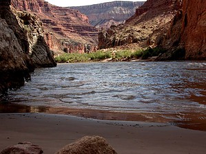
Shinumo Wash, AZ |
| Guide | ♦ | 9 Triplogs | 1 Topic |
details | drive | permit | forecast | map |
stats |
photos | triplogs | topic | location |
| 96 | 9 | 1 |
Happy Trails! Check out the Triplogs. Leave No Trace and +Add a Triplog after your hike to support this local community. | |||||||||||||||||||||||||||||||||||||||||||||||||||||||||||||||
|
Permit $$
Special Use Special Navajo permit to drive to trailhead, overnight permit if leaving vehicle overnight. No NPS entrance fee. NPS backpacking permit required to camp below the rim. Grand Canyon National Park Details for each are occasionaly below numerous alerts • Entrance Fee • Overnight/Backpacking Permits • Grand Canyon Use Areas Map • Rim-to-Rim and Extended Day Hike/Run |
|
Road
|
|
|
|
|