username
X
password
register
for free!
help
  

Pipiwai Trail to Makahiku and Waimoku Falls, HI

Guide 5 Triplogs  0 Topics
  4.3 of 5  
Fav
Wish
0
HI > Maui
details
drive
permit
forecast
route  
stats
photos
triplogs
topics
location
55 5 0
Statistics
tap row or icons for details
Difficulty 2.5 of 5
Route Finding 1 of 5
Distance Round Trip 3.8 miles
Trailhead Elevation 139 feet
Elevation Gain 646 feet
Accumulated Gain 657 feet
Avg Time Round Trip 2-3 hours
Kokopelli Seeds 7.09
 Interest Seasonal Waterfall, Perennial Waterfall, Seasonal Creek & Perennial Creek
 Dogs not allowed
feature photo
Photos Viewed All MineFollowing
Inaugural Calculation on Button Tap!
5  2024-07-27 leonesiegel
21  2023-10-21 The_Eagle
20  2016-03-10 Lucyan
9  2011-06-29 Sun_Ray
Author
author avatar Guides 41
Routes 1,626
Photos 14,983
Trips 2,760 map ( 18,597 miles )
Age 69 Male Gender
Location Far NE Phoenix, Az
Associated Areas
list map done
Maui Region
Historical Weather
Trailhead Forecast
Radar Map
Expand Map
Preferred Jan, Jan, Jan, Jan → 8 AM
Sun  6:09am - 6:36pm
Official Route & 3 Rts
 
0 Alternative


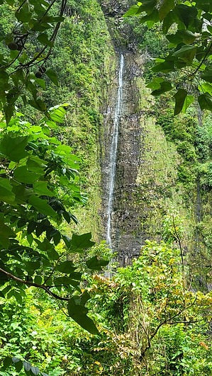
Haleakala Summit's Redheaded Stepchild
by The_Eagle

This trail is located in the southeastern reaches of Haleakalā National Park, south of Hana. The Pipiwai Trail leading to Makahiku and Waimoku Falls is an awe-inspiring hike that offers views down into Pipiwai Stream and the aforementioned falls.


This hike takes you through lush bamboo forests and offers views of the two magnificent waterfalls, Makahiku Falls and Waimoku Falls. Makahiku Falls cascades 200 feet down a sheer lava rock wall, while Waimoku Falls, the main attraction, plunges nearly 400 feet into a serene pool.
remove free decal offer
The trail also winds through the interesting bamboo forest, where the towering bamboo canopies create a surreal environment. The history of this area is deeply rooted in Hawaiian culture, where the bamboo groves were once considered sacred.

Haleakalā National Park, where this trail is located, is home to a wide variety of unique flora and fauna. Keep an eye out for native birds like the ʻApapane and ʻIʻiwi.

This trail can become busy, so plan to start early

2023-11-01 The_Eagle


    Check out the Official Route and Triplogs.
    Leave No Trace and +Add a Triplog after your hike to support this local community.
    WARNING! Hiking and outdoor related sports can be dangerous. Be responsible and prepare for the trip. Study the area you are entering and plan accordingly. Dress for the current and unexpected weather changes. Take plenty of water. Never go alone. Make an itinerary with your plan(s), route(s), destination(s) and expected return time. Give your itinerary to trusted family and/or friends.

     Permit $$
    NPS


     Directions
    or
     Road
    Paved - Car Okay

    To hike
    Located off the Hana Hwy, 10 miles south of Hana
    page created by HAZ_Hikebot on Nov 01 2023 4:38 pm
     90+° 8am - 6pm kills
    helpcorrectionissue

    end of page marker