Route Editor

| Guide | ♦ | 31 Triplogs | 0 Topics |
details | drive | permit | forecast | route |
stats |
photos | triplogs | topics | location |
| 212 | 31 | 0 |
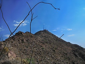
Desert Sierra-Solitude by bwardintyre  *** W A R N I N G *** Use of this land is not legal without permission from Gila River Indian Res. Hearsay dictates they do not grant permission to anyone. At 4512 feet, the highest point in the Estrellas is not often hiked, which is unusual for a significant peak this close to the metropolitan Phoenix area. Probably the rugged appearance and lack of obvious routes tend to intimidate those hikers that might otherwise be interested.
I find that heading straight up the most significant drainage that attains the ridgeline just SE of the approach to the highest peak works for me, but if one were just to pick the route that appears the least difficult, it would probably be this one. One advantage of this route is that it is in the shade for the first 2 or 3 hours of the day, which is nice for a summer hike. When I reached the starting point at 5:15 AM, it was 102 degrees, but that dropped to 101 degrees by 5:30 when I started the hike. It is the warmest overnight low I have ever seen. At 11:00 AM, when I returned to the vehicle, it was 112. Of course, the higher elevations were much cooler. I wore shorts for the hike with the knowledge that I would be traveling through some brush, but my legs were only moderately scratched at the end of the hike. At one point, several buzzards wheeled over me for several minutes; apparently, they used their sense of smell to home in on me since I was sweating quite a bit but moving too fast to appear as dead meat. I was able to do the up-hike in 2:13, but a hiker in good shape in cooler weather could cut at least half an hour off this time. There is an elevation gain of about 2800 feet. There is a very messy communications installation at the summit. It is also possible to hike the summit from the other (NE) side, but the lack of good access and exposure to the sun means that it would be a strenuous summer hike. Last winter, 2 of us shuttled a vehicle to the Rainbow Valley trailhead in the pre-dawn hours and then drove around to the competitive bike track in the back of PIR and started hiking there with the intention of hiking completely over the mountain and finishing at the shuttle vehicle in Rainbow Valley. It was a neat hike and required about 9 hours of hiking time. It is a good 5 miles hiking across the desert from PIR down to the base of the highest peak, and then we proceeded up an obvious ridge to above a cliff band where we traversed to the right, then finished the ascent. You would probably want to do this up and over maneuver from one side to the other only if you had done the hike from Rainbow Valley first. I am presenting these hikes here to encourage other hikers to try the routes. Check out the Official Route and Triplogs. Note This is a more difficult hike. It would be unwise to attempt this without prior experience hiking. Leave No Trace and +Add a Triplog after your hike to support this local community. | ||||||||||||||||||||||||||||||||||||||||||||||||||||||||||||||||||||||||||||||||||||||||