Route Editor

| Guide | ♦ | 28 Triplogs | 1 Topic |
details | drive | no permit | forecast | 🔥 route |
stats |
photos | triplogs | topic | location |
| 203 | 28 | 1 |
Canyons are inherently risky. Flash floods occur without notice on sunny days. Technical skills & surrounding topography knowledge required yet does not eliminate risk.
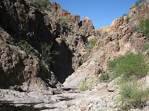
Cruzin A Canyon by AZLOT69   Overview OverviewWillow Creek is one of four major North-South drainages that pass thru the Goldfield Mountains on the way to the Salt River and Saguaro Lake. It originates in the area of Little Four Peaks, then crosses to the west under Highway 88 near Apache Gap and parallels Highway 88 on its west-northwest side. Warning This hike is not for beginners. It is an off-trail bushwhack for its entire length. It will test your route-finding skills and sense of direction. Map and GPS reading skills are a plus. Flash flooding is also a concern. These dry washes and canyons can fill with water quickly and the water can be strong and violent. Evidence abounds that water at depths over ten feet deep has passed this way. Water will significantly add to the difficulty of this hike as the entire hike is in the waterway.
The hike can be accomplished in either direction but is described here from South to North. The trailhead is a paved pullout along Highway 88 at milepost 205.9 and is signed as a scenic view. There are no facilities and the pullout will only hold about five vehicles. The trailhead provides the best single overview of the area you are about to enter with Four Peaks towering in the distance. Walk south along the shoulder of the road for about one hundred yards and look for the best place to enter the creek bed off to your right. Once in the creek bed turn right. The creek bed is slick rock and initially requires some light scrambling. Very quickly you will come to three drop-offs of 30 feet, 40 feet, and another 40 feet, each with a swimming pond at its base. These are class three obstacles that would require rope skills if desired. The obstacles can be bypassed by going high right over the saddle and then returning to the creek. Shortly thereafter you will come to another 30-foot spillover which is also class three. You can bypass this obstacle as well by going high left and then dropping back into the creek bed. Another major tributary enters from the right. This is a typical Goldfield hike with brilliantly lichen-covered rocks all around. The creek becomes slick rock for a while then comes out of the canyon for a short time. Any road noise you may have heard is gone now as there is a canyon between you and the road. As remote as it feels, highway 88 is never far away off to your right. The creek bed eventually spreads out into a flat area and becomes choked with vegetation. Bypass this on the left, staying out of the creek bed until it becomes more defined again just ahead then return to the creek. Generally, there is a good animal trail to follow. The canyon walls increase again as you find your vision of the horizon limited. The canyon is twisting back and forth more often and you will come to a major set of drop-offs. This is at about 2.37 miles. These are class three with swimmers at the bottom. These can be bypassed by retreating up the canyon and taking the slick rock area up left. REMEMBER THIS WAS ACTUALLY ON YOUR RIGHT. Go up to the saddle, enjoy the view, then work your way back down to the creek bed. The creek bed stays well-defined now as it meanders downstream. You ultimately arrive in an area of the canyon that seems to be boxing you in. Much darker rock towers on either side of the canyon. Huge boulders block progress which you can bypass up out of the creek bed on your left. Perseverance will get you to a nice if not narrow view of the Salt River. You can return the way you came or if you have made arrangements, retreat upstream about an eighth of a mile and take the first up-sloping canyon now on your left. This will take you out to the alternative North trailhead described below. Alternatives The North trailhead, N33 33.186 W111 27.054 is a parking area off of the driveway to the Mormon Flat Dam. This driveway is marked with a prominent mailbox at milepost 208.7 on Highway 88. Follow this driveway north one-half mile to the parking area on your left. Follow the canyon west from the south side of this parking area to Willow Creek. This hike can be accomplished in a variety of creative ways. Shuttle, self-shuttle with a bicycle, key exchange, or out and back. Check out the Official Route and Triplogs. Leave No Trace and +Add a Triplog after your canyon trip to support this local community. | ||||||||||||||||||||||||||||||||||||||||||||||||||||||||||||||||||||||||||||||||||||||||||||||||||||||||||||||||||||||||||||||||||||||||||||||||||||||||||||||||||||||||||||||||||||||||||||||||||||||||||||