username
X
password
register
for free!
help
 This is likely a great time to hike this trail!  Check out "Preferred" months below, keep in mind this is an estimate.
 

Lime Kiln Trail, WA

Guide 1 Triplog  0 Topics
  0 of 5  
Fav
Wish
0
details
drive
no permit
forecast
route  
stats
photos
triplog
topics
location
12 1 0
HAZ reminds you to respect the ruins. Please read the Archaeological Resources Protection Act of 1979 & Ruins Etiquette
Statistics
tap row or icons for details
Difficulty 2 of 5
Route Finding 1 of 5
Distance Round Trip 7.2 miles
Trailhead Elevation 614 feet
Elevation Gain 600 feet
Accumulated Gain 924 feet
Avg Time Round Trip 3.5 hours
Kokopelli Seeds 11.82
 Interest Ruins, Historic, Seasonal Waterfall, Seasonal Creek & Perennial Creek
 Backpack No
feature photo
Photos Viewed All MineFollowing
Will recalculate on button tap!
12  2013-02-17 sagamihara_hiker
Author
author avatar Guides 15
Routes 265
Photos 3,881
Trips 366 map ( 2,529 miles )
Age 52 Male Gender
Location Sagamihara, Japan
Associated Areas
list map done
North Cascades Region
Historical Weather
Trailhead Forecast
Radar Map
Expand Map
Preferred Sep, Jun, Jul, Aug
Seasons   ALL
Sun  5:31am - 6:41pm
Official Route
 
0 Alternative


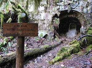
Riverside hike to an old lime kiln
by sagamihara_hiker

 Likely In-Season!
The Lime Kiln Trail follows the South Fork Stillaguamish River and gives you a window into some old mining history. The namesake is a century-old lime kiln. The kiln, located 2.6 miles up the trail, is a 20-foot tall stone structure once used to cook limestone. The powdered lime was then transported by the Everett and Monte Cristo Railway to smelters and mills in Everett. Built in 1892 and abandoned in 1934, a section of this rail line has been resurrected as part of the Lime Kiln Trail. Be sure to check out the photos and and historical notes on the trailhead sign (this information is on the back -- we didn't see it until we returned at the end of our hike).


The first part of the hike crosses some private property but is well signed. After passing Hubbard Pond and creek on a well built bridge, walk a short distance to a well-marked junction. Here a sign directs you to head left. Shortly thereafter pickup the sounds of the South Fork Stillaguamish River which you'll follow along for the rest of the hike. This part of the trail is the former railbed of the old Everett and Monte Cristo Railway and has a nice, easy grade.
remove free decal offer
Near the lime kiln site, you'll pass scores of historical relics literally littering the forest floor. Old saw blades, bricks, bottles, stove parts, and bed frames are just some of the items you may see.

Beyond the old kiln, the trail continues for another 0.8 mile, ending at where a rail bridge once spanned the river. You can see two moss covered concrete pads on each side of the rive. A short loop trail to the left leads down to the river bed and nice, wide rocky beach area. A good place to enjoy lunch and the river before heading back.

2013-02-17 sagamihara_hiker


    Check out the Official Route and Triplog.
    Leave No Trace and +Add a Triplog after your hike to support this local community.
    WARNING! Hiking and outdoor related sports can be dangerous. Be responsible and prepare for the trip. Study the area you are entering and plan accordingly. Dress for the current and unexpected weather changes. Take plenty of water. Never go alone. Make an itinerary with your plan(s), route(s), destination(s) and expected return time. Give your itinerary to trusted family and/or friends.

     Permit $$
    None


     Directions
    or
     Road
    FR / Dirt Road / Gravel - Car Okay

    To hike
    From Seattle, take I-5 north to US 2 (east). Then take WA 204 toward Lake Stevens. Turn left on WA 9 and then right on WA 92 toward Granite Falls. At the end of Granite Falls, turn right on S Alder Avenue. At the T intersection, turn left on E Pioneer Street (which becomes Menzel Lake Road). About a mile later, turn left on Waite Mill Road. Follow the signs for the Robe Canyon Historic Park and Lime Kiln Trail. There will be a short gravel road that goes uphill and then the trailhead parking is on the left.
    page created by HAZ_Hikebot on Feb 17 2013 5:45 pm
     90+° 8am - 6pm kills
    helpcorrectionissue

    end of page marker