 Route Editor

| Guide | ♦ | 36 Triplogs | 3 Topics |
details | drive | no permit | forecast | 🔥 route |
stats |
photos | triplogs | topics | location |
| 453 | 36 | 3 |
Fly fishers gold mine by te_wa   Ambush at the Perkins Store Ambush at the Perkins Store. . . . . . On the twenty-second day of September in 1887, Sheriff William Mulvenon of Yavapai County Arizona, along with a posse sprinkled with Tewksbury sympathizers, set about the destruction of the remaining Grahams and Blevins. As John Graham and Charlie Blevins approached the unfinished Perkins store, Mulvenon stepped out to demand their surrender. In Pleasant Valley at that time, he was lucky they didn't shoot him on sight. Instead, they turned their horses to get out of range of the perceived threat. Within seconds a hail of bullets sent their way by the posse, hidden behind half-built walls, ended both their lives. John's brother, Tom Graham, escaped to Phoenix only to lose his life half a decade later at the hands of Ed Tewksbury. . . . . . . This is only a small part of the amazing saga of the Pleasant Valley War. In all, fifteen cattlemen and at least three sheep men were slain over the five years the battles ensued.
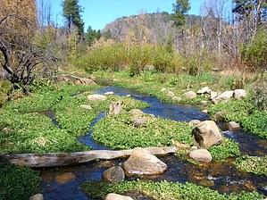
This hike starts from the East end of a campground at 6545 feet. It winds its way along a normally dry runoff about 1/4 mile to the creek/canyon bottom. The "canyon" is very shallow and bordered by rolling hills with a typical Rim country riparian environ. (If you come here to fish, you have many sections of the creek at this point that will offer bait-friendly waters, otherwise around the 1-mile mark and just past the OW bridge, you can only catch and release with artificial lures). Heading downstream from the canyon bottom, you will head south-east for 1/4 mile to a barbed fence, continue along a fisherman's trail that skirts a large meadow on the right. It doesn't stay in the shade after noon but beats bushwacking the creek. Since the going was pretty slow near the water, I found that I could both see more from the meadow's ledge and make better time to my destination, the hike's end at the Fort Apache Reservation. Just past the OW bridge, a dirt road is an easy way to get deeper into the canyon. I took it. There are many open grass-filled meadows along this 5-mile hike that tempt one to kick off the boots, hide under a hat, and catch some zzz's. At first sight, you start to see the evidence of the fire that ravaged the canyon in 2001. Because of the fires, erosion allowed scouring floods to impact the creek. A year later-for instance, what was once a living riparian habitat now has less canopy of trees providing less shade and allowing the water temps to climb higher than the once-thriving Brown Trout population can handle. It is said by the US Forest Service and AZ Game and Fish that the brown trout numbers are down TEN-fold compared to 1999. Hopefully, with the efforts of AZGF, the creek can be restored to a Blue Ribbon destination. At any rate, there are rainbow trout in the stream, and boy are they plentiful! Upstream at the hatchery, which produces some 300,000 catchable fish a year, several of these 5-6 inch trout escape and make their way downstream. I noted that at mile 2.5, the road from OW bridge starts climbing upwards, so that is when I left for the stream bed once again and finished the next 2 miles crossing the creek, taking pictures and scouting campsites. This hike generally follows a very easy to negotiate creekbed and meadow. At mile 3.75, it finally changes personality by entering into a basalt cliff canyon that zigzags its way for the next 1.25 miles. This is where the fun starts, so plan on getting your feet wet! I hopped and jumped over a slippery creekbed for over an hour when my GPS stated I'd gone 5 miles. Well, I did not see any evidence of an Indian Reservation boundary, no fence or signs. I decided not to risk going further, so I turned around and headed back a mile and a half until I exited the deep slabbed red rock canyon to a proper campsite on creek left. What a night... cool breeze, clear sky, total relaxation. In late October, you can expect freezing temps; my water bottle had a crust of ice in it. My 32* down bag was barely enough... Take caution also to falling tree snags, loose footing in the creek, and hang your food bag. Check out the Official Route and Triplogs. Leave No Trace and +Add a Triplog after your hike to support this local community. One-Way Notice This hike is listed as One-Way. When hiking several trails on a single "hike", log it with a generic name that describes the hike. Then link the trails traveled, check out the example. | ||||||||||||||||||||||||||||||||||||||||||||||||||||||||||||||||||||||||||||||||||||||||||||||||||


