Route Editor

| Guide | ♦ | 40 Triplogs | 2 Topics |
details | drive | no permit | forecast | 🔥 route |
stats |
photos | triplogs | topics | location |
| 570 | 40 | 2 |
Canyons are inherently risky. Flash floods occur without notice on sunny days. Technical skills & surrounding topography knowledge required yet does not eliminate risk.
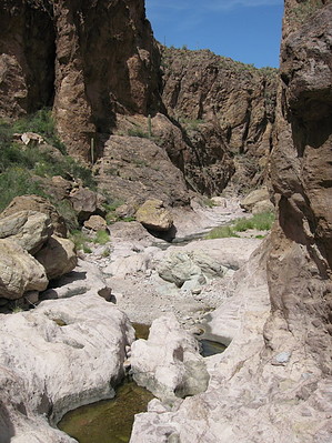
A Diamond in the Rough Superstitions by AZLOT69  First Water Creek has its origins in the Superstitions and is a major drainage. This will be evident as you observe recent levels obvious by large amounts of debris high on the banks and in the trees. Caution should be used during stormy conditions. Watch for flash flooding. A GPS unit is a great help on this hike to keep you in First Water Creek. First Water Creek has its origins in the Superstitions and is a major drainage. This will be evident as you observe recent levels obvious by large amounts of debris high on the banks and in the trees. Caution should be used during stormy conditions. Watch for flash flooding. A GPS unit is a great help on this hike to keep you in First Water Creek.This adventure begins at the horse trailer lot, the first large parking area on the left a couple miles east of SR 88. There is a restroom in the parking lot. Hike east on the road about a hundred yards, to an old jeep road which heads northeast marked "Police Vehicles Only". Take this trail, which will lead you downhill by the old remains of First Water Ranch. Continuing past the ranch, a trail swings south. At this point, the bushwhack begins. Find an opening in the fence, cross into First Water Creek and head north in the creek. Pick and choose your route and follow the creek over smooth rock often pooled with water. As the canyon closes in, the boulders get bigger, and the cliff sides draw your curiosity to the enclaves and balanced rocks. The creek makes a slight turn to the northeast, and you can locate a trail on the right bank. Following this for a short distance brings you to an open area, nice for camping. Hackberry Spring is on your right at the base of the rock face. Hackberry Spring is a reliable source of water year-round and is tapped with an iron pipe.
You will encounter some side canyons that beg for exploring, intersecting from time to time. When water is running, it's easy to determine First Water Creek. Go with the flow of the water. If you look at the side canyons, all flow into First Water Creek, headed for Canyon Lake. If the side canyon is going up in altitude, you took the wrong route. The Canyon gets tighter and tighter, narrowing to perhaps thirty feet in width with towering cliffs on either side. Arches and House sized boulders are plenty but easy to navigate. Eventually, the canyon opens up, and THIS WASH ON YOUR LEFT IS YOUR EXIT to return to civilization. At GPS coordinate - N33 32.028 W 111 26.876 - there is a huge rock dead center in the creek bed. You may notice a rock cairn on the right side of this rock(notice because there have been no rock cairns the entire trip). Look at the left bank of the creek at this point. There is a large lichen-covered rock on the left bank with a large rock cairn on it also. You can continue down First water Creek at this point to explore, but in less than a half-mile, you will come to Canyon Lake, and the only way out is to have someone pick you up in a boat or swim to the first one-way bridge located at Canyon Lake. So, return after exploring the aforementioned coordinates and start up the wash to the west on the left side of the wash. In about a hundred feet, you will pass through the Wilderness Boundary fence and cross over to the wash's right side. A few rock cairns will now guide you out of the canyon as the trail crosses back and forth thru the wash up. You will see power lines and perhaps a car passing on the Apache Trail a short way up. As remote as you feel on this trip, in reality, you are only a few hundred yards from the Apache Trail the whole time. Unfortunately, your wilderness experience is almost complete. Although there's plenty of daylight left, why not make the return trip. If, however, you are going to call it a day, continue to the top, and you can catch your ride or shuttle set up in advance because you come out to the pavement at exactly milepost 208, where there is room for several cars to park. Look back to the east at what some people refer to as the "Little Alps". A special note-in all but the driest time of year, you will get wet on this hike. In the narrow gorges, you should plan on navigating some waist deep water for a short distance. Right now seldom seen but destined to be a Superstition Classic. Check out the Official Route and Triplogs. Leave No Trace and +Add a Triplog after your canyon trip to support this local community. | |||||||||||||||||||||||||||||||||||||||||||||||||||||||||||||||||||||||||||||||||||||||||||||||||||||||||||||||||||||||||||||||||||||||||||||||||||||||||||||||||||||||||||||||||||||||||||||||||||||||||||||||||||||||||