Route Editor

| Guide | ♦ | 36 Triplogs | 1 Topic |
details | drive | no permit | forecast | 🔥 route |
stats |
photos | triplogs | topic | location |
| 450 | 36 | 1 |
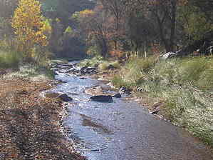
Into the wild, sort of... by cabel   This is an easy and enjoyable hike that follows a creek bed through a canyon for almost the entire way. One word of caution, it can be used by ATV people on the weekend however we had it all to ourselves. Part of the fun is just getting to the start. The last 2 miles need to be with a high clearance vehicle. Park before the Forest road begins a STEEP decline to the creek. This is the only elevation of the entire trip. Beautiful reddish cliffs close in on you as you begin the hike. You can stay in the creek bed for the entire trip or follow the Jeep trail that cuts back and forth. Keep your eyes open for wildlife! We saw plenty of deer and prints of turkey, mountain lion, and bear. The creek flows well but is never deep. This is an easy and enjoyable hike that follows a creek bed through a canyon for almost the entire way. One word of caution, it can be used by ATV people on the weekend however we had it all to ourselves. Part of the fun is just getting to the start. The last 2 miles need to be with a high clearance vehicle. Park before the Forest road begins a STEEP decline to the creek. This is the only elevation of the entire trip. Beautiful reddish cliffs close in on you as you begin the hike. You can stay in the creek bed for the entire trip or follow the Jeep trail that cuts back and forth. Keep your eyes open for wildlife! We saw plenty of deer and prints of turkey, mountain lion, and bear. The creek flows well but is never deep.It was neat to have cactus on one side and lush green reeds on the creek banks. Fall is a beautiful time of year for this hike as Cottonwoods line the creek most of the way. At 3 miles in, the creek goes underground all at one time. Which leaves you the next mile walking through a deep sandy wash that leads to the Verde River. You could ford the river here and hook up with Verde River Trail #11 and make this a very long loop or even a backpacking trip. The river is very fast flowing at this point and one should use caution if attempting to cross. I would filter any water before drinking. This reminds me of a hike through Sedona but with less hassle of getting there. There are a few deep pools that you could soak in but nothing big enough to swim in. If you can avoid the ATVs and have it all to yourself, this is one of the most beautiful trips close to Phoenix. Check out the Official Route and Triplogs. Leave No Trace and +Add a Triplog after your hike to support this local community. | |||||||||||||||||||||||||||||||||||||||||||||||||||||||||||||||||||||||||||||||||||||||||||||||||||||||||||||||||||||||||||||||||||||||||||||||||||||||||||||||||||||||||||||||||||||||||||||||||||||||