Route Editor

| Guide | ♦ | 21 Triplogs | 0 Topics |
details | drive | no permit | forecast | 🔥 route |
stats |
photos | triplogs | topics | location |
| 77 | 21 | 0 |
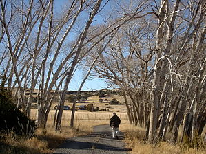
Where the elk and antelope play by azbackpackr   This area off 260 near the Eagar Town Dump has recently been developed with a new trail by the Game and Fish Dept. It was once a working ranch, has gone through several governmental layers of ownership, but now is managed by Game and Fish to provide feed for elk, deer, antelope, and other wildlife, and also I think they are raising some sort of endangered fish in the many ponds there. They irrigate the old fields and raise hay for the wildlife. I often see elk and antelope if I go early enough in the morning. On this last hike we saw a bald eagle, but no large animals. This area off 260 near the Eagar Town Dump has recently been developed with a new trail by the Game and Fish Dept. It was once a working ranch, has gone through several governmental layers of ownership, but now is managed by Game and Fish to provide feed for elk, deer, antelope, and other wildlife, and also I think they are raising some sort of endangered fish in the many ponds there. They irrigate the old fields and raise hay for the wildlife. I often see elk and antelope if I go early enough in the morning. On this last hike we saw a bald eagle, but no large animals.Many long hikes can also be started here. Even a backpacking trip could be started here if one wants to explore the grasslands, although you might want to inform G&F why you're leaving your car there. You can hike through the ranch and up above it and hike to Green's Peak, off-trail, or following old two-track roads. A person could hike for days in the grasslands. Mountain bike rides started here can go for miles on two-track, into the grasslands.
There are no signs to get to this place. From Eagar, you drive west on 260 until, past 261, but before South Fork, you'd turn right, or north, on the road to the Refuse Disposal Site. Once on this road take the first left onto a good gravel road. Follow it in a couple of miles to a locked gate. You'll see the parking area with G & F kiosk. The loop trail starts here, or you can walk on the road. Topo maps: Springerville NW, Greer, Springerville, Eagar. Gate Policy: If a gate is closed upon arrival, leave it closed after you go through. If it is open, leave it open. Leaving a closed gate open may put cattle in danger. Closing an open gate may cut them off from water. Please be respectful, leave gates as found. The exception is signage on the gate directing you otherwise. Check out the Official Route and Triplogs. Leave No Trace and +Add a Triplog after your hike to support this local community. | ||||||||||||||||||||||||||||||||||||||||||||||||||||||||||||||||||||||||||||||||||||||||||||||||||||||||||||||||||||||||||||||||||||||||||||||||||||||||||||||||||||||||||||||||