Route Editor

| Guide | ♦ | 47 Triplogs | 0 Topics |
details | drive | no permit | forecast | 🔥 route |
stats |
photos | triplogs | topics | location |
| 867 | 47 | 0 |
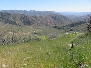
Old man Reavis route by OhOh7   While there are several Reavis hikes on HAZ this is historical and part of the 800 mile Arizona Trail from Mexico to Utah. It is historically significant as it was the closest settlement in the late 1800s where Elisha Reavis could take his produce from his ranch to sell. There is no easy way into Reavis Ranch. An old wagon road (a 9 mile plus hike), since mostly grown over, from the north that starts from an Apache Lake overlook, plus an approach from the south taking FR 172 and 172A for about 14 miles on the extremely rough road followed by a 6.1-mile hike down Rogers Trough and up over a ridge and down to the ranch. While there are several Reavis hikes on HAZ this is historical and part of the 800 mile Arizona Trail from Mexico to Utah. It is historically significant as it was the closest settlement in the late 1800s where Elisha Reavis could take his produce from his ranch to sell. There is no easy way into Reavis Ranch. An old wagon road (a 9 mile plus hike), since mostly grown over, from the north that starts from an Apache Lake overlook, plus an approach from the south taking FR 172 and 172A for about 14 miles on the extremely rough road followed by a 6.1-mile hike down Rogers Trough and up over a ridge and down to the ranch.The question remains, did Reavis want his ranch that out of the way, or was the site the most conducive to growing his produce. It is said to be the only place in the Superstitions to have guaranteed water year around. Anyway, from 1874 until he died in 1896, Elisha Reavis did take lots of his produce from his ranch to Rogers Trough and then down trail 509 over Montana Mountain and on down the creek bed to what is now Superior. Hence the name Reavis Trail Canyon. Originally the settlement was called Hastings until the Army established Picketpost, then the area was called Camp Pinal and Pinal City, and finally Superior from 1900 on. The largest silver mine in Arizona was located here. For a while, it was quite a boomtown.
Our group of 15 met just off highway 60 at about 9 AM. The temperature was in the 40s and a very cold wind was blowing. We drove for 5 miles to a turnout where we could park. We bundled up from the cold and wind and then went north up Whitford Canyon until a jeep road took off to the right and the trail sign indicated the trailhead for 509 and a large sign describing this part of the Arizona Trail. We hiked up the Reavis trail Canyon until we reached a bleachers type formation where we had lunch before returning. From the lunch site, the Reavis Canyon Trail starts its climb for just over a mile up over Montana Mountain and drops down to Rogers Trough. The hike is scenic with rolling hills and lots of vegetation. The area is quite geologically different from the western Superstition cliffs and hoodoos. It still is a wonder how Reavis was able to get his produce down that trail with many creek crossings. I will try to give the best directions I can to get to this trail. From where we parked it was an 8-mile round trip. I would rate it moderately as there are some grades when one leaves the creek bed. I also mentioned that this is a small section of the Arizona Trail. Another obvious indication that you are on the Arizona trail is that there are many, many cairns along the route and most are quite major in size with piles of stones up to 3 feet high like a series of miniature castles to guide your way! This is not a spectacular hike with drop-offs, crags, and spires but it is a very interesting one that has history and one then knows you have been on a bit of the actual Arizona trail. The hike time is about 6 hours RT including lunch. When approaching Montana Mountain one can see the path of an old wagon road high up along the mountain that ultimately comes down to highway 60 near Oak Flat. You also will see some fences, an old rock corral with a fallen down metal shack, and even a ranch area with a ranch house and corral with a fenced area. People say it still is in use but I could not see much evidence of it. Lots of history in this area. Check out the Official Route and Triplogs. Note This is a moderately difficult hike. Leave No Trace and +Add a Triplog after your hike to support this local community. | ||||||||||||||||||||||||||||||||||||||||||||||||||||||||||||||||||||||||||||||||||||||||||||||||||||||||||||||||||||||||||||||||||||||||||||||||||||||||||||||||||||||||||||||||||||||||||||||||||||||