Route Editor

| Guide | ♦ | 49 Triplogs | 2 Topics |
details | drive | no permit | forecast | 🔥 route |
stats |
photos | triplogs | topics | location |
| 513 | 49 | 2 |
Canyons are inherently risky. Flash floods occur without notice on sunny days. Technical skills & surrounding topography knowledge required yet does not eliminate risk.
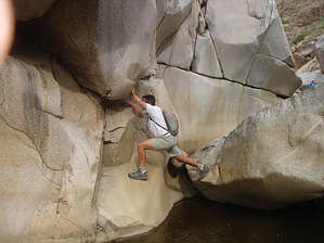
Pools vs. bouldering by hikeaz   Warning WarningNarrow canyons are deadly in the event of a flash flood. The 2020 Brush Fire makes this canyon susceptible to powerful flooding through 2024. Prologue For those of you who have hiked the section of the Agua Fria south of Badger Springs, this is a similar hike, only longer. This was an exploratory hike for all of us. We started at the new boondoggle gate at the Bushnell Tanks turnoff from the Beeline. Making our way down the dirt road (FR22), we passed the various campsites that now appear unused. After about 1 mile, we turned off and followed the Sycamore Creekbed instead of taking the road up onto the hillside. Making our way down the creek was a bit tiring.... up onto boulders, back down again, through the catclaw, around the cockleburrs.... repeat.
As we made our way down-canyon we noticed an old gaging station on creek right. Once past the gaging station, we saw no signs of humans, other than the debris that headed downcanyon in a flashflood, until we neared the end. The further downstream we proceeded, the better the canyon became. We passed massive outcroppings of granite in all shapes, colors, and sizes. This hike was getting good! As you can imagine, there is no trail or route in this canyon; we just crossed the creek, boulder-hopped awhile, pulled out a few thorns, and then switched sides and repeated. The deeper into the canyon we went, the bigger the boulders became, and, in some instances, some exposure had to be dealt with in down-climbing from these boulders and walls. There are tons of waterfalls and swimming holes in this deep section, and it is amazingly beautiful. Some of the granite, as will be the case in creeks, has been polished, and is slippery, especially when wet. Be careful! In a few areas, some "figuring" was required to avoid the need to swim. Sometimes we climbed up-and-around and in other cases, some fun bouldering "moves" served us better. If the weather had been warmer, the hike would have gone quicker, as we would have just plowed/swam through the pools vs. bouldering around them - BOTH are fun, however. After about 3.5 hours in the canyon it widens out and we started to see a few footprints here-and-there. To us, this was signaling our arrival near our finishing spot. As it was, we hiked about another 40 minutes once the canyon flattened/widened out to our awaiting shuttle vehicle that we had dropped off pre-hike. Notes: A+ for adventure. This should likely be called a canyoneering trip vs. a "hike", although it is not technical. Catclaw abounds, dress accordingly. Your time to hike this canyon could vary greatly from ours - know your limits. Due to the willows and other branches being bent downstream, not to mention the 1000' change in elevation between trailheads, I would recommend that be the preferred direction of travel. Thanks to my good friend, Tim, for suggesting the route, and to him, Randy, and Lyle for being the best hiking buddies a guy could ask for - and allowing me to accompany them on this hike. Gate Policy: If a gate is closed upon arrival, leave it closed after you go through. If it is open, leave it open. Leaving a closed gate open may put cattle in danger. Closing an open gate may cut them off from water. Please be respectful, leave gates as found. The exception is signage on the gate directing you otherwise.
Check out the Official Route and Triplogs. Leave No Trace and +Add a Triplog after your canyon trip to support this local community. | |||||||||||||||||||||||||||||||||||||||||||||||||||||||||||||||||||||||||||||||||||||||||||||||||||||||||||||||||||||||||||||||||||||||||||||||||||||||||||||||||||||||||||||||||||||||||||||||||||||||||||||||||||||||||||||||