username
X
password
register
for free!
help
 This is likely a great time to hike this trail!  Check out "Preferred" months below, keep in mind this is an estimate.
  

Salmon Mountain Trail #787, OR

Guide 1 Triplog  0 Topics
  0 of 5  
Fav
Wish
0
details
drive
permit
forecast
map
stats
photos
triplog
topics
location
7 1 0
Statistics
tap row or icons for details
Difficulty 1 of 5
Distance Round Trip 10.2 miles
Trailhead Elevation 4,229 feet
Elevation Gain 550 feet
Kokopelli Seeds 12.95
unreported if dogs are allowed
editedit > ops > dogs to adjust
feature photo
Photos Viewed All MineFollowing
7  2020-06-14
Twin Springs TH to Salmon Mountain
keepmoving
Author
author avatar Guides 16,843
Routes 17,472
Photos 24
Trips 1 map ( 6 miles )
Age 28 Male Gender
Location HAZ, TrailDEX
Associated Areas
list map done
North Central Region
Historical Weather
Trailhead Forecast
Expand Map
Preferred Aug, Jul, Sep, Jun
Sun  5:34am - 6:38pm
0 Route
 
1 Alternative


remove free decal offer

 Likely In-Season!
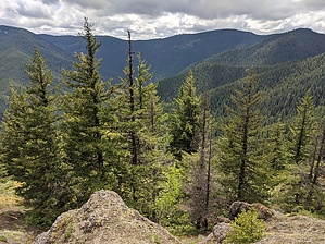
This trail enters the Salmon-Huckleberry Wilderness. The trail crisscrosses the ridgeline to an abandoned lookout. There are outstanding views of the nearby peaks, the Cascades, and the Salmon River Drainage at the lookout. Rarely visited, it is a good place for solitude. The trail is narrow and rocky.


This trail begins at Plaza Trail #783 and ends at an abandoned lookout near the summit of Salmon Mountain. From Plaza Trail #783 (3,840’), the trail follows a ridge with the occasional steep pitch. The trail is rocky with no tread between 0.9 mile and 1.3 miles. The trail makes a switchback up to the lookout (4,000’) at 1.6 miles.
  • Salmon Mountain Trail #787 Map
    guide related
    Salmon Mountain Trail #787 Map


Check out the Triplog.
Leave No Trace and +Add a Triplog after your hike to support this local community.
WARNING! Hiking and outdoor related sports can be dangerous. Be responsible and prepare for the trip. Study the area you are entering and plan accordingly. Dress for the current and unexpected weather changes. Take plenty of water. Never go alone. Make an itinerary with your plan(s), route(s), destination(s) and expected return time. Give your itinerary to trusted family and/or friends.

 Permit $$
no fees or permits reported

if incorrect tell us about it

Mount Hood Forest
more info


 Directions
or
 Road


To hike
From Hood River, OR - follow Oregon Hwy 35 38.5 miles and merge right onto US Hwy 26. Follow US Hwy 26 8.9 miles south and turn right (west) at Skyline Road (Forest Road 42). Follow Skyline Road for 1.1 miles and turn right toward Forest Road 2660. Travel 2.5 miles and turn left (southwest) to stay on Forest Road 2660 and continue another 0.9 miles. Turn right at Abbott Road (Forest Road 58) and travel 10.7 miles. Take the right fork at Forest Road 4610 (near High Rock-the road becomes dirt here) and follow it for 8.3 miles to the small parking area and trailhead on the north side of the road.

From Estacada, OR - follow Oregon Hwy 224 (Clackamas Hwy) south for 6.5 miles to N Fork Road (Forest Road 4610). Travel 7.1 miles and stay left on N Fork Road (Forest Road 4610). After 0.9 miles take the first right onto Abbott Road (Forest Road 4610). Follow Abbott Road (Forest Road 4610) for 11.1 miles to the small parking area and trailhead on the north side of the road. Follow Plaza Trail #783 for 3.1 miles north to the beginning of this trail.
page created by HAZ_Hikebot on Mar 09 2010 6:42 pm
 90+° 8am - 6pm kills
helpcorrectionissue

end of page marker