username
X
password
register
for free!
help


Sugarloaf Mtn - Bullhead City, AZ

Guide 7 Triplogs  0 Topics
  2 of 5  
Fav
Wish
0
details
drive
no permit
forecast
route  
stats
photos
triplogs
topics
location
53 7 0
Statistics
tap row or icons for details
Difficulty 2.5 of 5
Route Finding 2 of 5
Distance Round Trip 1 mile
Trailhead Elevation 2,620 feet
Elevation Gain 630 feet
Accumulated Gain 630 feet
Avg Time Round Trip 1 hour
Kokopelli Seeds 4.15
 Interest Off-Trail Hiking & Peak
 Backpack Possible - Not Popular
unreported if dogs are allowed
editedit > ops > dogs to adjust
feature photo
Photos Viewed All MineFollowing
4  2018-04-20 mt98dew
9  2015-11-13 azbackpackr
13  2011-09-15 Stoic
18  2011-09-13 Stoic
9  2005-11-27 slegal
Author
author avatar Guides 77
Routes 106
Photos 2,987
Trips 57 map ( 363 miles )
Age 63 Male Gender
Location Thousand Oaks, CA
Associated Areas
list map done
Northwest Region
Historical Weather
Trailhead Forecast
Radar Map
Expand Map
Preferred Mar, Nov, Apr, Feb
Seasons   Late Autumn to Early Spring
Sun  6:13am - 6:59pm
Official Route
 
0 Alternative


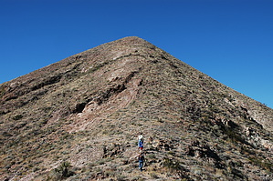
Short and steep
by slegal

 
There is more than one Sugarloaf Mountain in Arizona. This one is just off Highway 68 between Bullhead City and Kingman. There are no trails to the top of Sugarloaf, but route finding isn't difficult and vegetation is sparse enough that it isn't a bushwhack either.


I discovered Sugarloaf while in Laughlin for an 80th birthday celebration for my father-in-law. I was looking for a fun hike that would be strenuous and challenging, but not too strenuous and challenging for my then 10-year-old son. I found the mountain by looking for a hike through Geocaching.com. There is a geocache at the top of the mountain called "Pirates at the Peak". In looking at the topo map, the hike looked perfect for everyone that would be going on this particular hike with me.
remove free decal offer
To find Sugarloaf Mountain take Highway 68 to the turnout to the Old Kingman Highway. Upon leaving Highway 68 Sugarloaf will be on your left side. You will see a smaller dirt road to your left and another quick left turn to get to a good parking place or you can park just off Highway 68 and make a longer hike of it. From the trailhead we used you are looking straight up Sugarloaf and a 585 foot climb. It's very steep and slippery from about halfway up to the top.

Once you're at the top, you are rewarded with spectacular views of Lake Mohave and the surrounding mountains. Some of the mountains to the south of Sugarloaf appear to offer some pretty incredible adventures as well.

The return trip down Sugarloaf is the tough part in my opinion. Even with good hiking boots on, I still managed to slip and fall twice. Maybe I should have been wearing sneakers like everyone else.

2007-02-16 slegal


    Check out the Official Route and Triplogs.
    Leave No Trace and +Add a Triplog after your hike to support this local community.
    WARNING! Hiking and outdoor related sports can be dangerous. Be responsible and prepare for the trip. Study the area you are entering and plan accordingly. Dress for the current and unexpected weather changes. Take plenty of water. Never go alone. Make an itinerary with your plan(s), route(s), destination(s) and expected return time. Give your itinerary to trusted family and/or friends.

     Permit $$
    None


     Directions
    or
     Road
    FR / Dirt Road / Gravel - Car Okay

    To hike
    From Bullhead City take Highway 68 east about 8.5 miles to the turnout to the Old Kingman Highway. From Kingman take Highway 93 northwest to Highway 68 west. It is about 26.3 miles from Kingman to the turnout to the Old Kingman Highway.
     90+° 8am - 6pm kills
    helpcorrectionissue

    end of page marker