Route Editor

| Guide | ♦ | 42 Triplogs | 0 Topics |
details | drive | permit | forecast | 🔥 route |
stats |
photos | triplogs | topics | location |
| 293 | 42 | 0 |
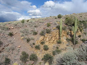
There's Gold in Them Hills by AZLOT69  History HistoryDating back to 1886, the Palmer mine was originally known as the Boulder-Buckhorn Mine, high on the slopes of the western face of the Superstition Mountains. William Kimball was the original owner, and he sunk a shaft 75 feet deep, uncovering Gold and Copper. William Kimball died in 1906 from pneumonia. The mine sat inactive until 1917. Dr. Ralph Palmer was an investor with a group from Mesa, and they extended the shaft to a depth of 215 feet, but World War 1 eventually caused the mine to become inactive again. The mine had a note against it and was eventually sold at auction in 1926. Dr. Palmer became the sole proprietor. A drift was extended another 35 feet, and Palmer was sure he was close to a rich vein of Gold. After the substantial investment, mining operations came to an abrupt end in 1947 after an accident claimed an employee's life some 225 feet below ground. The Mine was abandoned in 1949. Dr. Palmer was an Arizona pioneer, and his love for mining and the Superstition Mountains intrigued him until he died in 1954. With a little history in hand, here's a nice loop hike which gets you up close to the Superstitions, at a height offering spectacular views of the valley, can be accomplished in a morning or afternoon and is within most people's abilities.
(If you wanted to avoid the State Park Fee, this would be an alternate way to approach this loop, but it adds significantly to the distance. You could park at the Broadway Trailhead and hike north on Jacobs Crosscut. This adds 4.5 miles one way, or you could park off First Water and hike over on Jacobs Crosscut, adding about 2 miles one way.) Continue towards the mountains on the Siphon Draw Trail, and soon you will see what's left of a small structure on your left with a concrete cellar... continue on about 200 feet, and you will see a trail curving off to the left. This is your turn. Soon you can see that this was an old jeep/service road. In about a hundred yards, you will see a house-sized boulder on your left, painted - KEEP OUT - on it just begging for you to continue. Now you will begin to notice Mine Tailings. These Mine Tailings continue for about a city block. Take your time thru this area and explore the hillsides. Look up at the hoodoos. Notice bits of Copper Ore all around you( blue-green color). Try to imagine where the shaft was located. You will find various pieces of metal and pipe still in the dump area. As you continue to the north on this trail, you will come to another digging a few feet off the trail to the east, in which you can see a few copper veins in the rock. The trail continues to the north and passes thru a couple of steep washes. Suddenly you arrive at a trail. This is the Prospectors View Trail. You have options here, but my loop continues by taking a left at this unmarked intersection and following it down to a marked junction with Jacobs Crosscut. Here I turned right and Continue to the north now on Jacobs Crosscut. Proceed about 1/3 mile thru a couple of passes, enjoying your view of Four Peaks. There is a small trail marked by a Cairn, which heads off to the Northwest at this point. Take this trail, and it arrives back to the Saguaro parking lot where there are restroom facilities. Then continue Northwest on the trail - mile to your start- The Siphon Draw Trailhead. Gate Policy: If a gate is closed upon arrival, leave it closed after you go through. If it is open, leave it open. Leaving a closed gate open may put cattle in danger. Closing an open gate may cut them off from water. Please be respectful, leave gates as found. The exception is signage on the gate directing you otherwise.
Check out the Official Route and Triplogs. Leave No Trace and +Add a Triplog after your hike to support this local community. | ||||||||||||||||||||||||||||||||||||||||||||||||||||||||||||||||||||||||||||||||||||||||||||||||||||||||||||||||||||||||||||||||||||||||||||||||||||||||||||||||||||||||||||||||||||||||||||||||||||||||||||||||||||||||