username
X
password
register
for free!
help
  This is likely a great time to hike this trail!  Check out "Preferred" months below, keep in mind this is an estimate. 
   🔥

West Spruce Trail #264, AZ

Guide 26 Triplogs  1 Topic
  3.8 of 5  
Fav
Wish
2
details
drive
permit
forecast
🔥
route  
stats
photos
triplogs
topic
location
244 26 1
Statistics
tap row or icons for details
Difficulty 2.5 of 5
Route Finding 1 of 5
Distance One Way 11.86 miles
Trailhead Elevation 6,639 feet
Elevation Gain -1,504 feet
Accumulated Gain 1,666 feet
Avg Time One Way 5 hours
Kokopelli Seeds 17.41
 Interest Peak
 Backpack Yes & Connecting
feature photo
Photos Viewed All MineFollowing
Will recalculate on button tap!
6  2025-04-26 Whiffer
1  2024-11-09
Trails #393 744 and 264
Whiffer
2  2024-08-03
High Valley Ranch 9401J & West Spruce
Whiffer
10  2024-05-17
Thumb Butte - Mt Francis Loop
The_Eagle
13  2024-05-17
Thumb Butte - Mt Francis Loop
joebartels
8  2022-05-21 Whiffer
5  2022-02-19 Whiffer
13  2021-11-02
Williams - West Spruce
DixieFlyer
Page 1,  2
Author
author avatar Guides 170
Routes 148
Photos 5,914
Trips 2,097 map ( 11,156 miles )
Age 48 Male Gender
Location Tucson, AZ
Associated Areas
list map done
Prescott Region
Historical Weather
Trailhead Forecast
Radar Map
Expand Map
Preferred May, Oct, Sep, Apr → 8 AM
Seasons   Early Spring to Early Winter
Sun  6:05am - 6:53pm
Official Route & 4 Rts
 
14 Alternative
 
Historic Fire Perimeteracres
🔥 2018 Stubbs Fire34.7 mi**


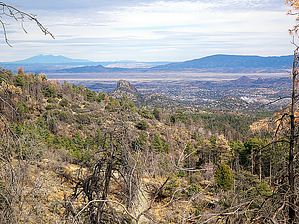
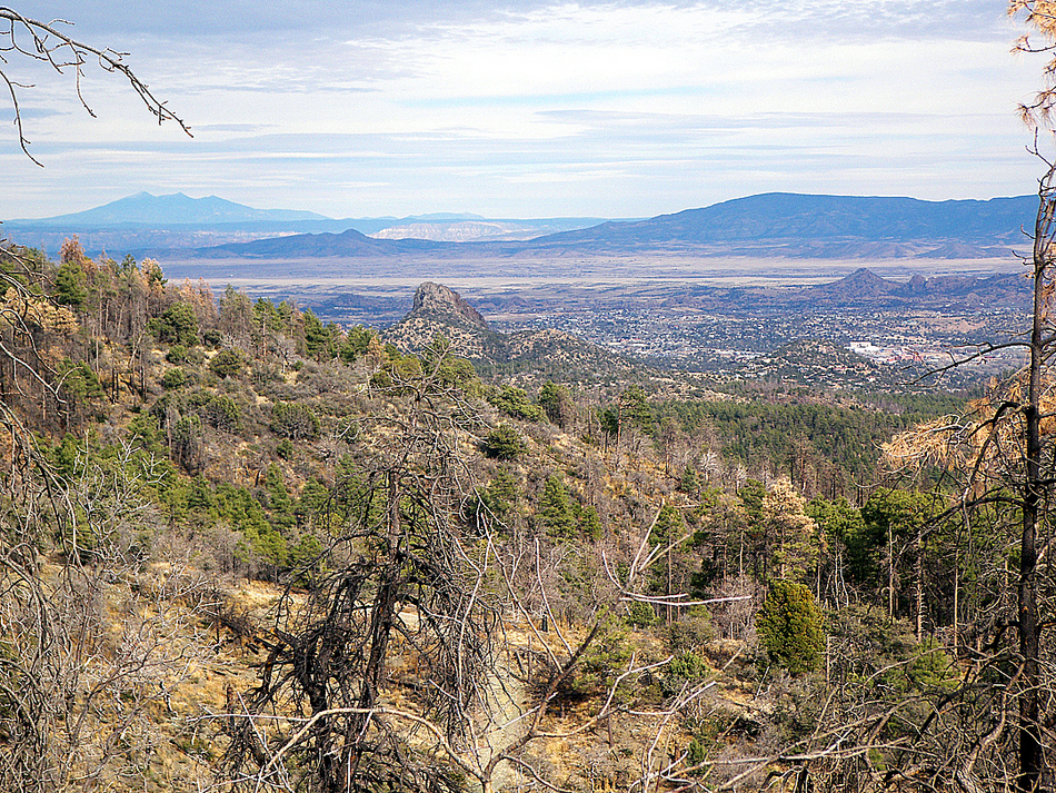
Away up high in the Sierry Petes
by PrestonSands

  Likely In-Season! 
2024
East extended 3.35 miles.

Note
The description is for the east half, stats are for the full trail segment. Co-Author for the west half is open.


The West Spruce Trail #264 follows the crest of the northern Sierra Prieta mountains west of Prescott. It is made up of two unconnected segments: the west half and the east half. This description is of the east half. Views, cool forest country and 7160 foot West Spruce Mountain are the attractions on this peaceful trail. West Spruce Mountain is named for its stand of douglas fir trees, which early settlers in this region misidentified as spruce. The Sierra Prieta peaks, of which West Spruce Mountain is a part, were made famous in the poem "Sierry Petes (Or Tying The Knots In The Devil's Tail)", by Prescott cowboy Gail Gardner.
remove free decal offer
Beginning at the trailhead just north of the Sierra Prieta overlook, start heading up the trail on the east side of the ridge as it parallels county road 65. The trail soon reaches the top of the ridge, passing a gigantic old alligator juniper along the way. Arriving at a saddle below a brush-covered outcropping of weathered granite, wonderful views of Copper Basin, Skull Valley, and distant mountain ranges open up to the west. Other points along the trail feature great views of Granite Mountain, Thumb Butte, and the San Francisco Peaks.

At about the 0.66-mile mark, the first of several side trails to the east appear; this one goes to fire-damaged William's Peak. Keep left and follow the ridgeline when encountering these side trails to stay on the West Spruce Trail. Beyond this unmarked junction, the trail continues through the ponderosa and Gambel oak forest, and begins a steady descent to its lowest point, in a 6600-foot saddle. The West Spruce Trail contours along the 6600-foot level for a while, before starting to climb again around mile 2. At this point, you will encounter the first of an increasing number of douglas fir trees, on a shady uphill stretch. At the top of this little hill, 7000 foot Porter Mountain comes into view ahead. The trail now traverses the top of a steep brushy ridge, where the occasional interspersed Douglas-firs seem out of place.

The trail crosses two more small saddles before making a 300-foot climb to the top of an unnamed, flat-topped mountain, slightly southwest of Porter Mountain. Once on top, the West Spruce Trail passes the junction with trail #300 and crosses over the top of a gully before contouring along the eastern slope of West Spruce Mountain itself. For those wanting to reach the summit of West Spruce Mountain, it is a short off-trail hike up the slope on your left.

The east half of the West Spruce Trail soon comes to an end at forest road 47B. Should you wish to continue, the west half of the West Spruce Trail is reportedly a 1.4-mile hike to the west down forest road 47B.

2007-03-02 PrestonSands


    Check out the Official Route and Triplogs.
    Leave No Trace and +Add a Triplog after your hike to support this local community.

    One-Way Notice
    This hike is listed as One-Way.

    When hiking several trails on a single "hike", log it with a generic name that describes the hike. Then link the trails traveled, check out the example.
    WARNING! Hiking and outdoor related sports can be dangerous. Be responsible and prepare for the trip. Study the area you are entering and plan accordingly. Dress for the current and unexpected weather changes. Take plenty of water. Never go alone. Make an itinerary with your plan(s), route(s), destination(s) and expected return time. Give your itinerary to trusted family and/or friends.

     Permit $$
    None

    Prescott Forest
    Prescott National Forest Pass

    Only trailheads with six "amenities" have fees. Amenities are picnic tables, trash, toilet, parking, interpretive signing and security.


     Directions
    or
     Road
    FR / Dirt Road / Gravel - Car Okay

    To hike
    From Highway 69/Highway 89 junction in Prescott, take Gurley Street west for 1.25 miles, then turn left (south) on Montezuma Street (Highway 89). Follow Montezuma Street south, then west for 1.0 miles to the traffic light at Copper Basin Road. Turn right onto Copper Basin Road (County Road 64), and follow it about 6 miles to the junction with County Road 65. Turn right onto County Road 65 (to the Sierra Prieta Overlook), and follow it about 1.35 miles to the trailhead. The trailhead is on the left, about 0.4 miles past the Sierra Prieta Overlook, and right as the road leaves the steep mountainside behind. There is a brown carsonite trail marker that reads 264 near the beginning of the trail.
     90+° 8am - 6pm kills
    helpcorrectionissue

    end of page marker