Route Editor

| Guide | ♦ | 1 Triplog | 0 Topics |
details | drive | permit | forecast | route |
stats |
photos | triplog | topics | location |
| 18 | 1 | 0 |
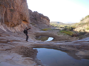
Magic and Dinosaurs by rvcarter “There is a place in Far West Texas where night skies are dark as coal and rivers carve temple-like canyons in ancient limestone. Here, at the end of the road, hundreds of bird species take refuge in a solitary mountain range surrounded by weather-beaten desert. Tenacious cactus bloom in sublime southwestern sun, and diversity of species is the best in the country. This magical place is Big Bend.” Some creative “ad agency” writing from the NPS web site for Big Bend National Park. Despite the flowery prose, I know first hand that there are lots of great hiking in BBNP, mostly in the Chisos Mountains but also in the Boquillas and Santa Elena Canyons, and a few other places. Slickrock Canyon is not promoted as a recommended hike by the National Park Service at Big Bend National Park. Neither is it shown on most topo maps as a distinct geologic feature (but if you’re looking, check between Slickrock Mountain and Croton Peak). It isn’t mentioned on most web sources of hiking information, and the routes suggested in the few books I found that even mentioned the feature were off base. So... here is the straight poop.
There is no trail to or from Slickrock Canyon from anywhere. In fact, I had a hard time finding any trail/route, so I turned my trusted friend: Google Earth. This yielded the mountain, but not the canyon. However, the huge gash in the ridge on the east side of Slickrock Mountain is hard to miss. The meager information available suggested a route that looked like a dogleg route starting from Maverick Drive up a couple of washes. I laid out a few waypoints (see the jpg) starting from a paved pull-off on the north side of the road about a mile east of the Maverick Road/Ross Maxwell Scenic Drive intersection (there is another pull-off about 1000 feet to the NE). However, we soon abandoned the "dogleg right" plan in favor for a Pythagorean approach, i.e., straight to the canyon. Don’t stay in the washes. The terrain is great for hiking and the sandy washes will wear you out. There are a few points where you need to cross washes and wade through some waist-high grass, but it’s easy going with little elevation change and surprisingly good footing. There are a few, easily-avoided thorny bushes along the way. The canyon is clearly visible from high points once you leave the road, just keep hiking straight north. About 600 feet before reaching the canyon, drop into the wash and enjoy the magnificent canyon with walls extending up hundreds of feet. Even in the dry season, there are pools of water and lots of signs of their use by animals in the area. There were two hawks circling above for the whole time we were there. Interesting geology all along the way. Look closely along the way; you might even spot a dinosaur bone. Very nice half-day hike, and you won’t have to stand in line for this one. We didn’t see a single person the whole time. Visit the Fossil Discovery Exhibit, a few miles north of the Panther Junction Visitor Center. Warning This is desert terrain. There is no shade on any part of this hike except in the canyon, and expect any water you find to be polluted with animal feces, etc. The park probably discourages hikers from going to Slickrock Canyon during most of the year for these reasons. Take plenty of liquids. Check out the Official Route and Triplog. Leave No Trace and +Add a Triplog after your hike to support this local community. | |||||||||||||||||||||||||||||||||||||||||||||||||||||||||||||||||||||||||||||||||||||||||