Route Editor

| Guide | ♦ | 7 Triplogs | 0 Topics |
details | drive | no permit | forecast | route |
stats |
photos | triplogs | topics | location |
| 162 | 7 | 0 |
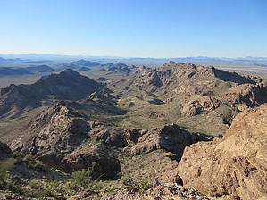
northern accipitridae visual acuity by Jim   Eagle 3186 is the highest point in the northern half of the Eagletail range, eclipsed only by Eagletail Peak at the southern end of the range. Eagle 3186 is a non-technical peak, providing the best views over the range available without climbing gear. This hike provides a decent challenge for desert route finding, cross country travel, and is an excellent way to be alone, but you don't have a forest of cholla or ATV people. Eagle 3186 is the highest point in the northern half of the Eagletail range, eclipsed only by Eagletail Peak at the southern end of the range. Eagle 3186 is a non-technical peak, providing the best views over the range available without climbing gear. This hike provides a decent challenge for desert route finding, cross country travel, and is an excellent way to be alone, but you don't have a forest of cholla or ATV people.The hike is two segments, with the first being the long road walk approach to the catchment. The second is the off-trail approach to the base of the mass of peak 3186. The second segment is more difficult, but it is pretty straightforward to get to. Once at the base, avoid going up to the cliffs and instead go around to the SE face and scramble up to the summit block. For the summit, it should never be too difficult.
Check out the Official Route and Triplogs. Leave No Trace and +Add a Triplog after your hike to support this local community. | ||||||||||||||||||||||||||||||||||||||||||||||||||||||||||||||||||||||||||||||||||||||||||||||||||||||||||||||||||||||||||||||||||||||||||||||||||||||||||||||||||||||||||||||||