username
X
password
register
for free!
help
 This is likely a great time to hike this trail!  Check out "Preferred" months below, keep in mind this is an estimate.
  🔥

Pomeroy Tanks, AZ

Guide 4 Triplogs  0 Topics
  3.5 of 5  
Fav
Wish
0
details
drive
no permit
forecast
🔥
route  
stats
photos
triplogs
topics
location
4 4 0
Statistics
tap row or icons for details
Difficulty 0.5 of 5
Route Finding 1 of 5
Distance One Way 0.45 miles
Trailhead Elevation 6,651 feet
Elevation Gain 62 feet
Accumulated Gain 66 feet
Kokopelli Seeds 0.67
 Interest Seasonal Creek
unreported if dogs are allowed
editedit > ops > dogs to adjust
feature photo
Photos Viewed All MineFollowing
Will recalculate on button tap!
8  2018-08-18
Sycamore Canyon Rim Loop
chumley
12  2017-04-02
Sycamore Canyon Rim Loop
FOTG
4  2017-03-11 arizona_water
18  2014-09-07
Sycamore Canyon Rim Loop
FOTG
Author
author avatar Guides 16,843
Routes 17,472
Photos 24
Trips 1 map ( 6 miles )
Age 28 Male Gender
Location HAZ, TrailDEX
Associated Areas
list map done
Flagstaff Region
Historical Weather
Trailhead Forecast
Radar Map
Expand Map
Preferred Oct, May, Apr, Sep
Sun  6:03am - 6:51pm
Official Route
 
1 Alternative
 
Historic Fire Perimeteracres
🔥 2021 Raphael Fire68.5 mi**


remove free decal offer

 Likely In-Season!
Guide Needed
Publish Full Detail Guide


Use +Add above to share photos and triplogs
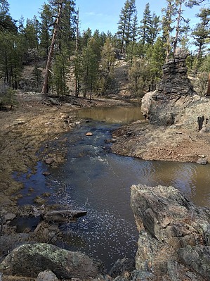
A short connecting trail to the Sycamore Canyon Rim Loop with access to the perennial water of Pomeroy Tanks. Expect the pools to be low in the early summer and late autumn months.


    Check out the Official Route and Triplogs.
    Leave No Trace and +Add a Triplog after your hike to support this local community.

    One-Way Notice
    This hike is listed as One-Way.

    When hiking several trails on a single "hike", log it with a generic name that describes the hike. Then link the trails traveled, check out the example.
    WARNING! Hiking and outdoor related sports can be dangerous. Be responsible and prepare for the trip. Study the area you are entering and plan accordingly. Dress for the current and unexpected weather changes. Take plenty of water. Never go alone. Make an itinerary with your plan(s), route(s), destination(s) and expected return time. Give your itinerary to trusted family and/or friends.

     Permit $$
    no fees or permits reported

    if incorrect tell us about it


     Directions
    or
     Road
    FR / Dirt Road / Gravel - Car Okay

    To hike
    From Flagstaff:
    Take I-40W, then exit for Parks. Drive S on Garland Prairie Rd for 10 miles. Turn N onto Thomas Loop Rd. After one mile, turn W. Continue for three miles until White Horse Lake Rd intersection. Head south on White Horse Lake Rd. A signed parking area for Pomeroy Tanks will be on the left after 2.4 miles.
    page created by arizona_water on Mar 17 2017 10:16 am
     90+° 8am - 6pm kills
    helpcorrectionissue

    end of page marker