Route Editor

| Guide | ♦ | 9 Triplogs | 0 Topics |
details | drive | no permit | forecast | map |
stats |
photos | triplogs | topics | location |
| 10 | 9 | 0 |
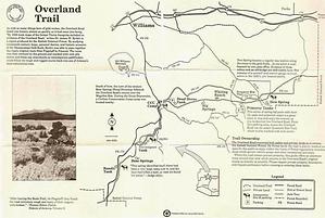
portions are a challenge to follow by HAZ_Hikebot   This route was laid out and built in the summer of 1863 by the Army. It connected the Beale Road with the growing community of Prescott, which experienced a short-lived gold rush. This road left the Beale Road near where Flagstaff is today and continued west through Garland Prairie to Lockett Spring. Then, it turned southwest to cross Hell Canyon and from there south to Prescott. About 30 miles of the route is located on the Kaibab National Forest. The road was used by the military, immigrants, and freighters between 1863 and 1882 when the railroad was built across northern Arizona. As with the Beale Road, much of the Overland Road has been covered over by the present-day Forest Service road system, but portions are still visible. This route was laid out and built in the summer of 1863 by the Army. It connected the Beale Road with the growing community of Prescott, which experienced a short-lived gold rush. This road left the Beale Road near where Flagstaff is today and continued west through Garland Prairie to Lockett Spring. Then, it turned southwest to cross Hell Canyon and from there south to Prescott. About 30 miles of the route is located on the Kaibab National Forest. The road was used by the military, immigrants, and freighters between 1863 and 1882 when the railroad was built across northern Arizona. As with the Beale Road, much of the Overland Road has been covered over by the present-day Forest Service road system, but portions are still visible.Traveling from east to west, one first encounters the wide grasslands of Garland Prairie. Dotted with hardscrabble homesteads, both active and deserted, its vistas still inspire visions of hardy pioneers. Farther along, the old road enters the trees and passes the remains of an old way-station which even boasted its own post office for a time. The foundations of a few cabins are still visible here.
Mountain biking is good on FR 57 between FR 354 and Bear Springs. Horseback riding is recommended anywhere along the trail between FR 141 and FR 139, although it may become rocky in the Pomeroy Tanks area. Trail Layout: The Forest Service has developed the Overland Road into a recreational trail. The route makes use of forest roads and trails which have been marked with rock cairns, brass cap markers, tree blazes, and 4" by 4" wood posts. A treadway has not been cleared on the trail sections, so it can be a challenge to follow. Trailheads with interpretive signs are provided. The trail sections are open only to hikers and horseback riders. Portions of the historic route that are part of the forest road system may be accessed by any means, including motor vehicles and mountain bicycles. Length: 25 miles Hiking Time: A variety of access points provide for hikes of varying length and time. Rating: Easy to moderate. Trailhead Location: There are a variety of trailheads (please see forest recreation map for details). An accessible vault toilet is available at Pomeroy Tanks Trailhead. Recommended Season: Late spring, late fall. Use Restrictions: Travel by motorized vehicles on sections of the Overland Road located off of Forest Service roads, is prohibited. USGS Map: Bill Williams Mtn. SW, Bill Williams Mtn. NE, Garland Prairie Check out the Triplogs. Leave No Trace and +Add a Triplog after your hike to support this local community. | ||||||||||||||||||||||||||||||||||||||||||||||||||||||||||||||||||||||||||||||||||||||||||||||||||||||||||||||||||||||||||||||||||||||||||||||||||||||||||||||