 Route Editor

| Guide | ♦ | 87 Triplogs | 5 Topics |
details | drive | no permit | forecast | 🔥 route |
stats |
photos | triplogs | topics | location |
| 971 | 87 | 5 |
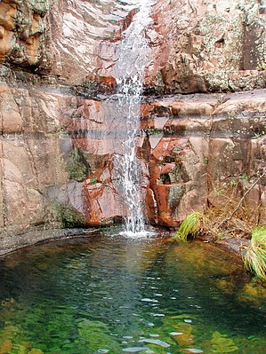
steep trail to Workman creek by te_wa   While many of the more popular areas, such as the Superstitions and the Mogollon Rim, see hordes of people escaping the valley's drama, the Hells Hole area of the Salome Wilderness offers solitude and silence. It starts as a nice stroll up an old jeep road through a pine forest. After 100 ft, you will come to a sign for the Hells Hole Trail-6 miles, Boyer Trail-2 miles. Based on my calculations, the Boyer Trail is 2.5 miles from the T.H., and the Hells Hole Trail is 5 miles. While many of the more popular areas, such as the Superstitions and the Mogollon Rim, see hordes of people escaping the valley's drama, the Hells Hole area of the Salome Wilderness offers solitude and silence. It starts as a nice stroll up an old jeep road through a pine forest. After 100 ft, you will come to a sign for the Hells Hole Trail-6 miles, Boyer Trail-2 miles. Based on my calculations, the Boyer Trail is 2.5 miles from the T.H., and the Hells Hole Trail is 5 miles.When the trail steadily climbs to the top of a shoulder, it then begins moderately descending through forest, including Emory oak, manzanita, and ponderosa, with some juniper thrown in for fun. About 1 mile from the T.H., you come to Armer Ranch. Please respect this private property. At the ranch, the trail turns right (north) following the drainage of Workman Creek for a short distance before dropping into it. It's a well-shaded area with pools of water and larger riparian trees. After crossing the seasonal creek, you will begin a steady and moderate climb past a Salome Wilderness sign to the top of an exposed scrubby hill. Here you will find more dry-climate plantlife, and in October, I spotted several lizards and toads enjoying the rocky trail shaded with large manzanita.
I discovered a way up and around the falls to a spot where the creek cuts its way through pink granite. The going would be slow after this point. It is completely overgrown on one side and has a sheer 40' drop-off on the other. You could also attempt a cross-country bushwack, the mile or so to Salome Creek or farther to the "JUG". Check out the Official Route and Triplogs. Leave No Trace and +Add a Triplog after your hike to support this local community. One-Way Notice This hike is listed as One-Way. When hiking several trails on a single "hike", log it with a generic name that describes the hike. Then link the trails traveled, check out the example. | |||||||||||||||||||||||||||||||||||||||||||||||||||||||||||||||||||||||||||||||||||||||||||||||||||||||||||||||||||||||||||||||||||||||||||||||||||||||||||||||||||||||||||||||||||||||||||||||||||||||||||


