Route Editor


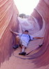
As for flatiron/ridgeline:
• Parking could be an issue. The Lost Dutchman State Park doesn't want overnight parking at the day use area and campsites are $25. Doable, but paying $25 for one person to go hiking is a little steep. Maybe I could round up some other wackos to split the cost a bit. I could park at the Broadway TH, but that adds 4 miles each way to the hike. There is a resturant and residential in the area I might be able to park at, but I'd have to scout it out and hope nothing happens to my car overnight, like getting towed. I could start from the carne springs side, but you don't see as much city lights until you get closer to the flatiron side.
• How much of an issue would snakes be in the Superstitions on warm summer night? I did most of my Superstition hiking back in late Winter & early Spring, so I didn't see or hear a single snake back then.
• Due to the flatiron hike being mostly in that canyon, I'd ideally want to start hiking as the sun is setting, so that I'm not hiking the toughest section with only a headlamp. But in the summer the temps are still in the 100s at sunset and I also wasn't diggin how early the full moon has been rising this month. The moon would probably have set before I was done hiking. So maybe later this summer would be better or maybe next month might look good. But I don't want to wait too long or I'll be freezing up on the ridgeline at night.
Hehe, it just dawned on me what the real issue probably is. I WANT TO DO A REAL HIKE IN THE SUPERSTITIONS AGAIN. :twisted: You know, like a good 15+ miler without having to wait until Fall while it's 110° outside right now in the valley..... Any tips or suggestions would be appreciated.