username
X
password
register
for free!
help
ArticlesGuidesRoutes
 
Photosets
 
 Comments
triplogs   photosets   labels comments more
Mule Canyon - 1 member in 13 triplogs has rated this an average 4 ( 1 to 5 best )
13 triplogs
login for filter options
Feb 02 2017
avatar

 Guides 253
 Photos 6,930
 Triplogs 2,467

75 male
 Joined Nov 05 2008
 Cloudcroft, NM
Mule CanyonSoutheast, NM
Southeast, NM
Canyoneering avatar Feb 02 2017
imikeTriplogs 2,467
Canyoneering2.80 Miles 1,700 AEG
Canyoneering2.80 Miles
1,700 ft AEG
Basic Canyoneering - Scrambling; easy climbing/downclimbing; frequent hand use; rope recommended; easy exit
 no routes
Linked   none no linked trail guides
Partners none no partners
Ross with me checking out N2 cut...not bad! Wandering around up near the cliffs, then exit down N1, entry cut. Easier day leading into Saturday difficult group hike.
_____________________
Ageless Mind... Timeless Body... No Way! Use It and Lose It. Just the way it is...
 
Dec 27 2016
avatar

 Guides 253
 Photos 6,930
 Triplogs 2,467

75 male
 Joined Nov 05 2008
 Cloudcroft, NM
Tuff Slot, NM 
Tuff Slot, NM
 
Canyoneering avatar Dec 27 2016
imikeTriplogs 2,467
Canyoneering7.00 Miles 2,100 AEG
Canyoneering7.00 Miles
2,100 ft AEG
Basic Canyoneering - Scrambling; easy climbing/downclimbing; frequent hand use; rope recommended; easy exit
 no routes
1st trip
Linked   linked  
Partners none no partners
Returning to our exploratory of the cuts on the West end of Burlison Ridge, today we headed over to the small fault towards the north end. Ross commented early on that it did not look as iff we'd be able to make it out the top... It looked beyond steep: cliffed out?

We were approaching from the road to Mule canyon... hopes of looping around and down into the canyon for an easier exit? On the walkover to the mouth of the Slot, Ross spotted what appeared to be a debris field... oddly white. We detoured to check it out. He was right... a Calcite Mine! Oddly abundant veins of white... pit mine down through the deposits. Huge chunks of calcite piled around. Thiss was the first we've seen of such large pieces. Nice.

Moving over to the next cut, we were on the solid bedrock of the Slot... appears to be Tuff flow? Great footing for this steep ascent. The cut had the straight walled defile of a fault, but once into the cut it was much wider than we normally encounter... 20' wide? Interesting rock ... good footing... no blockage. It was work but easy to top out.

Once up we enjoyed the ever increasing vistas opening up in Mule. We continued to ascend the south side ridge... moving up through cliff stratas as we moved deeper into the canyon. We picked a major spur cut and hiked over and down... enjoying a very easy sidehill ridge down to the canyon bottom. Overall... great little loop!

We will go back in and follow the ridge deeper into Mule... ideally connecting with Dead Elk Cut? We also spotted three more north side spurs to check out in Mule.
_____________________
Ageless Mind... Timeless Body... No Way! Use It and Lose It. Just the way it is...
 
Nov 15 2016
avatar

 Guides 253
 Photos 6,930
 Triplogs 2,467

75 male
 Joined Nov 05 2008
 Cloudcroft, NM
Mule CanyonSoutheast, NM
Southeast, NM
Canyoneering avatar Nov 15 2016
imikeTriplogs 2,467
Canyoneering7.00 Miles 1,700 AEG
Canyoneering7.00 Miles
1,700 ft AEG
 no routes
Linked   none no linked trail guides
Partners none no partners
Today... ventured up Mule Entry Cut... thinking it was the route Mary stopped and turned around back May 2015... her first hike. Turned out it was Mule North for her first. We topped out then hiked up and around checking out more of mid section Mule North. Looks really good, but we'll need a longer day... and rope?

We found ourselves above the Arch... great perspective view.

Knee a bit glitched, but kept moving... exited down N2 and along great rock ledges to the Riparian area. Cottonwoods in full color! Water running. Spotted (again) the N2 cut... need to check it out. Lots of fresh hiking awaiting up in Mule!

Forest Service still has trail sign (t114) at the trailhead... but they have eliminated the false description detailing the route as a way to West Side Road! There is no trail!
_____________________
Ageless Mind... Timeless Body... No Way! Use It and Lose It. Just the way it is...
 
Mar 02 2016
avatar

 Guides 253
 Photos 6,930
 Triplogs 2,467

75 male
 Joined Nov 05 2008
 Cloudcroft, NM
Mule Dead Elk Spur, NM 
Mule Dead Elk Spur, NM
 
Canyoneering avatar Mar 02 2016
imikeTriplogs 2,467
Canyoneering12.00 Miles 3,400 AEG
Canyoneering12.00 Miles
3,400 ft AEG
Basic Canyoneering - Scrambling; easy climbing/downclimbing; frequent hand use; rope recommended; easy exit
A - Dry or little water; shallow or avoidable water; no wet/dry suit
 no routes
1st trip
Linked   linked  
Partners none no partners
Early start on oddly warm morning. Met Mary at trailhead, and moved slowly up canyon to the south side Spur. Side Ridge options, but we decided to check out the bottom of the overgrown cut. Slower going as we cleared a route. The rock base was good (next time up it should be interesting when we are not stuck with all the shrubs). Side walls soon surrounded and we were up and into an impressive mini-canyon. the progression was only hindered by the dense shrubs... the climb was steady and even; no great challenges. Elk and Sheep tracks strongly suggested that this route might top out... and it did. We came across the an Elk Carcass... head removed by a hunter who then discarded the body over the upper cliff edges.

Once on top, we took the time to check out the upper drainages of Arrow and Lead... they look promising.

Hiked the ridge top road back to a point above the huge main canyon dryfall... enjoyed an easy sidehill entry to the canyon bottom... then the nice upper downclimbs, including the not so fun scramble around the big falls.

Even though the mileage and elevation were not that great, it was all hard earned. Long Hard Day. Everyone was tired by days end, but it was great to score yet another route that topped out. We spotted five or six additional exploratory potentials... might be able to top out on Long Ridge...? Might not!

Good Day.
_____________________
Ageless Mind... Timeless Body... No Way! Use It and Lose It. Just the way it is...
 
Jun 12 2015
avatar

 Guides 253
 Photos 6,930
 Triplogs 2,467

75 male
 Joined Nov 05 2008
 Cloudcroft, NM
Mule CanyonSoutheast, NM
Southeast, NM
Canyoneering avatar Jun 12 2015
imikeTriplogs 2,467
Canyoneering7.00 Miles 1,700 AEG
Canyoneering7.00 Miles
1,700 ft AEG
 no routes
Linked   none no linked trail guides
Partners none no partners
Semi-Exploratory... ascended the Twin Towers Fork. That leaves three north side forks to complete the Steamboat side of the drainage... unless we discover yet another major cut hidden away up in there. Need to survey the area from the opposing ridge to know for sure. There is one good south side fork... maybe go up there for the north side view?

Today's fork had no great features other than the one blocking dryfall... big... really big. It did provide a route through the cliffs all the way up to the base of the Steamboat. It could be used for an exit, if needed.
_____________________
Ageless Mind... Timeless Body... No Way! Use It and Lose It. Just the way it is...
 
May 28 2015
avatar

 Guides 253
 Photos 6,930
 Triplogs 2,467

75 male
 Joined Nov 05 2008
 Cloudcroft, NM
Mule CanyonSoutheast, NM
Southeast, NM
Canyoneering avatar May 28 2015
imikeTriplogs 2,467
Canyoneering5.00 Miles 900 AEG
Canyoneering5.00 Miles
900 ft AEG
 no routes
Linked   none no linked trail guides
Partners none no partners
Explored the North Fork... and once again, an exceptional canyon... only did the lower section into the Narrows. We will go back for the full ascent once I'm back in shape! Odd to keep finding more and more great cuts! Ross and first timer Mary along today.
_____________________
Ageless Mind... Timeless Body... No Way! Use It and Lose It. Just the way it is...
 
Mar 17 2015
avatar

 Guides 253
 Photos 6,930
 Triplogs 2,467

75 male
 Joined Nov 05 2008
 Cloudcroft, NM
Mule CanyonSoutheast, NM
Southeast, NM
Canyoneering avatar Mar 17 2015
imikeTriplogs 2,467
Canyoneering5.60 Miles 1,700 AEG
Canyoneering5.60 Miles
1,700 ft AEG
 no routes
Linked   none no linked trail guides
Partners none no partners
Intended to do an Exploratory up the North Cut of Mule... to below the Steamboat... instead, entered the Entry Northside Spur canyon and did an interesting ascent to the top of that canyon, well below the Steamboat. From the top we wandered, checking out an interesting intrusion formation (not volcanic)... then around into Black Rock looking for the descending trail over there. No Luck... so, eventually we would down and around back into Mule.

It was all good... and it leaves us with three or four north side cuts in Mule to still explore.
_____________________
Ageless Mind... Timeless Body... No Way! Use It and Lose It. Just the way it is...
 
Mar 08 2014
avatar

 Guides 253
 Photos 6,930
 Triplogs 2,467

75 male
 Joined Nov 05 2008
 Cloudcroft, NM
Mule CanyonSoutheast, NM
Southeast, NM
Canyoneering avatar Mar 08 2014
imikeTriplogs 2,467
Canyoneering8.60 Miles 2,399 AEG
Canyoneering8.60 Miles
2,399 ft AEG
Canyon Hiking - Non-technical; no rope; easy scrambling; occasional hand use
A - Dry or little water; shallow or avoidable water; no wet/dry suit
 no routes
Linked   none no linked trail guides
Partners partners
tarryon
Seven hikers showed up for today's hike... we kept below the mid canyon waterfall formation because of the weather forecast. Three hikers turned around early, but Brenda, Terri and Summer continued on up through the more challenging sections.

We played around at a few of the good bouldering spots.

As always, this is one of the more fun outings... and a great workout. We are coming back for the canyon/peak loop!

We hiked in from the Firestation instead of driving to the canyon; extra mileage and AEG!

So, kicking off this second week with a shorter AEG day; I'll try t make it up by end of day tomorrow?
_____________________
Ageless Mind... Timeless Body... No Way! Use It and Lose It. Just the way it is...
 
Mar 08 2014
avatar

 Guides 1
 Photos 4
 Triplogs 158

66 female
 Joined Oct 14 2012
 nm
Mule CanyonSoutheast, NM
Southeast, NM
Canyoneering avatar Mar 08 2014
tarryonTriplogs 158
Canyoneering8.00 Miles 2,500 AEG
Canyoneering8.00 Miles   8 Hrs      1.07 mph
2,500 ft AEG      30 Mns Break
 no routesno photosets
1st trip
Linked   none no linked trail guides
Partners partners
imike
We started out with 8 hikers. One hiker started out early on his own. We started at the fire station & did a nice paced 45 minute walk to get into canyon. The beginning was unique, however not real impressive. It was wonderful to feel so away from the city though. Three of the hikers headed back way too early. The canyon and climbing got really nice. I so often looked at something that looked to be so easy and it was quite challenging. I found I was able to remember much of the techniques learned though.

The towering cliffs above were great. One hiker fell two hard falls and several other times after those. The first fall was due to holding the camera while trying to climb. I know I had to keep saying to myself, do not underestimate the difficulty. The next fall the hiker took was similar in that they attempted it much too fast. They were also tired from playing around with other climbs in the same section.

It is a lesson for me. I need to pay attention.
_____________________
 
Oct 28 2012
avatar

 Guides 253
 Photos 6,930
 Triplogs 2,467

75 male
 Joined Nov 05 2008
 Cloudcroft, NM
Mule CanyonSoutheast, NM
Southeast, NM
Canyoneering avatar Oct 28 2012
imikeTriplogs 2,467
Canyoneering8.50 Miles 1,800 AEG
Canyoneering8.50 Miles   10 Hrs      1.13 mph
1,800 ft AEG   2 Hrs   30 Mns Break
Basic Canyoneering - Scrambling; easy climbing/downclimbing; frequent hand use; rope recommended; easy exit
A - Dry or little water; shallow or avoidable water; no wet/dry suit
 no routes
Linked   none no linked trail guides
Partners none no partners
Such a great day out...
The last number of days I have been beating myself up, and neglecting hydration and electrolytes. I'd begun cramping up yesterday and through last night. It got worse through today. Combined with some confusion on the meetup place for the drive into the canyon that gave us a late start, I'd decided early on to not attempt the loop up to the Peak... instead, we slowed the pace, ate and drank often... and totally enjoyed the exceptional moments of being down in the canyon. The group lingered at some of the nicer climbing areas, down climbing repeatedly to try different approaches. At the best spots we stretched out those efforts, providing minor safety so that everyone could try harder and harder moves. I had not brought along rope, but we managed nicely without it. I even got in a bit of extra play, although invariably I'd cramp up right in the middle of a move! Sort of interesting moments.

We tried to plot a climbing route up the huge dry waterfall at the top... it is just not there, at least for our level; that will remain a scramble around the sides. We might bring along a rope to facilitate rapping down... would add some fun to the overall canyon experience.

We timed the day such that the sun set just as was walked out of the canyon... the mile walk down to the car was in the cool of the evening, watching a nicely full moon rise back over the canyon walls.

So, accidentally, a perfect day. Great people along... two having driven over from Las Cruces, one driving up from El Paso. I think they all would agree that all the driving was well worth it.

Now, a rest day is in order to let my body get caught up!
_____________________
Ageless Mind... Timeless Body... No Way! Use It and Lose It. Just the way it is...
 
Oct 22 2012
avatar

 Guides 253
 Photos 6,930
 Triplogs 2,467

75 male
 Joined Nov 05 2008
 Cloudcroft, NM
Mule CanyonSoutheast, NM
Southeast, NM
Canyoneering avatar Oct 22 2012
imikeTriplogs 2,467
Canyoneering2.10 Miles 300 AEG
Canyoneering2.10 Miles
300 ft AEG
 no routes
Linked   none no linked trail guides
Partners none no partners
Over checking out the access drive to the canyon. The BLM has blocked off a number of the old gravel paths, which is nice. You can still drive all the way in, high clearance vehicle necessary. The route: From the start of the Old El Paso Road in Oro Vista, head north. It will be .8 miles to the right hand turn that will lead you up to the canyon. It would be a rough .6 miles to park at the mouth of the canyon... nicer to park and walk that section.

I'm going to have the group park at the Firestation on San Pedro Rd (around the corner) and all ride in my truck up to the canyon. Last time I just parked at the Firestation and walked around and up to the canyon.

Really, if the group were all in shape, it might be nicer to simply walk over from in town (Alamo Canyon Trailhead #104)... there are old jeep routes that would lead over and afford nice vista views of the range along the way. With the later starts it makes more sense to save the hikers the extra effort?

So... now to see who shows up and if they are really ready for this bit of adventuring...
_____________________
Ageless Mind... Timeless Body... No Way! Use It and Lose It. Just the way it is...
 
Mar 18 2010
avatar

 Guides 253
 Photos 6,930
 Triplogs 2,467

75 male
 Joined Nov 05 2008
 Cloudcroft, NM
Mule Peak, NM 
Mule Peak, NM
 
Canyoneering avatar Mar 18 2010
imikeTriplogs 2,467
Canyoneering19.00 Miles 4,256 AEG
Canyoneering19.00 Miles   14 Hrs      1.36 mph
4,256 ft AEG
Canyon Hiking - Non-technical; no rope; easy scrambling; occasional hand use
A - Dry or little water; shallow or avoidable water; no wet/dry suit
II - Normally requires a half day
 no routes
1st trip
Linked   linked  
Partners none no partners
11:13pm... finally got to eat the last of my trail sandwich. Would have been really nice to sit on a rock and enjoy that 6-8 hours ago. Instead, about then I was getting really focused on moving, and not stopping for food or water, or anything.

The day started early, drove over in the dark and hiked cross desert to the mouth of the canyon. Getting light just as I dropped down and into the drainage from the old cattle/mine works (now a shooting gallery for the locals). I was impressed with the canyon... open and far vistas with huge towering buttes... morning light was not ideal to capture the moments in pics, but it was great for being there. The canyon stayed beginner easy for the first few miles, and for the first time on these exploratory hikes I was following someone else's footprints. That was a first. Then there came a point where it was no longer easy... it was still really nice, and perhaps even better, but no longer a place for a beginner hiker to be. And all footprints faded away.

About then, I came across a bear carcass... looks as if passed away over the last month... had crawled up under a ledge in the drainage.

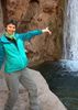
The bouldering demands became ever harder in the last 1.3 miles leading up to the big waterfall ledge... but fun and interesting. I did not linger at the falls, but scrambled up and around it on the south side, then enjoyed the next half mile of narrows before the basin opened up wide. When I'd first reviewed this drainage on a map, it appeared that I'd be able to follow it from this point another two or three miles then walk out on the south side, and over to FR 90A, to follow that back up the ridge to Mule Peak. For some reason, instead of following that original plan I exited the canyon bottom and moved immediately up and onto the ridge, heading for an old jeep route that was showing on the GPS unit. It was an easy climb out, and sure enough, the double track was right where is was supposed to be...

I followed that route until it started to loop around to the south side of Mule Peak, and instead of following that looping route, once again headed off cross country up a meadowed draw. Climbing out on top of that I was very surprised to discover an old Paved road! I turned towards the peak reflecting on why pavement (asphalt)... and soon discovered: an old and abandoned observatory installation. There were some run down living quarters, work rooms, and a large building with it's roof built on tracks such that the entire roof could slide off and back, opening up the upper levels of the building... which housed a contraption that looked to be straight out of "Alien". It had a seat towards the rear wherein someone would straddle a multi- tubed device, which I have to assume was some type of telescope.

Now, though the scientists are long gone, I think there are still active antennae installations up there.

So far, this peak hike had been diverse, entertaining... and really fairly easy.

Instead of heading back down canyon the way I came up, I now decided instead to track further down ridge and enter the drainage like I had originally planned, creating a lasso loop.

Very bad idea.

Initially, the side canyon was just too densely blocked to drop over the edge. Finally, I was able to descend, but it turned into a descent to hell. The drainage this far up was just a steep defile... a rocky ravine... and, filled with snow! There was no safe footing... so the progress was way too slow. I finally exited the ravine on the other side just for safeties sake, only to discover that ridge filled with dense oak scrub... and thorny things. The next few hours were all about thorny things, and amazingly slow progress. The slow progress is where the not getting to eat came into play. As I projected ahead, time wise, I realized that I could get caught in the canyon after sunset. Now, moving through that lower mile might not be so bad, but scrambling down and around that 100' water fall feature in the dark would not be fun... and, that 1.3 miles below the falls had numerous down climbing areas that I would have some trouble with in full daylight. After dark... no way. So, for those remaining afternoon hours I simply kept moving. The sun did set before I made it out, but I was in the lower canyon, below all the hard bouldering. There was enough glow to make my way down and out, and only the couple of miles of desert back to the truck were in the pitch black.

Now I know. A great hike up to the waterfall. A nice peak hike if the upper portion of the canyon is avoided. No real reason to go above the falls unless you are doing the peak (unless you brought along some rope and plan to make coming down the falls easy!) That upper canyon... sort of glad I did it, just to know, but I'll never go through there again... unless there is some compelling need to recreate the feel of visiting a hell dimension.

So... finally getting to eat my sandwich here after 11pm...
_____________________
Ageless Mind... Timeless Body... No Way! Use It and Lose It. Just the way it is...
 
average hiking speed 1.19 mph

WARNING! Hiking and outdoor related sports can be dangerous. Be responsible and prepare for the trip. Study the area you are entering and plan accordingly. Dress for the current and unexpected weather changes. Take plenty of water. Never go alone. Make an itinerary with your plan(s), route(s), destination(s) and expected return time. Give your itinerary to trusted family and/or friends.

helpcommentissue

end of page marker