username
X
password
register
for free!
help
ArticlesGuidesRoutes
 
Photosets
 
 Comments
triplogs   photosets   labels comments more
3 triplogs
login for filter options
Aug 24 2025
avatar

 Guides 12
 Routes 192
 Photos 863
 Triplogs 356

42 male
 Joined Nov 30 2015
 Phoenix, AZ
Upper Willow Lakes, CO 
Upper Willow Lakes, CO
 
Run/Jog avatar Aug 24 2025
ShatteredArmTriplogs 356
Run/Jog15.60 Miles 3,245 AEG
Run/Jog15.60 Miles   5 Hrs   26 Mns   42 Secs2.96 mph
3,245 ft AEG      10 Mns Break
 no routes
1st trip
Partners none no partners
Decided that instead of doing a summit it would be more pleasant to go to some alpine lakes, so I headed up to the Willowbrook TH with the goal of going to the Upper Willow Lakes, and possibly adding on a few extra miles at the end if I felt good. Saw a moose chomping on a tree about a quarter mile from the TH, and at the TH there was a sign warning that there could be moose in the area. So that added an extra bit of excitement.

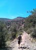
Started out on Ditch Trail, which climbs steeply the first mile (~600 feet). After that, it's pretty mellow as it parallels the North Fork of Willow Creek (although it's only near the creek where it hits Gore Trail). A couple miles of this stretch of trail is through a moderately burned area with lots of deadfall, but the trail has been well maintained, with no logs across the trail.

At around mile 3, where you leave Gore Trail and head SW on the North Willow trail, the grade steepens again, before finally leveling out at around 4 miles in. From here, I was actually able to do a decent amount of running, and the scenery gets way more interesting as the trail contours back towards the creek, with some nice views along the way.

There were maybe 4-5 alpine lakes along the last mile of trail, a couple groups of campers, and a few picturesque views. Got to the uppermost lake in about 2 hours (~6.5 miles). Definitely worth the trip.

On the way down, did a little more jogging, with a detour up to Salmon Lake. This lake was more notable for its size, but wasn't as picturesque as a couple of the others.

Jogged much of the way down, and felt good enough to stay on Gore Trail for a couple more miles until its junction with Mesa Cortina trail. Followed that for a short distance to the pleasant Willowbrook trail, which I took back to the trailhead.
_____________________
 
Jul 24 2023
avatar

 Routes 7
 Photos 273
 Triplogs 234

54 male
 Joined Jul 16 2011
 Phoenix, AZ
Mesa Cortina Trail #32Northwest, CO
Northwest, CO
Hiking avatar Jul 24 2023
EartheistTriplogs 234
Hiking0.62 Miles 90 AEG
Hiking0.62 Miles      19 Mns   1.96 mph
90 ft AEG
 no routesno photosets
1st trip
Linked   none no linked trail guides
Partners none no partners
Don't think this was the trailer we did, but closest I could find on the map. Hiked with my daughter so needed something easy
_____________________
 
Jul 01 2010
avatar

 Routes 37
 Photos 2,160
 Triplogs 627

43 female
 Joined Mar 01 2010
 Phoenix, AZ
Mesa Cortina Trail #32Northwest, CO
Northwest, CO
Hiking avatar Jul 01 2010
juliachaosTriplogs 627
Hiking5.50 Miles 1,000 AEG
Hiking5.50 Miles   2 Hrs   20 Mns   2.36 mph
1,000 ft AEG
 
1st trip
Linked   none no linked trail guides
Partners none no partners
Took this beauty of a trail this afternoon with my dad. This is actually a gateway trail to some other nice sights in the wilderness, but today we only had time for the official Mesa Cortina segment.

This trail took us through tall aspen forests and expansive meadows of wildflowers. The trail's mostly in good shape except for the areas where the water runs through. However, log bridges have either been placed or built along the way to aid in crossing the streams. This seems to be a popular trail for horses also, but bikes are not allowed. Not too many people out today, but I gathered from interactions with other hikers that it can get pretty busy.

The trail goes for about 2.7 miles and then meets up with the Gore Range Trail. Taking this to the right will take you up to Willow and Salmon Lakes. Continuing straight will take you to the more popular Willow Falls. There are several options for looping your route back here, including adding Buffalo Mountain to the mix (a more difficult hike for sure!), but we unfortunately had no extra time to explore. Very beautiful area, and definitely worth a visit if you're ever in the area.
 Culture
 Culture [ checklist ]
[ checklist ]  HAZ Rides
 Named place
 Named place [ checklist ]
[ checklist ]  South Willow Creek
wildflower observationwildflower observationwildflower observationwildflower observationwildflower observation
Wildflowers Observation Moderate
_____________________
 
average hiking speed 2.42 mph

WARNING! Hiking and outdoor related sports can be dangerous. Be responsible and prepare for the trip. Study the area you are entering and plan accordingly. Dress for the current and unexpected weather changes. Take plenty of water. Never go alone. Make an itinerary with your plan(s), route(s), destination(s) and expected return time. Give your itinerary to trusted family and/or friends.

helpcommentissue

end of page marker