username
X
password
register
for free!
help
ArticlesGuidesRoutes
 
Photosets
 
 Comments
triplogs   photosets   labels comments more
Pyramid Peak 2269 - 3 members in 8 triplogs have rated this an average 3.7 ( 1 to 5 best )
8 triplogs
login for filter options
Nov 22 2020
avatar

 Routes 215
 Photos 1,337
 Triplogs 124

53 male
 Joined May 26 2017
 Phoenix, AZ
Pyramid Peak 2269Phoenix, AZ
Phoenix, AZ
Hiking avatar Nov 22 2020
Nate_FTriplogs 124
Hiking6.33 Miles 4,247 AEG
Hiking6.33 Miles   3 Hrs   54 Mns   1.87 mph
4,247 ft AEG      31 Mns Break
 
Linked   none no linked trail guides
Partners none no partners
Time for my periodical trip out to Deems and Pyramid. Always a fun day walking around!
Wanted to test out my new phone and its camera in different modes. Works good! Especially the sunrise shots.
I took the faint use trail up to the saddle of Pyramid, because I had never been there before, wanting to know if the South side was climbable. Got halfway up and found that it wasn't. ](*,)
So I went around and up my usual way. The summit register and flag are gone, I wonder what happened to them?
It's amazing how many people park by the canal and go into state land these days. And the no parking signs are all but ignored.
They even put a port a john past the road closed sign! :lol: Lots of bikers and motorcycles out today. Even a boulderer with his mat heading out. Pyramid is always interesting!
BTW: my AEG gets messed up on Route Scout lately. The other apps have it about 1,300 AEG. :?
_____________________
  1 archive
Dec 07 2019
avatar

 Guides 1
 Routes 226
 Photos 1,675
 Triplogs 1,867

65 male
 Joined Oct 17 2008
 Phoenix, AZ
Pyramid Peak 2269Phoenix, AZ
Phoenix, AZ
Hiking avatar Dec 07 2019
rcorfmanTriplogs 1,867
Hiking3.05 Miles 751 AEG
Hiking3.05 Miles   1 Hour   52 Mns   1.74 mph
751 ft AEG      7 Mns Break
 
no photosets
1st trip
Linked   none no linked trail guides
Partners none no partners
I decided to head to BFE and walk like an Egyptian up Pyramid Peak this morning. My time was limited, so instead of walking out my front door, I drove up to the CAP canal, and walked from there.

I crossed the canal over the 51st Ave bridge, jumped the barriers, and continued along 51st Ave for awhile before cutting across towards the north slopes of the peak. No matter how you slice it, it's a fairly steep climb and I had to use my hands in places. It's rotten granite, so the rock is rough and some may prefer to wear gloves. Me, I never seem to think to bring them.

My target today, was a geocache that was hid way back in March 2006, but got archived in 2014 and was relisted last November. I originally found it almost 12 years ago, my last time on this peak. The cache is a bit north of the summit, so after I found it, I continued to the top, contemplated continuing south, decided I had no desire to risk that, turned around and headed back down to the north.
_____________________
Go find a LonelyCache
  1 archive
Nov 30 2019
avatar

 Guides 4
 Routes 52
 Photos 1,303
 Triplogs 75

female
 Joined Feb 04 2017
 Sun City
Pyramid Peak 2269Phoenix, AZ
Phoenix, AZ
Hiking avatar Nov 30 2019
caragrueyTriplogs 75
Hiking4.80 Miles 820 AEG
Hiking4.80 Miles
820 ft AEG
 no routes
1st trip
Linked   none no linked trail guides
Partners none no partners
Rinse and repeat! Nice morning stretch. Its pretty sad all the garbage, broken glass, and heaps of people that im pretty sure are there without permits!
_____________________
 
Jan 27 2019
avatar

 Routes 215
 Photos 1,337
 Triplogs 124

53 male
 Joined May 26 2017
 Phoenix, AZ
Pyramid Peak 2269Phoenix, AZ
Phoenix, AZ
Hiking avatar Jan 27 2019
Nate_FTriplogs 124
Hiking5.15 Miles 875 AEG
Hiking5.15 Miles   4 Hrs   10 Mns   1.42 mph
875 ft AEG      33 Mns Break
 
Linked   none no linked trail guides
Partners partners
caragruey
Needed to climb this peak after years of staring at it out the window going down I-17. It was calling me.
I brought HAZ'er Cara, grabbed a permit, and we made our way out.
Parking at Deems Park is a good place to start, although some cars were parked at the dead-end of Stetson/51st Ave right by the canal. I wasn't sure that was allowed, but then again, what do I know? We did see some people hiking and biking near Pyramid. My partner asked if people had a permit to be out here. :o Funny. :lol: Not many people otherwise.
The terrain is similar to Scarlett Canyon just East of here, rocky like Camelback, just not crowded.
No trail to speak of, except the track on my phone. A bushwhack/climb the whole way up. A couple of false peaks and good/solid holds the whole way. Mind you, it took some time, but we made it to the top. The views were great all-around. There was a small metal box with a band-aid and pencil, but no paper to write on; no summit register. Surprised me there was an American flag standing tall and proud with some solar lights attached. Took the obvious selfie and made our descent very slowly. I'm glad I finally nailed this obscure peak! :y:


 Culture
 Culture [ checklist ]
[ checklist ]  Old Glory
_____________________
  2 archives
Sep 17 2016
avatar

 Guides 3
 Routes 202
 Photos 3,513
 Triplogs 530

male
 Joined Jan 24 2016
 Arizona
Pyramid Peak 2269Phoenix, AZ
Phoenix, AZ
Hiking avatar Sep 17 2016
MountainMattTriplogs 530
Hiking2.76 Miles 729 AEG
Hiking2.76 Miles   1 Hour   30 Mns   2.44 mph
729 ft AEG      22 Mns Break15 LBS Pack
 
1st trip
Linked   none no linked trail guides
Partners none no partners
I've had Pyramid Peak on my list ever since I caught a glimpse of that little stunner right off the 303 (Sonoran Desert Highway).
Lately ive been making the most out of my recently bought SLT permit and I couldn't resist finally climbing this little gem!

There are some stunning car sized boulders that outcrop the base of PP that look similar to photos of J-Tree National Park minus the Joshua trees of course.
I remember reading Barrett's detailed description saying he has summited the mountain from nearly every direction but the northern approach was the easiest. I opted for the eastern approach since it was in my line of path when I met the base of Pyramid.
Steep is the only way up this bad boy but its not bad at all, rather quite enjoyable since the views only get better as you elevate. Although near the top of the summit the rock is more crumbly than a expired Nature Valley Granola Bar!
This is also the point where it's becomes fun and easy scrambling the remainder of the way up and as long as you take time choosing the correct hand and foot placements then the crumbling scree is no issue.
Summit conditions were as described in most recent triplogs unfortunately...
An abundance of trash, graffiti, a flag pole with tattered remainders of a flag, and a ammo box summit register filled with all sorts of junk! ](*,)
I cleaned up as much crap as I could and added another clean summit notepad.
Other than that the views up there were great and it was nice to finally knock this one off the list since I stare at it every time I head up north.
Second little desert off-trail peak for the day and the 4th one for the week, with progressively cooler weather I'm now certain I'll never be home now that I don't have to drive as far to enjoy a decent hike! : rambo :
_____________________
  7 archives
Jan 04 2016
avatar

 Guides 69
 Routes 37
 Photos 3,010
 Triplogs 2,387

55 male
 Joined Oct 24 2010
 Phoenix,Az
Pyramid Peak 2269Phoenix, AZ
Phoenix, AZ
Hiking avatar Jan 04 2016
mt98dewTriplogs 2,387
Hiking3.85 Miles 820 AEG
Hiking3.85 Miles
820 ft AEG
 no routesno photosets
1st trip
Linked   none no linked trail guides
Partners none no partners
Have eyed this mountain for several years and today I thought I would try to squeeze it in between sprinkles. Parked at the Deem Hills Park and took the streets to get to the canal crossing. There are a myriad of trails on the other side that could keep me gridding for months, but my focus was on the peak. The climb was definitely a scramble, using my hands on quite a few portions of my climb. The top was pretty much as described by Charger55, though the flag looked new. The register was more of a trash box with no real triplog to speak of. Went down te same way I went up....very carefully. I was very lucky in that it really didn't start to rain until I got down to flat ground. Cool little hike.
_____________________
 
Feb 06 2015
avatar

 Guides 4
 Photos 542
 Triplogs 573

46 male
 Joined Oct 19 2010
 Mesa, AZ
Pyramid Peak 2269Phoenix, AZ
Phoenix, AZ
Hiking avatar Feb 06 2015
Charger55Triplogs 573
Hiking3.60 Miles 820 AEG
Hiking3.60 Miles   2 Hrs   30 Mns   1.44 mph
820 ft AEG
 no routesno photosets
1st trip
Linked   none no linked trail guides
Partners none no partners
After hiking the Deem Hills Circumference Trail I went looking for something else to do nearby. This peak gave me a chance to put my State Trust Land permit to use. The hike description says to park at Deem Hills Park, but you can shave off some distance and park closer to the STL boundary if desired.

The desert floor leading to the mountain is unsightly. Broken glass, shotgun shells and discarded electronics are everywhere. The peak, being a difficult off-trail climb, was at least going to be in pristine condition, right? Nope, there was graffiti on the summit; large, purple letters spraypainted on the rocks. There was also a tattered American flag, an ammo box full of junk and the summit notepad laying out in the open. One flip through revealed such words of wisdom as "F--- Everything" and "Smoke Weed All Day Everyday". On the descent I noticed a shirtless man milling about one of the rock outcroppings down below. A fellow hiker? Maybe. It was warm enough to be topless. But I steered clear just in case.
_____________________
"I've driven across deserts, driven by the irony, that only being shackled to the road could ever I be free"
- Frank Turner "The Road"
 
Jan 15 2009
avatar

 Guides 27
 Routes 61
 Photos 2,620
 Triplogs 700

69 male
 Joined Jan 23 2008
 Phoenix, AZ
Pyramid Peak 2269Phoenix, AZ
Phoenix, AZ
Hiking avatar Jan 15 2009
AZWanderingBearTriplogs 700
Hiking2.00 Miles 820 AEG
Hiking2.00 Miles
820 ft AEG
 no routesno photosets
1st trip
Linked   none no linked trail guides
Partners none no partners
Very late log since I wasn't really into HAZ at the time and I don't think this description existed back then. The two geocaches referenced are long gone since Arizona doesn't allow geocaches on State Trust Land (our land) because of extreme pressure from the EPA. But from the top of Pyramid on a clear day you can just make out downtown where the bureaucrats cluster. So face South and give them the appropriate salute.

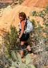
Decided to tackle Pyramid Peak (and snag Khufu and Ramses geocaches) on this gorgeous Arizona winter day. Drove in from Carefree Highway and parked about .27 miles from Khufu. Attacked Khufu first by ascending along the NNE ridge line. Initial going was steep but easy enough. About 600’ from Khufu it turned into hand over hand rock climbing. But 40 minutes into the climb I had the cache in hand.

Worked up to the Pyramid summit and enjoyed the view for a while. Didn’t see a summit log. Guess I should have brought one along. Peeked over the southern face of Pyramid at Ramses taunting me from just 300+ feet below. Feeling half my 52 years (or perhaps just light headed), I decided to go at him directly down the southern summit face. The seat of my hiking trousers will need repair from my reverse crab technique and the frequent slides on my posterior. But success was mine when I signed the log for Ramses.

I opted to descend west from the saddle and walk around the mountain back to my vehicle. Fairly easy descent.

If you tackle this hill just remember the following; it’s steep and most of the rocks are loose, so be extremely aware of your footing and grips. Having said all that, it is a great climb.

Finally, on a personal note, I had a very sad experience after completing this adventure. My constant companions for the last few years have been the most comfortable hiking boots I’ve ever owned. Lately, as much as I have tried not to notice, they have been showing their age. Not to say they don’t have much tread, but I can step on a penny and tell if it is heads or tails. The Goretex label just said "G" on the left and the right had gone by "tex" for a few years now. I’ve dreaded the day, but when I got home and took them off by the back door just one look told me they didn’t have another summit left in them. Not that I doubt they’d try, but at some point the cracked and torn uppers, the baby butt smooth soles, the frayed laces just can’t handle it any more. It was definitely an Old Yeller/Marley and Me moment when I took them over to the trash can. I knelt and gently tied their laces together for the last time lest they get separated in the hereafter. I placed a favorite old pair of worn out holey socks with them on a cardboard bed I made in the trash can. Tomorrow they will go to the land fill we drove past enroute to wonderful adventures so many times. Sure, I’ll go buy some new puppies for the feet. They’ll be full of the latest technology, have cool names, and weigh next to nothing. Yet for all the promises they make, some blisters are still inevitable. I know I will come to love them one day, too. But I’ll always miss the old Merrells. Good bye old friends! We sure had fun.
_____________________
All you have is your fire...
And the place you need to reach
 
average hiking speed 1.78 mph

WARNING! Hiking and outdoor related sports can be dangerous. Be responsible and prepare for the trip. Study the area you are entering and plan accordingly. Dress for the current and unexpected weather changes. Take plenty of water. Never go alone. Make an itinerary with your plan(s), route(s), destination(s) and expected return time. Give your itinerary to trusted family and/or friends.

helpcommentissue

end of page marker