|
| | | |
| |
|
| Hiking | 5.59 Miles |
1,942 AEG |
| | Hiking | 5.59 Miles | 3 Hrs 49 Mns | | 2.52 mph |
| 1,942 ft AEG | 1 Hour 36 Mns Break | 15 LBS Pack | | |
|
|
| |
| Linked |
|
none
[ show ]
| no linked trail guides |
| Partners |
|
none
[ show ]
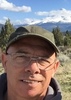
| no partners | | Black Butte is a dacite dome volcano that is just north of the city of Mount Shasta, sitting alongside Interstate 5. Having been born in Mount Shasta, having lived in Weed for the first five years of my life, and spending many summers and other times of the year over my life with various relatives still in the area (my parents moved back to area 10 years ago), I have always wanted to climb Black Butte. Frankly, I don't know what took me so long.
The trailhead is on the east side of the mountain. Driving north out Mount Shasta up the Everett Memorial you come to sign directing you west to the Black Butte trailhead. It's a 3.3 mile drive on a decently maintained Forest Service road to the trailhead. I got there about 7:15 am. No one else there. It was 44 degrees outside, with a 10 mph gusts of wind. All in all, not a bad morning to make the hike. The first quarter mile of the hike is in trees, but when you pop out, and look up at the side of the mountain, it's imposing. The slope is chunks of broken dacite, at a 45 degree angle. Basically you loop around the mountain counterclockwise from east to west side of the mountain, then the trail turns and goes back east until you come to a few little switchbacks near the top. A lot of the trail is scree, but you can move fast. Once you get near the top, it flattens out somewhat. The last 50 feet or so to the summit, where the foundation of the old fire lookout is, is a scramble. It was a bit windy on top, but still breathtaking. Mount Shasta looms to east and Mount Eddy to the west. It was cloudy and cold on top, so I didn't linger too long. I couldn't find a summit register, and I didn't bring anything up to use as one.
I made the trip up in 2 hours, and back done in 1 1/2. I met a lone hiker on the way down, but that was it for human contact. |
| _____________________
| | |
|
|
|
 Route Editor