|
| | | North Lake Campground, CA | | | |
|
|
North Lake Campground, CA
| | |
| |
|
| Car Camping | 3.19 Miles |
1,003 AEG |
| | Car Camping | 3.19 Miles | 1 Hour 23 Mns | | 2.39 mph |
| 1,003 ft AEG | | | | |
|
|
| |
| Partners |
|
[ show ]
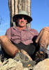
| partners | | this was our third trip to the eastern sierras
left early friday morning, arriving in bishop mid afternoon
drove up highway 168, checking out several campgrounds along the way
ended up at north lake campground, getting one of the last spots
a little higher and cooler, but our first big hike would begin 20 yards from our campsite - pretty convenient
john and denny agreed to a short acclimation/exploration/shakedown hike
we went up paiute pass trail about a mile and a half and turned around
didn't realized we gained 1000 feet in that short distance
nice to be moving after a long ride in the flying focus 
this was the coldest night, and with sunset just after 7:00, we were all in our sleeping bags pretty early
we'd been discussing this trip for several months, and had three good dayhikes planned
picked hikes from denny's book from the three trailheads nearby: north lake, lake sabrina, and south lake
a great weekend camping and hiking with the boys in this beautiful area  |
| _____________________
| | |
|
|
|
 Route Editor