username
X
password
register
for free!
help
ArticlesGuidesRoutes
 
Photosets
 
 Comments
triplogs   photosets   labels comments more
3 triplogs
login for filter options
Oct 24 2016
avatar

 Guides 3
 Routes 202
 Photos 3,513
 Triplogs 530

male
 Joined Jan 24 2016
 Arizona
Orion Peak - Wickenburg MountainsPhoenix, AZ
Phoenix, AZ
Hiking avatar Oct 24 2016
MountainMattTriplogs 530
Hiking1.72 Miles 503 AEG
Hiking1.72 Miles   2 Hrs   4 Mns   1.23 mph
503 ft AEG      40 Mns Break15 LBS Pack
 
Linked   none no linked trail guides
Partners none no partners
Woke up early for sunrise and finally brought my camera along with me to the summit of one of the random desert peaks I've hiked before and I'm happy I did.
Wispy clouds not only provided some great lighting but also kept the morning weather cool and enjoyable.

It was my second time on this nice little rock formation so I explored a bit more and found not only a natural arch but a nearby cave that actually had an opening large enough to crawl through it and get on top of the cave itself.
Needless to say I kind of like this random little mountain that boasts great views, a quiet surrounding desert and a large water tank/pond that sits near it's slopes which all make for quite a nice little place.

*SLT Permit Required
 Named place
 Named place [ checklist ]
[ checklist ]  Orion 2625  Orion Tank
wildflower observationwildflower observationwildflower observationwildflower observationwildflower observation
Wildflowers Observation Light
Wildflowers in October, Oh the incredible diversity of Arizona!

water 1 out of 5water 2 out of 5water 3 out of 5water 4 out of 5 Orion Tank 76-100% full 76-100% full
_____________________
  4 archives
Sep 18 2016
avatar

 Guides 3
 Routes 202
 Photos 3,513
 Triplogs 530

male
 Joined Jan 24 2016
 Arizona
Orion Peak - Wickenburg MountainsPhoenix, AZ
Phoenix, AZ
Hiking avatar Sep 18 2016
MountainMattTriplogs 530
Hiking1.88 Miles 471 AEG
Hiking1.88 Miles   1 Hour   6 Mns   2.82 mph
471 ft AEG      26 Mns Break15 LBS Pack
 
Linked   none no linked trail guides
Partners none no partners
Really filling the void of not going on a big trip this weekend and set out for yet another quick and eay off-trail random desert peak bag.

Originally headed to Hiero 2682 which resides next to English Wells which is just north of Highway 74 & 211th ave but I ran into private property about a mile from its base. I had stopped by the area before and the signs along the highway stated SLT area so I figured I was fine but while there I did a quick online view of the land ownership parcel map and I realized the small portion that Hiero 2682 lies on is private property for some odd reason. No structures, property, ranch or anything of significance on sat view resides within the area so I'm curious to know why it's pp.
With the day coming to an end I quickly looked at my map and noticed another random little peak labeled Orion that I had interest in was only 9 miles away so I hopped back in my SUV and sped away, well dropped it back into 4Low that is and climbed up the many obstacles on the road back out, fun stuff! :DANCE:

Made it near the base of Orion just before 6pm with just enough time to make it to the top and back down with natural light. Out of all the random desert peaks I've hiked this past week this one is my favorite by far!
The mountains geoolgy consists of some kind of unique jagged reddish rock that has numerous caves and crevices all throughout it. There was also a surprising bonus along the eastern base of the mountain, it is a rather picturesque large water tank and a nice little basin area created by man but fed by the many large washes that flow into it.
From there I just aimed for the break in the saddle just below Orion's summit and quickly made my way up. The consistency of the terrain was a dream compared to yesterday's crumbly ascent on Pyarmid Peak.
About 100 yards out from the summit is when a fun and easy scramble begins, so easy in fact that I choose to have fun and do a little exposed class 3 climbing that was a more direct way to the top and as said before the rock was so solid and stable compared to other mountains I've been on lately so it made this even more enjoyable!

I may say adjectives like spectacular and beautiful a lot but the Orion summit views were downright righteous! 8)
I can understand why it was a triangulation station back in the day, clear uninterrupted views for miles and miles in every direction! I could have sat up there forever to soak it all in and as always utilize the elavation to scout out future trips around that area but I was losing light with every mintue. Pristine summit conditions showed signs of not many visitors and the summit register backed that up, last signed ascent was in 2011 and the register location is hard to miss.
Enjoyed this one so much I will definitely be back to play around and explore, I figure 3,975 in AEG and 17.45 miles of off-trail hiking in the past 6 days are the equivalent to one typical big trip so I guees I got my outdoor fix for the time being... : rambo :

***Orion's HP is 2625 ft in elavation and I'm not sure whether it belongs to the Wickenburg Mountains or Hieroglyphics, it's unclear when viewing the topo map.
 Named place
 Named place [ checklist ]
[ checklist ]  Orion Tank  White Tank Mountains

dry Iona Wash Dry Dry


water 1 out of 5water 2 out of 5water 3 out of 5water 4 out of 5 Orion Tank 76-100% full 76-100% full

dry Trilby Wash Dry Dry
_____________________
  5 archives
Nov 19 2014
avatar

 Guides 4
 Routes 51
 Photos 1,545
 Triplogs 348

86 male
 Joined Sep 24 2004
 Phoenix, AZ
Orion Peak - Wickenburg MountainsPhoenix, AZ
Phoenix, AZ
Hiking avatar Nov 19 2014
black_toesTriplogs 348
Hiking2.56 Miles 695 AEG
Hiking2.56 Miles   2 Hrs   48 Mns   1.57 mph
695 ft AEG   1 Hour   10 Mns Break
 no routes
1st trip
Linked   none no linked trail guides
Partners none no partners
My continued exploration of the Trilby Wash area in northwestern Maricopa County near Wittmann, Morristown and points N.

Orion, at 2,625' el, is the highest of an isolated out-croppng of small peaks several miles N of the junction of N. Castle Hot Springs Rd and 74 Highway near Morristown. Orion offers the best views of Trilby that I've come across: S to Circle City and beyond and N until it vanishes in high mountains below Red Picacho.

I parked along the Castle Hot Springs Rd and walked the dirt road E .7 of a mile to a barbwire gate. From there it is was a mystery how to proceed. I had done a recon of the area last spring and did not see a trail anywhere. I decided to head up to a saddle just W of Orion and try to find a good route to the summit.

It took 24 minutes of bushwhacking to cover less than a quartermile to reach the saddle. Lots of boulders and loose rock, not to mention brush, small trees and cactus. I examined the steep spine of Orion and thought it had too much rock and underbrush. Going around to the south side, I started up more or less on a contour route but finally sucked it up and followed a steep drainage to the W end of Orion. Scrambling over and around large boulders, I finally approached the summit from the WSW. It had taken 33 minutes of hard work to get there from the ridge.

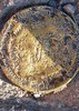
The rocky summit itself runs about 25 yards, SE and NW. I found the triangulation disk (1924) and two reference marks (1947). All said "Orion," which is also the name of a mine to the northwest. There is a strand of wire near the middle, for what purpose I don't know. No sign anyone had been up there for months, maybe years. The disks, I read, were last checked in 1969. Splendid views. Shot some photos and video and decided to head down a little before 4 o'clock. I knew one thing. I didn't want to descend the same way I came up. The spine on the W seemed the best option, even though I'd rejected it earlier.

Just down from the summit, I spotted what I thought was a geocache. I'd read there was one up here called "Crack in The Rock." I found a red-dyed male underwear and a traning bra. The items were torn and weathered and tied to a rock in a protected spot. I looked for a log book but didn't see one. Maybe the cache was somewhere else but really hidden.

The spine, though rocky and covered in places with low lying trees and brush, was clearly the route I should have gone up. It took 40 minutes to reach the gate, 14 minutes quicker than on the ascent from the S.

Great afternoon and a good little adventure in off-trail hiking.
_____________________
 
average hiking speed 1.87 mph

WARNING! Hiking and outdoor related sports can be dangerous. Be responsible and prepare for the trip. Study the area you are entering and plan accordingly. Dress for the current and unexpected weather changes. Take plenty of water. Never go alone. Make an itinerary with your plan(s), route(s), destination(s) and expected return time. Give your itinerary to trusted family and/or friends.

helpcommentissue

end of page marker