|
| | | White Creek to Mogollon Crest, NM | | | |
|
|
White Creek to Mogollon Crest, NM
| | |
| |
|
| Run/Jog | 14.61 Miles |
2,017 AEG |
| | Run/Jog | 14.61 Miles | 5 Hrs 20 Mns | | 2.74 mph |
| 2,017 ft AEG | | | | |
|
|
| |
| Partners |
|
none
[ show ]
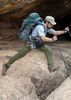
| no partners | | This was intended to be a day trip up to the Mogollon Baldy summit. I wasn't sure whether to take Mogollon Baldy trail or the slightly longer route through Rawmeat Creek and along the crest. Having seen the start of Mogollon Baldy trail the day before, and knowing that it goes through a big burn scar, I thought route finding might be problematic. So I opted for the longer route.
Started up Trail 155 at White Creek Cabin (this part of the trail is labeled as "Little Creek Trail" on the maps), and headed up to McKenna Park. By the time I got up there I was already feeling the lack of sleep and the fatigue from the previous day, so I had a lot of doubts whether I would actually make it to the summit. McKenna Park is mostly easy going.
Headed down into Rawmeat Creek, where there was nice, refreshing flow up to a little past the Trail 302 junction. This was a nice stretch of trail. Once past Trail 302, it got a lot trickier, with the trail entering into a mile-and-a-half-or-so long burn scar. Couldn't find the trail half the time, but knew based on the map where to exit.
Once on the ridge up to the crest, it became a little easier, though it was quite steep in a couple of places. The view from the top overlooking the Mogollon Creek drainage was fantastic. Visually seeing how far up the crest I would need to go, along with a lack of any sign of Trail 169, I decided that some swimming in West Fork would be nice, and headed back down. |
| _____________________
| | |
|
|
|
 Route Editor