|
| | | |
| |
|
| Hiking | 8.00 Miles |
|
| | Hiking | 8.00 Miles | 6 Hrs | | 1.33 mph |
| | | |
| |
| Linked |
|
none
[ show ]
| no linked trail guides |
| Partners |
|
none
[ show ]
| no partners | | Catching up a bit.
We went to Capitol Reef NP over Labor Day. The temps were still in the low 100's so we stuck to hikes with water. Day one we hiked Pleasant Creek. This can be done as a through hike with two cars, but its a long drive between start/stop points. We were camped near the trail head just outside the park, so we hiked in and out. I'm breaking from convention for left and right, it will be referenced looking upstream since that is how my explanation will go.
Hike the road in until you hit Pleasant Creek, it was dry at this time of year, but has water running through the wash in the spring months. Cross the wash and follow the road up the other side of the creek. You'll see signs marking the NP boundary. You'll hear water running, follow that up the opposite bank and find the Aqueduct. This time of year, the entire flow of the creek is diverted into the Aqueduct. Follow the aqueduct into the park and you will come to the point that the water is being diverted. Cross the creek (left) and hike along the bank upstream till you come to a cow fence with a gate. Close the gate after passing through.
For a side trip, you can climb the wall on creek right and follow the drainage up onto the bench. There are some good views and you can cross over to the next northern canyon and hike down. It drops back into Pleasant a couple hundred yards downstream from the fence. Its all off trail with lots of scrambling. This route should give you access to a number of other options as well.
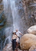
Once you cross through the gate you can choose to hike in the water or on either bank. You'll end up hopping in the water on and off throughout the hike so don't be afraid to get wet. The water was still chilly in the morning and made for a great way to wet down your clothes. You'll hike in another 1/4 mile or so and come to a hard left where the creek wanders left, then right. There is a shortcut up and over the bench. I prefer to stay in the water, but there are some petroglyphs on the wall, albeit partially vandalized. This hike is really beautiful and you get great views of the tall sandstone walls on this end. Hike along and be sure to keep looking up.
Another side trip - Somewhere about the 1-2 mile distance you'll come to a large, sandy, open area on creek left. There is a use trail toward the upstream end right by the sandstone wall. If you follow this in, you'll come to a wash. Follow that towards the right and it turns into a slot canyon. We followed it in until we hit a large muddy puddle and turned around. But it could go further and may actually meet back up with Pleasant Creek. This area is marked as a drainage on the trails illustrated map, right by the 5750 mark.
Back in the creek, you'll head into a narrower section of the canyon. Had quite a bit of shade on this trip. Another mile and we came to another bench on creek left. There was a herd of Big Horns in the area and we got some great pics. They did not seem too bothered by our presence. After this point the canyon starts to open up a bit. We kept hiking and enjoying the water. There are large benches with trails to hike on land if you desire. We got within about a half mile from the end and could see the Rangers quarters up on top of a hill in the distance and saw some tourist-looking 'hikers' up on the right ridge. I believe there are some ruins or petroglyphs to check out there. We decided this was the perfect time to turn around since we had not seen a single soul all day. The return trip was pleasant with lots of stops in the shade to fight off the growing heat. We followed the aqueduct past the start point on the way back, but its not really worth it. Just head back to the car and call it a day. In our opinion, the downstream end is the most scenic.
The forest road in from the Bullfrog-Notom Rd is rutted but I think you can get a passenger car in there with strategic straddling. Take it in and stay straight at the branches until you come to a downhill. This hill is rocky, you'll need to decide if you should park here or push on. We did everything in a Subaru. Once down the hill, turn left and find a spot to park before the road turns right and sharply downhill. |
| _____________________
| | |
|
|
|
 Route Editor