username
X
password
register
for free!
help
ArticlesGuidesRoutes
 
Photosets
 
 Comments
triplogs   photosets   labels comments more
Rainbow Bridge via South Trail - 13 members in 18 triplogs have rated this an average 4.8 ( 1 to 5 best )
18 triplogs
login for filter options
May 03 2024
avatar

 Guides 4
 Routes 491
 Photos 10,890
 Triplogs 1,257

55 male
 Joined Nov 20 2012
 Phoenix, AZ
Rainbow Bridge via South TrailNortheast, AZ
Northeast, AZ
Backpack avatar May 03 2024
BiFrostTriplogs 1,257
Backpack30.36 Miles 8,345 AEG
Backpack30.36 Miles3 Days         
8,345 ft AEG
 no routes
1st trip
Linked   none no linked trail guides
Partners partners
chumley
John9L
slowandsteady
9L was able to secure the permits for Rainbow Bridge South Trail. We all drove to the South Trailhead on Thursday night arriving quite late. With the late arrival we started hiking Friday morning just before 9am but shortly before starting 3 reservation dogs showed up and also decided they wanted to join us for the hike.

The trail traverses across the first five miles crossing some drainages the biggest being Horse Canyon. Otherwise it’s a series of short up’s and downs as we hiked towards Yabut Pass. Very scenic with the terrain being similar to Esplande layer in the Grand Canyon. Once at Yabut Pass we took a break and had a great view of the pending 2000 foot drop into Cliff Canyon.

Dropping into Cliff Canyon was tedious downhill and the trail was not as good as the first five miles. Eventually we made the canyon bottom and just after passing the 8 mile mark we hit the first water. Chumley had hiked ahead and found a nice bench camp site in the cool shade and with plenty of water in the creek.

We setup camp and just enjoyed the afternoon and of course the dogs enjoyed a power nap as well. Rest of the evening was pleasant looking forward to the day hike to Rainbow Bridge next day.

Next morning we headed out on the day hike. The first task was getting over Redbud Pass which was not as rough as we thought based on other triplogs. It was a really fun pass to negotiate and had some interesting geology and narrow sections. Once on the other side it opened back up into some nice meadows with wildflowers and higher canyon walls.

Eventually the trail intersected with Bridge Canyon which we followed passed the North Trail junction and Echo Camp. From Echo Camp it was only about ½ mile to Rainbow Bridge which is where we saw the first people of the trip. Fortunately, there was not a large tourist group only a couple of small groups. Most of us rested dogs included under a constructed shade cover at the bridge but Kathy hiked towards the lake and by chance she was offered some dog snacks by one of the boat people which was good because our food supplies did not count on 3 dogs.

After the break we headed back the same way. It was much warmer on the way back but we took some good breaks at some key water spots with a dip in one of the deeper pools. Back at camp settled in for another night.

However, overnight the winds really picked up to the point it was difficult to sleep. Next morning it was more of the same with high winds. We packed up and started the hike out. First, we had to climb the 2000 feet to Yabut Pass. This part was tough, and it got windier as we ascended to the pass. After the pass it was still windy but definitely better than the other side.

Eventually everyone made it back to the trailhead dogs included who acted like this is just what they do. Follow hikers into the wilderness and hang out for several days. It was a great trip and really enjoyed the maze of canyons closer to the lake. Thanks to 9L for getting the permits and setting up the trip!
_____________________
  2 archives
May 03 2024
avatar

 Guides 94
 Routes 842
 Photos 22,068
 Triplogs 1,994

52 male
 Joined Sep 18 2002
 Tempe, AZ
Rainbow Bridge via South TrailNortheast, AZ
Northeast, AZ
Backpack avatar May 03 2024
chumleyTriplogs 1,994
Backpack34.64 Miles 8,613 AEG
Backpack34.64 Miles3 Days         
8,613 ft AEG
 
1st trip
Linked   none no linked trail guides
Partners partners
BiFrost
John9L
slowandsteady
After a late arrival at the trailhead on Thursday night we set in for a good night sleep. Friday morning as we were organizing our packs a trio of local ranch dogs approached camp with cautious curiosity. Once they realized we were no threat to them, they apparently decided they wanted to adopt new humans, and spent the next three days following us through borderland canyons.

The first 5+ miles of this hike make a series of "small" canyon crossings as it traverses the southwestern slopes of Navajo Mountain. The views across this landscape are second-to-none. For a route that doesn't see that much use, it is in phenomenal condition -- as good as any secondary national park trail might be. The tread was clear, erosion mitigation was current and effective, and cairns were plentiful -- and enormous. Based on brush trimmings found over the next couple of days, I guess that work was done on the route last fall.

One important note about the route as explained in the description: at the top of the descent into Horse Canyon, the route to the right has been decommissioned. Previously posted GPS routes now follow a path that has very intentionally been obscured and intended not to be hiked anymore. This split is shown on many maps, including USGS Topo maps. But now, only the southern/western route traversing lower on the slope is still used.

If you are not following an older GPS track, you'd never know of this change. We didn't realize we were "off-track" until halfway to the bottom of the canyon because the trail is so well developed and marked that it would be almost impossible to go the "old way". Only on the return trip Sunday was I able to carefully look for the old route junctions and while desert landscape like this isn't quick to return to nature, somebody did a very good -- and deliberate -- job at leading hikers on the new (original?) route.

Back to the hike, the final push up to Yabut Pass dragged on but the views were stunning. A long traverse brings you to the first top of the pass which then meanders through some rough trail past the old campsite and down to the lower notch in the cliff that the trail passes through where the old sign marks the pass.

From here the 2000 foot descent was not as challenging as expected, with better trail conditions than previously reported. But that kind of elevation is knee-jarring even if the trail isn't awful. Reaching the bottom, I pushed ahead in search of that increasingly-sought-after first water and more importantly, the ideal site for our group to set up camp.

I ended up heading downstream almost a mile past where we ended up camping while searching for a better, and bigger, site for our tents -- and more importantly, shade from the blistering afternoon sun. Thankfully, the deep canyon walls provide shade where the lack of trees do not and we settled in on a shelf along a wall that featured welcome relief. We set up camp and all took a well-earned rest, led by the dogs, who might have made this same trip dozens of times, or perhaps didn't realize exactly what they were getting into when they decided to join our pack.

I took an hour or so before dinner to climb up above the canyon and get a better view of our surroundings, which was pretty amazing.

Saturday morning we headed out on our day trip to Rainbow Arch. The climb up Redbud Pass was not as challenging as reported and the descent never featured anything that resembled a climb or could possibly require a rope. I'm not sure if time has created a rockfall to alleviate the previous obstacles or if trail construction has occurred. It is now just a minor scramble in places. The meadows in Redbud Canyon below the pass are beautiful and were dotted with spring wildflowers.

Shortly after passing the junction with Bridge Canyon, and the junction with the north trail, we took a short break at a huge grassy camping area. While we had seen no footprints on the trail up to this point, there appeared to have been at least three people to have come in on the north trail in recent times, perhaps a week earlier. But not much traffic out here all things considered.

As the trail drops down to the Kayenta formation (which seems similar to the Supai in south rim drainages), water surfaces and the trail stays higher on the shelf above. As we traversed around toward Echo Camp, a view downcanyon provided the first view of the massive arch that was our destination. Before heading for the up-close view, we took the detour to see the popular camp. Spoiler alert: it echoes! A handful of separate camp areas each featured old bedframes and fire rings. A large marshy pond sits at the top of the canyon, along with a healthy patch of poison ivy. The top of the alcove includes yet another camp spot along with one of the three spots where we saw ample inscriptions from previous visitors.

Back downhill we headed over to the arch and all the requisite photos and observations. Kathy headed for the lake and was able to commandeer some much-appreciated kibble for our canine family from touristy boat people while the rest of us napped under the totally fake "natural-looking" shade structure.

The first part of the return was hotter than preferred but the turn into the canyon to head over redbud offered welcome shade and later we took the opportunity for a swim at a fantastic little pool we passed along the way. Back at camp the dogs stepped up defending our lives with some pointed aggression toward canyon ravens, which is tough not to appreciate.

On Sunday the wind forecast was notable but it picked up on Saturday night, and occasional gusts had everybody awake a few times. On the hike out, the two miles climbing up to Yabut Pass was unlike anything I have ever hiked in. Type-3 fun would be a stretch. Navajo Mtn was showing 60-70mph on the high wind warning forecast maps and there were gusts along the climb that were literally breathtaking. Several times I had to stop and crouch to maintain my balance. Think positive ... it wasn't sunny and hot like the day before!

The suck factor was marginally better after the pass, something I didn't expect, but also still miserable enough that I was ready to be done. The two younger dogs were on the same page as me and the three of us powered through the seemingly endless canyon crossings on the return to the trailhead without more than a brief stop to make sure I got them watered in the middle of 8 dry miles.

Back at the trailhead the pups got some treats from the cooler and we relaxed a bit waiting for the others to arrive. Once everybody was back we cleaned up quickly and headed our separate ways. The dogs ran behind the truck for a couple of miles but bailed in the area of some nearby ranches. They're probably still sleeping after a fun weekend in the wilderness. Just like the rest of us!

Final thoughts: There are cell towers on Navajo Mountain, so even in the deep canyons below, cell service was available much of the time. Comforting perhaps, but mostly annoying. Just put it in airplane mode and enjoy the remoteness of the place without a connection to the outside world. The trail seems to be in much better condition now than it has been for previous hikes. Is this a regular thing? Will it deteriorate quickly? And who is maintaining this trail anyway? Navajo Parks and Rec? NPS?

Thanks to 9L for planning and doing the legwork. Good to see the jeep on a fun road again. It was fun to hike with Karl, Kathy, and Kristy again, and a pleasure to meet and hike with Pops, Nipps, and Junior.
_____________________
I'm not sure what my spirit animal is, but I'm confident it has rabies.
 
May 01 2023
avatar

 Triplogs 2

male
 Joined Feb 11 2017
 Flagstaff, AZ
Rainbow Bridge via South TrailNortheast, AZ
Northeast, AZ
 Backpack avatar May 01 2023
LuckyPierreTriplogs 2
 Backpack13.18 Miles 2,561 AEG
 Backpack13.18 Miles
2,561 ft AEG40 LBS Pack
 no routesno photosets
1st trip
Linked   none no linked trail guides
Partners none no partners
Three of us hiked the South Rainbow Bridge trail at the end of April, 2023. We’re all near 70. A few things to keep in mind if you’re an older hiker or you’ve done this 40 years ago and are considering it again:

~Two of us did this backpack 40 years ago and remembered almost nothing about how to get to the trailhead and about the trail itself.
~Each of us carried 3.5 liters of water starting from the wash just past Haystack (1.5 miles to the trailhead), and returning to the trailhead from First Water. We needed more—probably 4.5 liters each, hiking during noon temperatures of 60 at the trailhead and 70 at First Water. On the return trip two of us ran out of water at Horse Canyon. Luckily it had rained the previous evening so there was water in potholes we could filter. Had it not rained, it would’ve been an extremely parched and painful slog back to the trailhead.
~On the majority of the trail we averaged around 0.5 to 0.8 miles per hour. Steepness, stair stepping 12” to 24” high boulders, bushwhacking through drainages, constantly watching our footing due to ankle-twisting softball-sized scree, and much marveling at the scenery cut into our schedule big time.
~We made it as far as Cliff Canyon (about 9 miles) before before realizing we didn’t allow enough time to reach the Bridge and meet our ride back at the trailhead. We’re in decent shape for being 70ish and think four nights and five days will enable most our age to complete the round trip with a tolerable level of pain.
~We started hiking at noon the first day and six hours later camped at a spot about a mile shy of High Camp. If we do this again, we’ll definitely go the extra mile to High Camp which had firewood and flat spaces for several tents. There is no flat ground for tents at Yabut Pass.
~Other descriptions were helpful locating the trailhead and while on the trail—no updates there except we didn’t think our RAV4 could cross the wash immediately after Haystack Rock so we hiked the 1.5 miles from the wash to the remnants of Rainbow Lodge/trailhead. A high-clearance vehicle is a must to cross the wash after Haystack and drive to the trailhead. Also, thick shrub growth prevented access to the outhouse in Cliff Canyon.
wildflower observationwildflower observationwildflower observationwildflower observationwildflower observation
Wildflowers Observation Light
Lots of budding penstemons and the redbud trees in Cliff Canyon we’re gorgeous.
_____________________
 
Dec 22 2019
avatar

 Routes 2
 Photos 1
 Triplogs 1

male
 Joined Jan 22 2013
 
Rainbow Bridge via South TrailNortheast, AZ
Northeast, AZ
Hiking avatar Dec 22 2019
polychromaticTriplogs 1
Hiking26.36 Miles 5,588 AEG
Hiking26.36 Miles2 Days         
5,588 ft AEG
 
1st trip
Linked   none no linked trail guides
Partners none no partners
The HikeArizona guide is very accurate. The following addenda may be of help. I hiked this route in late December 2019.

-Stats: About 13.4 miles to Echo Camp with 5,600' loss and 3,200' gain, this from fairly accurate and lightly edited GPS data. The descent from Yabbut Pass to the gut of Cliff Canyon was 1.7 miles and 1,560' of descent.

-Google Maps shows the correct location for "Rainbow Bridge South Trail Trailhead" (i.e. Rainbow Lodge), but the road that takes you there has a washed-out & closed section. Neither internet resources nor the Navajo Nation handout that came with my permit indicated this. You must now keep left at the Haystack Rock junction and then take your next right to join the road leading to the Lodge -- see HAZ directions and map photo.

-The whole route is strenuous; there is never an easy section until you get close to the Bridge. In the first 5.3 miles to Yabbut Pass, you'll gain and lose about 1,600' (Yabbut elevation only slightly higher than the trailhead). After the big drop into Cliff Canyon, the rest requires clamoring in and out of the wash, routefinding, and swatting brush, punctuated only by Redbud Pass. The whole thing is pretty grueling, even heading downcanyon.

-I was there about 7-10 days after a good dose of snow, after which followed generally fair winter weather. The sun-exposed areas before Yabbut Pass were a mix of dry and patchy, but the north-facing canyon descents had up to 4" of continuous snow, with Horse Canyon holding the most. There was also an icy slickrock stretch at (37.01559 -110.92330) with a bad runout that required a climb-around. Consider foot traction in snowy conditions. Fortunately, there was no snow down low in Cliff or Bridge canyons. Water was available in all the normal places this time of year.

-I mislocated Yabbut Pass when preparing my GPS data before the hike. I thought it would be at the high point at (37.02473 -110.92204) -- this is where you actually cross into the Cliff Canyon drainage, and there are several large cairns here that seem to mark it as a special spot. But from here you must descend and climb another short ways to the true Yabbut Pass at (37.02698 -110.92484). The first location is the better place to cache water or gear; Yabbut Pass is rocky and small.

-I found Redbud Pass to be easier than described. It's Class 2 scrambling through big, solid boulders for about 150 feet with very little exposure. I could see an inexperienced or balance-unsure hiker needing a partner assist or pack-passdown, but I think the vast majority of those attempting this hike will be just fine.

-When you get to Rainbow Bridge, there is an established trail leading around its eastern buttress that continues out towards the docks. NPS signs ask you to stay on trail. (The route description on HikeArizona hints at "finding your own way around"; stay on the trail!).

-This NPS video says there's a dinosaur footprint by the bridge! I didn't know before I went so I didn't look. [ youtube video ]

-There was refreshingly little garbage on the route, except in some fire pits. I packed a little out, please join me in cleaning the place up bit by bit!

-For footwear, I was glad I took over-the-ankle hiking boots. There's almost no slickrock walking or getting your feet wet, so approach/canyon footwear doesn't buy you much. But there is lots of loose, sandy, and rocky footing, so you want something sturdy.

-I noted the locations of 6 metal mile-markers and 5 suitable camps other than Echo. These are in my uploaded GPS data.
_____________________
  8 archives
Mar 23 2012
avatar

 Photos 106
 Triplogs 88

53 female
 Joined Sep 06 2010
 Tucson, AZ
Rainbow Bridge via South TrailNortheast, AZ
Northeast, AZ
Backpack avatar Mar 23 2012
IHikeTriplogs 88
Backpack13.18 Miles 2,794 AEG
Backpack13.18 Miles3 Days         
2,794 ft AEG
 no routesno photosets
1st trip
Linked   none no linked trail guides
Partners none no partners
Did this backpack with a local backpacking club... what a great trip! Sandstone country never disappoints and only leaves me craving more. Hiked in via the south trail, spent 2 and a half days exploring this beautiful country and lounging stream side. Rainbow Bridge was absolutely stunning... as always, mother nature never ceases to amaze me.
_____________________
 
Oct 23 2011
avatar

 Guides 13
 Routes 38
 Photos 1,651
 Triplogs 577

60 male
 Joined Nov 15 2005
 Jackson, CA
Rainbow Bridge via South TrailNortheast, AZ
Northeast, AZ
Hiking avatar Oct 23 2011
toddakTriplogs 577
Hiking28.00 Miles 3,700 AEG
Hiking28.00 Miles   12 Hrs   30 Mns   2.24 mph
3,700 ft AEG
 no routes
1st trip
Linked   none no linked trail guides
Partners none no partners
Very cool route through some great scenery to an amazing destination.
_____________________
 
Apr 18 2011
avatar

 Guides 107
 Routes 249
 Photos 2,067
 Triplogs 514

male
 Joined Nov 18 2005
 Phoenix, AZ
Rainbow Bridge via South TrailNortheast, AZ
Northeast, AZ
Backpack avatar Apr 18 2011
nonotTriplogs 514
Backpack28.00 Miles 5,600 AEG
Backpack28.00 Miles3 Days   16 Hrs      
5,600 ft AEG38 LBS Pack
 
no photosets
1st trip
Linked   none no linked trail guides
Partners none no partners
28 miles spread over 3 days (half, full, half) in a pair of shoes that combined to total about 1.5 soles :lol:

Pretty nice, not spectacular, though. Nice easy trip, broke in a few first timers :y: to backpacking. Good weather.

Water flowing lightly in Cliff Canyon the last half mile to Redbud. Water in nearly all parts of Bridge Canyon Creek and Redbud Creek.

AEG is high for the hike description, for one way from the south TH it is overstated. From the total, subtract 2000 for the climb out and divide by two, it's about 1800 ft AEG for the one way, which is still a bit considering you think it's downhill.
wildflower observationwildflower observationwildflower observationwildflower observationwildflower observation
Wildflowers Observation Light
_____________________
http://hikearizona.com/garmin_maps.php

Hike Arizona it is full of sharp, pointy, ankle-twisting, HAZmaster crushing ROCKS!!
Hike Arizona it is full of sharp, pointy, shin-stabbing, skin-shredding plants!
Hike Arizona it is full of striking, biting, stabbing, venomous wildlife!
 
Apr 02 2011
avatar

 Guides 6
 Routes 6
 Photos 1,634
 Triplogs 186

58 male
 Joined Apr 04 2002
 Flagstaff, AZ
Rainbow Bridge via South TrailNortheast, AZ
Northeast, AZ
Backpack avatar Apr 02 2011
squatpukeTriplogs 186
Backpack13.18 Miles 2,794 AEG
Backpack13.18 Miles3 Days         
2,794 ft AEG50 LBS Pack
 no routes
1st trip
Linked   none no linked trail guides
Partners partners
PaleoRob
Randal_Schulhauser
ToadOfTheRocks
Another great trip with PageRob; good bro is a serious hiker and always a blast to partner up with...if you haven't been on a PageRob expedition, I highly recommend.

Randy picked me up at Flagstaff and we rendezvoused with the crew at Fiesta Mexicana in Page that same night, at 5pm. We were able to meet Rob's and Toad's wives which proved interesting since they became participants in our adventure as well.

After dinner, Randy went back to Safeway to replace the stout that uncapped in his truck on the way up... :( I picked up a gallon of aqua for my camelback and few apples to compliment the hotel's instant oatmeal breakfast. After our morning's regularities, Randy and I drove over to the Gay residence for final preparation.

The drive to the TH was long and I appreciated Randy offering me the front seat since 3 in the back of Rob's midsize would have been cozy. We stopped for a few photo ops; the weather at this point was phenomenal. A wrong turn near the trailhead cost about hour and some wear/tear on Rob's truck as well as our stress levels. Our minds eased, when we found the Rainbow Lodge and its distinct cabin site remains. With endorphins high, we started our trek.

The majority of the trail was well marked yet very rocky. We survived several miles of valley's and ascents only to arrive at the STEEP Yabut pass....HOLY CATS....I looked down at the unshaded 2 mile, knee shattering descent and knew this would be rough. So I buckled in, grabbed a swig from the camelback and hit it hard...finally arriving at the bottom dry creek to removed my pack. I waited for what seemed like 30+ minutes...then finally got anxious that someone had gotten hurt. W/O pack, I hiked back up a few switchbacks to see if I could find the crew. I saw all, moving forward about 3/4 the way down; relieved, I hustled back down to my pack and waited another 15+. The delay came from a pow-wow the other 4 had without me, appears 2 members were having knee issues and the group concluded we would NOT be hiking back out.

Toad, Rob and I pushed on from the descent bottom and after a mile or so we found physical and mental relief from pools of water which eventually developed into a small, babbling brook. We found the sandy campsite and started to set up. Soon after, John and Randy showed up and in celebration we broke open the Cag's and Mountain House.

After dinner, John climbed up the nearby canyon sidewall and FOUND enough cell signal to send disjointed text messages to wives and friends, desperately looking for a boat ride back. Rob continued to sent "OK" messages from his SPOT, but hindsight proved these messages never reached anyone and the wives were a bit worried.

For me, that night was BRUTALLY hard to sleep. The chorusing frogs were nice, but they were drowned out by the heavy winds which you could hear start at the top of the narrow canyon then whistle down several seconds later to hit the tent and stir up all the nearby sand. Seconds later, you could feel the sand descend on your face and arms. SHEESH. After catnapping all night, I woke up covered in sand. :?

We discussed options again that morning, and the consensus was to break camp and haul our full loads to the Echo Campground and/or hit the 10:30am tour boat (not a very realistic option considering our group hiking speed).

Refreshed and content with our plan, we set out into the beautiful narrow canyons looking for Redbud pass. Toad was "pretty sure" there was a sign, but when the first possible (unsigned) canyon came to our right, we had to consult our maps to be sure. After dismissing this canyon, we traveled another 1/2 mile and found the Redbud sign along with interesting petroglyphs.

With renewed legs, we climbed through the steep pass with relative ease. Couple of spots were sketchy (especially with packs), but easy enough with some caution. On the other side of the pass, we meandered through the bottom of Rainbow canyon until we hit a fence. Anticipation was high and we knew we were close. Sure enough, a few hundred yards later and we were looking over our shoulder at RAINBOW BRIDGE. With sun over head (past 10:30am) we dropped our packs at Echo and went off to catch up to Randy who was already photographing the bridge in the rain. Rob and I hustled back to beat the rain and the group decided to camp in the HUGE back alcove of Echo Campground.

After the sprinkles moved on, we all set out to ponder and photograph the bridge's magnificence. We found a PERFECT kick-back spot down at the bottom of the creek which looked up toward the bridge. We soaked feet, filter water (upstream LOL) and enjoyed the shade.

That evening, we echo'd chaunty songs and drank cough-syrup tasting libations while being entertained by the 5 pack-horses swimming in the pond below our alcove. (Toad was relived he didn't "clean up" in what he originally thought was good water.) John provided the only bloody entertainment of the trip when he (accidentally) shoved a protruding stick from his collected firewood deep into his nostril. Ahhh...good times.

After a much better, albeit cooler night of sleep. We packed up early and headed to the bridge again for more 'morning' photos (we had about 2 hours to wait for the boat to arrive).

We arrived at the dock early and relaxed near the wonderfully clean restrooms. The boat arrived and after boarding I quickly downed several glasses of (mmmm) cold lemonade. The boat ride back proved to be extremely scenic with wonderful views of the contrasting blue sky and surrounding Powell buttes and canyons.

We later found that our price for the boat ride was NOT the $130 bones expected, and they kindly gave us a 'shuttle rate' of $65 bucks. The resort shuttle bus (and cool driver) gave us a ride directly to Rob's house where we piled into Randy's F150 for another crazy drive back to TH. We were all relived to see Rob's truck untouched and with inflated tires. As well, the cooler full of Sam Adams and greasy finger food was greatly appreciated . The ride back to Page was LONG but stress-free, and we brought closure to the adventure by meeting up at Stromboli's for some fine, Italian dinning.

Great Trip.
_____________________
squatpuke@gmail.com
 
Apr 02 2011
avatar

 Guides 171
 Routes 253
 Photos 6,100
 Triplogs 1,135

44 male
 Joined Apr 03 2006
 Pocatello, ID
Rainbow Bridge via South TrailNortheast, AZ
Northeast, AZ
Backpack avatar Apr 02 2011
PaleoRobTriplogs 1,135
Backpack15.00 Miles 2,794 AEG
Backpack15.00 Miles3 Days         
2,794 ft AEG45 LBS Pack
 
1st trip
Linked   none no linked trail guides
Partners partners
Randal_Schulhauser
squatpuke
ToadOfTheRocks
Pre-hike

The sun was sinking low in the west, casting its orange light onto the porch of Fiesta Mexicana on Friday evening. I sauntered towards the far side of the open-air dining area, spotting Randy (Randal Schulhauser) and Larry (squatpuke) already seated. After shaking hands, I sat down, only to move quickly to a different seat - that sun was blazing directly into my eyes. Talk quickly fell onto the upcoming hike and our preparations. Clanton and Toad (ToadOfTheRocks) showed up shortly thereafter and we began discussions in earnest. None of us had ever hiked this trail before, but Toad and myself had done what we considered to be a fair bit of research. Randy asked about maps. We had only a few large-scale overviews, but I promised Randy I would be printing some off of HAZ and laminating them. He seemed dubious, to say the least.
Others began trickling in. Page is small. It is fortuitous that both Toad's wife Emily and my wife would also arrive on the porch that evening, for they would play an unexpectedly large role in the trip to come.
Dinner, drinks, and tales came and went until it was time to depart. I still had to make my fabled laminated map and the others needed their sleep. We had set the ungodly early rendezvous time of 5am at my house and I intended to keep it.

Day One

The sun was not yet close to rising, but I did that morning at the forsaken time of 4:30am. I had some last minute packing to do, mainly water-related items. All too soon the other parties began arriving. My lovely wife was even up to get them outfitted with coffee and muffins. It took some doing, but we did manage to get everything eventually loaded up and into the Explorer. Down to Maverik for gas, and then we were on the road. I wasn't sure exactly how long the drive would take, but considering that we weren't going all the way down 98, but were going up IR16, I estimated about an hour. Boy was I wrong. Including the axle-crunching wrong turn up past a huge water tank, it took us about three hours to get from Page to the trailhead. There were several times that we got out to do some "road maintenance" and spotting up rough rock slopes. The ruins of Rainbow Lodge finally came into view, nestled high on the foothills of Navajo Mountain. We were relieved and once the truck stopped it was go time. The crew trundled off into the pinon-juniper woodlands to relieve themselves. The Navajo Nation spread out below us - White Mesa, Cummings Mesa, slickrock knobs, dark-forested uplands, the haze-blue sky and high clouds. The perfect spot for dropping some weight.
Soon (or soon enough), we hoisted our packs. I set my SPOT into track mode. We wandered up the road a bit and hopped on the well-cairned trail. Some of the most spectacular vistas in the state of Arizona spread out beside us. Not far up the trail we entered into Utah, but no signs marked the way. Sage dotted the route, which was well traveled, well maintained, and well marked. Navajo Mountain's pale sandstone slopes towered over us on the right as we approached First Canyon. The drop into First was well defined like the previous stretch of trail, though rocky. The wash bottom was strangely narrow and sandy, considering the scope of the gorge it laid in. Climbing out of First reminded us that we were hiking at elevation. Pinon and juniper again greeted us on the rim, old friends framing the vistas of buttes and canyons. We contoured roughly around the piedmont before coming upon the chasm of Horse Canyon.
From whence it got its name I do not know. What I do know is that Horse is a daunting defile, a deep gorge carved out from the runoff of the inner basin of Navajo Mountain. That's a big stretch of ground to drain, and Horse Canyon looks up to the part. Its floor it littered with boulders. Toad would comment further on that the rocks look like they were deposited by a glacier. But I get ahead of myself.
Before even dropping into Horse, we sat and pondered our course of action. The trail across the bottom was easy to see from the rim. The way down and way out were not so clear. We dug out the laminated Franken-HAZ map, and contemplated. The map showed the trail splitting just below the rim of Horse, with a high route quickly crossing Horse and a low route that looked long and arduous, climbing up the side slope of Dome Canyon further to the north. We wanted to tackle the high trail and avoid unnecessary ups and down. This alone shows how little we knew about the trail ahead.
After much consultation, we dropped into Horse, hoping for the high trail. The trail headed upcanyon, first contouring the canyon wall and then dropping steeply. A trace of a trail took off across some sage flats, leading towards the inner basin. Was this the hoped-for high trail? The route was blocked off and appeared disused, while a well-worn path switchbacked further into the canyon. Not wanting to get off track, we dropped down. After dodging some fallen trees, we ended up in the canyon bottom. The views in either direction were - not terribly inspiring. We were hemmed in by the canyon wall, a spur of rock, and bends in the canyon in either direction. The trail headed up some sand and then sandstone. A steep ascent, and the Sandfoot Expedition regrouped on an overhanging cliff. The view here was much better. Straight down, 100 feet below us, was the moraine-style boulder field. The inner basin of Navajo Mountain opened up before us. Larry commented on the slight overhang we were perched on, while Toad and I searched for the path out. I spot it, some cribbed rocks in a break in the cliff face almost directly above us. I am met with general disbelief. I mean, really, the trail goes straight up the burnt tan sandstone?
Indeed it was so. Larry and Toad led the slog up the switchbacks, passing a long-abandoned hogan. It was time for a snack break at the top and take in the view (gorgeous as before). We found the remains of an old camp - burnt wood, rusted cans, etc. Larry gave us a mileage check (less than halfway there). The blue sky floated above us, dotted with thin white strands of clouds. It felt good to get the heavy pack off my back and let that sweaty patch on my back have a little evaporative cooling action.
Time to saddle up again came all too soon. My heart rate from the climb out of Horse was just starting to drop back down to the under-heart-attack range. But we needed to make tracks to Yabut Pass, our intended lunch destination. Larry sprinted off again in the lead, and I brought up the rear behind Larry. We went about 100 yards, discussing the state of the trail, the view, etc., when a minor disaster struck. One of the zippers on Randy's pack had become hooked on a strap. Apparently this exceeded the design specs for the zippers that Osprey had installed on their pack, and it failed. Completely. One side of the zipper separated from the other, sending Randy's gear tumbling to the trail. We sat down and spent a good 10 minutes attempting to fix the zipper failure in the shade of a pinon. The geniuses at Osprey had opted not to include a zipper re-railer at the bottom of the zipper, so we ended up abandoning the idea and found a new way to secure everything. We dusted ourselves off and headed back down the trail. Only one somewhat major drainage (and a couple thousand vertical feet) separated us from Yabut Pass. We dropped into the little drainage and caught sight of Toad and Clanton on the far side. Apparently our absence had caused some concerns, but our reappearance with all limbs spurred them on. By the time we reached where we had seen them at, they were gone.
I, and it seemed the other as well, had anticipated a slow ascent to Yabut Pass along basically contour lines. After maybe a quarter mile of hiking across what we had expected, Randy and I encountered the real way to get to Yabut Pass. The terrain changed from pinon/sage uplands to a broken boulder landscape. White fins and shattered rocks slowly climbed towards the gap, now visible, between Navajo Mountain and No Name Mesa. The trail turned tortuous. It climbed, dropped, circled, then dropped again. There was no straight way forward, and we passed many dry camps where others must have given up in despair of reaching the pass. Not us. The wind also began to blow at this point, a portent of things to come. It was at our backs, pushing us up the broken trail.
The trail became steeper. The crew bunched back up by the roots of an old cedar that shaded the trail. It was a water break that lasted a bit longer than usual. We sat and BSed and rehydrated. A solpugid scurried under a rock, dodging Larry's probing hiking stick. The sun was climbing higher in the sky, and our twists and turns through the broken country had begun shutting off the views. The only option was upwards and onwards. The trail stretched ahead of us, and we still had miles to make.
A notch appeared, a sandstone fin broken by a talus slope. It was still a couple hundred feet above our current location, but as I caught up to Larry and Toad, I voiced my opinion that we were headed that way - that the notch was the pass. Toad wasn't sold on the idea, and Larry suddenly started hiking again, only to dump his pack and head upslope to dump something else. Nature calls even on the side of Navajo Mountain. Toad and I trekked on, past the notch (I was right) to a wide sandy spot with large boulders and sheltering junipers. Beyond that, the world dropped away towards the distant red rock domes and deep blue waters of Lake Powell, shimmering in the April sun. We'd arrived, finally, at Yabut Pass. Only 3 miles remained between us and our camp.
Those three miles, however, could wait. It was time for lunch. I detached my camp chair and brought my bagel sandwich over to the shade of a large square boulder. Trees offered us some gentle shade, but clouds were growing thicker - high, wispy creatures weaving a white basket over the sky. We sat for a spell, bitching, moaning, and complaining. Some ribbing of Larry for his very sudden off-trail adventure. Toad explored around the corner of our sandstone "dining room" and discovered trash - plenty of it, though apparently most was old. It was a good camp, sheltered from the winds by the fallen block, with a view that'd be hard to beat. But it was dry. Dry and dusty as an old coyote bone bleaching in the sun.
Enough inaction - time to get on the trail again. We began our descent into Cliff Canyon. We dropped slowly at first, around the head of a minor drainage, towards a fin of rock. Toad and I discussed strange metal markers as we picked our way through boulders and junipers. He considered them drill pipes from some long-forgotten oil project. I disagreed, as we came to the fin, stating that some of these locations would be impossible to get a drill rig into, even by chopper. It turned out, after the hike, that they were placed along the trail as mile markers. Since they don't start at the lodge, however, it is hard to say exactly where they measure from.
We hit the fin and the world dropped away from us. "Pumpkin me sideways," I exclaimed, while Toad voiced a similar comment about holy excrement. Randy sat down on a block overlooking the gaping chasm that is Cliff Canyon. Red rocks hemmed it in, while a steep and rugged looking talus slope with an indistinct trail showed the way down. Deep at the base of this awful slope, the canyon bottom trail takes off into the shadowy bends of the canyon. Our camp for the night hopefully lays somewhere down that trail.
Larry is already off and running. I don't necessarily like the idea of going down, but I'd rather do it now and get it over with now, and then move on to water. My earlier heart-pumping and breathlessness has led into an easy rhythm on the trail, pack fitting and settling on my shoulders, legs swinging easily. I don't want to disrupt my flow, so while Clanton and Randy sit down and take some photos, Toad and I set off as a pair.
It is a good decision. We fall into conversation, cursing the trail that jolts our knees, commenting on the rock walls that seem to soar ever higher around us, the baby head boulders underfoot, the narrow switchbacks and steep rocky drop-offs. Good companionship. We take special note of the spots that we think we'll be cussing on the hike out. The drop is 2,000 feet over the stretch of 2 miles - about 3/4 of the way there, Toad and I stop to take a quick break. We're also concerned that we haven't seen Clanton or Randy in quite some time. We wait 15 minutes or longer - just when we're about to hike back up the hill to see what is going on, Clanton emerges, all curses.
"You've gotta be pumpkin kidding me! I just stopped behind that tree there." He sat down on the trail. "Man, my pumpkin legs are killing me. No seriously. My knees man. My knees are killing me."
We offer some pain meds, but he's already taken some.
"I got some bad crotch itch too man. You know if you walk bow legged it helps man. Plus you're more stable."
"Don't you have some bicycle shorts or something? Stops that whole chafing thing in my experience."
"Oh man, I did. Seriously. I don't know what happened to them."
Well, since I didn't know what happened to his underwear and neither did Toad, we let him go on about his shorts and his knees. We were growing more concerned about Randy however, as Clanton told us he was "just right behind" him on the trail. We sat and waiting, growing stiff and disconcerted in the scanty shade of a pinon. Again, just as we are preparing to hike back up the trail, Randy comes around the corner, not looking like his normally spry self. He makes his way down to our stretch of trail and sits down.
"I want to propose something," he says, laying his pack down and resting on the trail, "and I'm serious about it. I want to suggest getting a ride out on the boat. I can't make it back up this trail. My hips really hurt, and I've never had hip pain."
Toad and I exchanged glances. We had both been concerned because of Clanton and Randy's pace, but perhaps they were just slow on the descents. Now it had turned into a whole new ball game.
"You know," chimed in Clanton, "I wasn't going to say anything, but you've kinda brought it out into the open. I didn't want to be That Guy. My knees are killing me. Seriously. I don't think I could make it back out this way either, man. We should try and get a boat ride out."
Thus began Plan B for the 2011 Rainbow Bridge Sandfoot Expedition Spectacular.
We hit the trail again not long after our discussion, with me out front. I heard some shouting below us, and eventually saw Larry ascending the slope again, concerned about our well being. I shouted and waved back. He seemed satisfied that we were all present and none were being carried, so he turned around and headed back down the trail to wherever he'd cached his pack. I dropped my pole over the edge - a highly unfortunate occurrence, but Toad was able to retrieve it for me. Shortly thereafter, Toad and I met up with Larry, lounging on a rock.
"I wouldn't drop your pack upcanyon here. Might find something you aren't looking for." Point well taken. Toad and I don't shuck our packs, since we'd been resting for quite some time. I break the news to Larry.
"Clanton and Randy don't think they can hike back up this," I say, gesturing back upslope at the rocky hell that is Yabut Pass with my hiking pole.
"Really?"
Randy and Clanton drop in at this point, and they continue the story, in abbreviated fashion. Larry takes this all in. I decide to put in my leaderly opinion.
"We should only be a mile or so from camp. We're almost out of water. We're going to lose daylight here at some point. I think that a couple of us should go on ahead, find water, set up camp, etc., while you guys rest."
There is some discussion of this, but it comes to a general agreement. We do need water. Randy and Clanton need to rest some. We're only a mile from our proposed campsite, and in a canyon with no side canyons. Larry, Toad, and myself hit the trail. We follow it for some time, crossing and recrossing the boulder-filled dry river bed. I grow frustrated. I need to drink water. We need to find water. The river bed is dusty, but we detour down into it anyway. No sense climbing and dropping multiple times if we don't have to. Besides, water is more likely to be in the river bed, right?
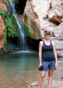
We begin seeing signs - seeps high up, green grass and trees. But nothing usable. Nothing for us. The canyon is shaded now, but the sun is still up. We push on, detouring up onto a bank to get around a boulder field. Larry spots it first - a scummy pond in the creek bed. It'll be a decent night after all, I guess. We find an outhouse sheltered under an alcove. If it is still usable is anyone's guess, but no one really wants to investigate. The next bend in the creek brings us to our campsite for the evening - sandy, with a few trees, next to the creek. It'll do. We drop our bags.
I, by a strange turn of coincidence, happen to have brought my cell phone on the trail with me. I had no plans to use it, of course, but I preferred to have it with me than having it left in the truck. With this stroke of strange luck, while Larry set up and Toad fumbled about (since Clanton had his tent poles), I climbed a nearby ridge, where I could see Navajo Mountain. To my relief but not great surprise, I could get a signal. Not enough to make a call or even send a text, but I was hopeful that a nearby spot would do. I returned to camp to set up my tent and send the check in signal via my SPOT.
I had just finished my camp setting and had laid out my camp chair when Randy and Clanton walked heavily into camp. They looked beat, and I mean beat. The shadows were growing darker, but they gamely settled into the campsite tucked against the red cliffs. Randy and I crack a Cag together and then get down to the serious business of setting up a campfire. Dinner ensues, wind lifting sand and embers together in a dark spiral into the dim evening, while we discuss egress and evacuation. I know two people with boats - one doesn't work, the other already said they wouldn't come. That leaves Clanton. The crew agrees on a hierarchy of options: friend with boat, tour boat reservation, hitchhike on private boat from dock, try and hitchhike out on tour boat. Away Clanton scampers (his knees miraculously better) up a sandstone slickrock dome to text friends and family, starting the chaos back in Page.
While Clanton attempts to communicate to the outside world (poorly, it would turn out), the rest of us relax and discuss in camp our plans for the morning. I feel like we can't make much of a plan besides getting up early and seeing what responses we've received from Pageites. I am certain word of our situation is spreading like wildfire in our gossipy little town. A shout breaks the discussion - Clanton yelling that Toad's wife (and mine) wanted to talk to us. Little did we know at the time, our text messages interrupted them in the process of hearing a story from a friend about how sometimes people clone cell phone numbers and attempt to extort money and/or services from friends. Our wives, basically, didn't believe that we were communicating with them at all. It also didn't help that Clanton's messages were disjointed and occasionally nonsensical. I shouted back up that I would deal with it in the morning. I was frustrated. I wasn't trying to text out because I didn't know the people Clanton was talking to, and as the titular leader of the "expedition", I was worried that things were starting to unravel. The idea of having a serious medical issue on the trip was definitely distressing as well.
Clanton clambered down well after dark, after a volcano of color erupted across the sky, painting the clouds a spectacular purple and pink before fading into total blackness. Our campfire sent out a faint pulse of red light into the darkness, visible only to the sky gods. The wind was picking up, and the rum only made a desultory pass around the crew before we turned in for a restless night. Wailing wind and uncertainty about the day yet to dawn kept most of us awake.

Day Two

The morning was clear and chilly. Navajo Mountain reared to our north, looming over Cliff Canyon. A brief fire to warm things up was of little use to me, for I was climbing the opposing cliff in search of a cell phone signal. I had been telling the crew on the drive to the trailhead about how the literal Navajo translation for cell phone was "the little thing that makes you climb a hill and spin around." I found myself living the definition as I scrambled past prickly pear and juniper to a little boulder field with a clear view of Navajo Mountain, already illuminated with dawn's early light.
Turning on the phone prompted a swarm of text messages. Fortunately I was able to ignore most of them - people telling Clanton they couldn't pick us up. The two biggest players on the cell phone were now just my wife and Toad's wife Emily. I sent out a credit card number and info, asking them to book us onto the boat. My wife was convinced that they wouldn't take a credit card over the phone and kept texting that back to me despite all arguments to the contrary. I'm not sure how she thought people from other countries booked boat tours, I guess. I also found out that my SPOT was not sending out my check in messages. With all this news I was getting frustrated and hungry, so I scampered back down the slope to cook some oatmeal and refill my water. I figured that nothing was going to really happen while I was up there except raising my blood pressure and lowering the phone's battery. I ate quickly as high clouds began again creeping over the sky. After cleaning up the best I could (dumping the sand from my dishes that had accumulated the previous night), I changed into the day's clothes. I was concerned about money. I don't have much, and we couldn't afford the boat if they didn't take the credit card info I sent out. Some serious discussion was undertaken about costs and options. I said that I was going to have to hike out that day due to money - but I didn't really want to split up the group. A similar idea was floated regarding the two injured parties taking the boat out, but again the group would be split (and since the other three wouldn't have our packs with us, we'd have to leave them without knowing they made the boat or face a 14 mile trek back the next day with Yabut Pass in the middle of the day, not the start). We decided that sink or swim, we were all in it together. Start together, finish together; no man left behind. The camaraderie of the backcountry is strong.
After reaching our decision to stick together no matter what, I re-climbed Cell Phone Hill. I was greeted with good news a few minutes after conversing with Ely. Emily texted me saying, "They took the card. You're booked on the boat today. It has to leave the dock at 11:30." I misread this as 10:30, but it simply provided extra impetus for us to move along. I shouted down to the camp while typing out my reply. "Let's go you bastards. We're on the pumpkining boat and it leaves at 10:30. Pack your feces! Let's move!" I signed off the phone, promising to text at the Bridge, and bounded down the slope (catching a prickly pear needle in my foot in the process).
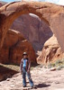
Despite my optimistic statement about being ready to move, we weren't. I certainly wasn't. Bags were still unpacked, tents still set up. With an air of urgency, however, breaking camp was accomplished relatively quickly. Our packs, re-laden with liters of water, sat heavily on our shoulders. My arms were red from the sun and our cross-country shadeless hike the day before. None the less, the trail was clear downcanyon. We bashed through the willows and plodded along the sand. We crossed the stream several times before climbing a high bank. Toad was mumbling something about a sign marking the entrance to Redbud Pass. I thought him slightly sun addled - who the hell would put in signs in the middle of the Canyon Country? But then again, someone humped those metal pipes down the trail. Still, I wasn't convinced. The high bench looked out over a large open area, with several tributary canyons leading in from the east - where we needed to head. We followed the well-defined trail down off the bench, admiring a large arch-like structure on the downstream canyon wall. The trail hit the stream...and disappeared.
We were at a loss. This looked like what we expected the junction with Redbud to look like, but there was no longer a trail. Downcanyon looked dark are foreboding, but our side canyon options didn't look terribly good either. We spent close to half an hour scouring the bench on the north side of the creek and its side canyons with no luck. Larry and I consulted a topo map that Toad produced showing the junction area in some detail. We eventually decided we were one canyon too early; that we needed to head downcanyon, past the arch/crack on the canyon wall. Time lost and the boat was moving inexorably closer to Rainbow Dock. We bashed our way through some willows and found a lost water bottle...and the trail. We hiked along the bank of the creek for a short stretch when Toad sighted a sign! Sure enough, it had an arrow pointing towards the right, and read Redbud Pass. We were in the right spot after all. Against the far cliff face we saw another old Hogan and some Basketmaker rock art. I normally spend lots of time at places like that, but I was concerned about time if we were going to make the boat. I contented myself with a water break and photographing from afar. Larry, being the superhuman hiker that he is, jogged up to the panel with his pack on and snapped some photos. Taking the opportunity to strike out ahead, I took the lead.
The Redbud Pass area gets narrow pretty fast, giant pinons and junipers rising out of the sand. A Redbud tree, fronted by an Indian Paintbrush, appears, backed by the rusty orange cliff. Toad stops and gives a brief lecture on botany. I cruise on, wanting to make time and get Randy and Clanton to the boat. The canyon bends, twists, and turns as the water-laden clouds spit rain at us, but never more than spit. As we continue trekking, we round a bend and are faced with a sudden obstacle. A sand slope, dotted with boulders, fills the entire canyon. Redbud Pass.
Despite its ominous reputation, Redbud Pass is not terribly daunting. The switchbacks are narrow and steep, but a little bit of slogging through sand and over boulders, and soon I am standing on top of the Redbud summit, by a rickety old sign saying "Redbud Pass." The others trickle up and take celebratory photos on top. I am worried about time, though, so we start to head down the other side. Larry took off out front again, and we soon came to a couple of drops where we had to sit, toss poles, and slowly scoot down off the ledge, following by some boulder-hopping. Clanton seems remarkably spry, but I say nothing. The canyon narrows up again, with inscriptions from Bernheimer and Wetherill. Blast marks mar the canyon walls as we come to the famous "man over mule" photo location. Beyond that, the canyon opens up, and the whole feel of the hike changes.
Before the base of Redbud Pass, the canyon system had been a maze of narrow slots, towering domes, and tight narrows. After leaving Redbud, we came to an open boulder-strewn field where several canyons came together, with Navajo Mountain's snow-capped cranium towering high over us. The canyons took on a different feel as we headed downstream too. The canyon was slightly wider, slightly twistier, but those weren't the source of the change. The canyons felt friendlier, more inviting. The maroon walls seemed to draw us in, not impede our progress. The creek gurgled clear, not with a steel reflection. The stretch from the base of Redbud downcanyon was also easy canyon hiking. We criss-crossed the stream many times, heads cranked back to take in the overarching walls, streaked with desert varnish. The sun came out and we took a break in the shade, eating Sour Patch Kids. This, I thought, is classic Glen Canyon hiking. Others have similar thoughts. Clanton says, "I mean, I love the lake. But think of how many canyons like this are underwater." Larry makes some sounds, I am unsure what they mean, but they prompt Clanton to continue his musings. "I mean, Glen Canyon had these beautiful streams and trees. That's why it was called Glen Canyon. It was a lush garden at the bottom."
Deep thoughts deep in the stony heart of the earth, cradled in Mother Earth's rocky arms and nursed by her clear-flowing stream of life. It is true, though, that Bridge Canyon was a veritable paradise. Green all around - junipers, pinons, grasses, reeds, Cottonwoods, all manner of native water-loving plants. Flowers were poking their colorful heads into the brisk spring air, seeing if the time was right for them. The group stretched out, three out front with two in the back. We never let ourselves get very far apart, always conscious of our collective burden.
The geology of the canyon bottom began to change. I remarked upon this to Toad as we slogged up a sand hill. "Kayenta Formation coming in. That's a good sign. Rainbow Bridge's footings are Kayenta, and the canyon isn't too deep below it. We must be getting close." We have a discussion about this, but it is soon put on hold as we spy a fence - our first since turning the truck off the paved road yesterday. Part of the gate is an old bedframe. "We must be near Echo Camp," I surmise.
Passing through the fence and regrouping, we can see a large alcove just ahead. Toad and I agree that this must be Echo Camp. There is some discussion as we wait for Randy to round the bend if we should book it for the boat or head into camp. I vote for heading towards the Bridge - based on the topo, it looks like a detour out of our way to get up into camp. The others are less certain. I call the situation Schrodinger's Boat - we can't say if the boat has left or not until we get there. The sun shines down on us all with no answers, as usual. We heft our packs and head down the trail, still somewhat undecided.
Just around the bend we catch our first glimpse of Rainbow Bridge. As titular leader of the 2011 Gay Sandfoot Rainbow Bridge Spectacular Expedition, I am at the front of the pack to get "first glimpse", and I do. It is a beautiful sight, but it quickly fades as we drop into a draw, cross a baldrock drainage, and then come to a junction with the simple sign reading "Camp" and an arrow pointing to the right. What the hell. I head towards camp.
Larry, Clanton, and Toad seem slightly confused by my sudden change. I sit down on a bedframe and explain that the sun did provide some answers. It is well past noon, I state. I stand up and hold out my hiking pole. Its shadow falls north-northeast. Past noon. Might as well drop our stuff and go down to the bridge unencumbered.
"What about Randy?" someone asks.
"Hopefully he'll come this way. Otherwise, we'll get him when we're out on the trail."
We loaf about for a few minutes, enjoying having the loads off our backs. Larry and I head into the more sheltered area to explore the pool. He hikes up into the alcove, scouting it for a possible campsite. He says it looks passable. The acoustics are amazing. We decide to make camp up in the alcove for the night. Larry and I make our way back to the entrance of camp. Since Randy still hasn't arrived, we decide to head out on the trail and find him, while Clanton and Toad putz around camp and get themselves settled. Just as we are about to leave through the gate, some people show up! What a surprise! I ask if they've seen an old, disabled, decrepit man. The two ladies don't think that 's very funny, asking why we left him by himself. No sense of humor, these Moabites and their grandson. We chit-chat for a bit, and determine that they are hiking in via The North Trail, with most of their gear being packed in by horses. That quickly tells us that if they didn't see Randy, he's heading towards the bridge. Larry and I excuse ourselves and cruise out onto the trail. We crest a rise and see Randy making his way down towards the bridge. I shout out his name, and he stops in his tracks. A few minutes later, we arrive by his side, at the entrance to the National Monument.
"We decided to head up into camp."
"Oh, I thought you guys would be hauling down to the boat."
"We figured it was after noon by the sun. The boat is gone, so we're going to set up camp and then come down and see the bridge."
"Well, I'd like to go down to the bridge and take some photos."
"We were going to come down after lunch. Are you sure?" Rain begins spattering the ground intermittently.
"Yeah. Take some photos, you know."
"Do you want us to take your pack?"
"No. It's my burden." A laugh. "It has all my camera things."
We do go with him to get the first view from inside the monument, but the rain starts coming down harder. I say, "If you're going to take some photos, I'm going to head back to camp for now and eat."
"Yeah. Wouldn't it be something to get Rainbow Bridge with a rainbow?" I agree that indeed it would be, but I want to protect my gear from drops that are coming down as more than sprinkles, and say so. "Don't you think your friends will do that for you, since they're back at camp already?"
"I prefer not to take that chance of having a wet bed tonight."
With that Larry and I jog back down the trail in the pelting rain. Of course, when I reach the fence to camp, the rain has stopped and my pack was still sitting there. No one had moved it. I chat briefly with the family again and haul my pack up to the alcove.
Randy arrives a while later, having photographed to his heart's content (though with no rainbow at Rainbow Bridge). Most of us are just lounging, enjoying the gorgeous scenery. In the deep amber pool of water below us, horses frolic. The sun and clouds paint never-ending patterns on sunburnt rock. I find a flat rock at the center of the alcove that slants towards the abyss. Unfolding my camp chair, I take a seat on it and eat my tuna fish lunch. The others perform similar duties as the afternoon continues.
Finally clear weather looks like it will stick around for a little while. The crew decides to head down to the bridge in earnest. We load daypacks and water filters (deciding to forego the horse swimming pool below us, we'll pump at the creek down by the bridge). The trail is easy and gorgeous; as I cross from reservation to monument again I wonder at my luck being able to be at this location on earth at this time. What an astounding location.
The Expedition creeps up on Rainbow Bridge, taking photos from behind trees, rocks, and other things. Only when we are close are we in the open - exposed to its full majesty. Two plaques on the north side of the bridge commemorate the native guides who brought Anglos to the bridge in 1909 - other than that, the bridge is remarkably free of human artifice. Randy walks to the shade of the bridge and soak it all in. The rest of us drop down to the shady creek bed, chasing away a couple who appears to want alone time. It turns out this was the beginning of a evening-long association with this grumpy pair.
We pumped water by the creek and did nothing except BS and admire the bridge. A more stress-free afternoon I cannot imagine. Before dropping down to the creek, I had checked the cell phone - yes there is service at the bridge. We were booked onto the boat the next morning. All we had to do now was make sure we had enough water for the evening, relax, and enjoy life.
Gradually, water bottles filled and the sun settled. The grumpy hikers left (upcanyon). We trickled up out of the creek and hit the trail, on the way back to camp. I run into a gal hiking down the trail towards the bridge. "Howdy," I offer.
"How are you? Where you coming from?"
"Echo Camp."
"No, I mean, did you take a boat in?"
"No, we hiked in. We've got a camp up there in Echo Camp."
"You didn't come in by boat?"
"No. We came in from the South Trail. Started yesterday."
"Oh. Have you seen a tall guy with gray hair on the trail?"
"Yeah, but he's part of our group. Where are you from?" That question seemed to confuse her, so I had to ask it again.
"Colorado." Nothing on this trip raised my expectations for Colorado hikers.
"Where'd you hike in from?"
"North Trail. Started Friday. We're getting picked up by boat."
I bid adieu, anxious to be away from this strange contact, and slightly slighted by her initial judgment that I couldn't make the hump over Yabut Pass. I want to get back to camp.
New guests had arrived, however - two more hikers, some horses, and the pack guides. They're out of Navajo Mountain, and the fella needed to borrow my Leatherman to fix his saddle. Meanwhile the Moabites seem awed and amazed that A) we can carry all our own gear and B) that it doesn't weigh 75 pounds like they estimated. This ain't my first rodeo, I tell them. The grumpy hikers are part of this group, and they're out of Colorado. They offer an apple slice, which I gladly accept. They talk of making frybread that evening. I joke about saving some for us. The guides and the Moabites I get along with well enough, but I want to be back with our crew. I head up into the alcove, gathering some firewood along the way. Dinner was on the horizon, but for the time being we sat and watched as the grumpy Coloradans set up their tent practically right in the middle of the trail. The horses, we were certain, would trample or piss on it for sure. At least once they were done drinking - they had returned to the pool.
Clanton straggled back in, wanting to spend some "alone time" with Rainbow Bridge. He stumbled about in the dead wood near some old building foundations, smashing into branches and making a general racket. As he stumbled back up to the alcove, he started shouting "I'm bleeding! I'm bleeding!" Sure enough, he wore a blood mustache. He dropped the wood by the fire pit and told his tale.
"I was breaking these branches off to bring up here, and when I went to pick it up, it stabbed me! It was just, like, at the perfect angle! I went for it and felt this pain. When I jumped back, I saw this branch I didn't see before. And it was covered for like a solid inch with blood! Fortunately it missed my brain, I guess. Anyone have any TP handy?"
We are slightly shocked. I hand Clanton my toilet paper. Randy refers to the device he makes from it the Nose Tampon. It certainly looks the part. Does the job too - within 10 minutes, he's feeling fine and we're eating dinner and watching the light fade over our little stretch of canyon. The fire warms us as the cool night settles in, and raucous songs of Sandfoot (usually involving the Navajo word for feces) echo through the night. The fire dies down and we trundle off to bed, ready for the conclusion of our trip the next day - no matter what it brings.

Day Three

I wake up in the middle of the night to blackness. Are my eyes open, or did I really wake at all? No stars, no reflections, nothing at all can be seen from my tightly-closed mummy bag atop squeaky springs. I roll over and see a thin line of sky. The alcove is so deep and so dark, all light disappears. I close my eyes again (for certain this time) and doze back off.
We all awake early and get our camp broken relatively fast. I was somewhat taken aback at first, because there was no ground past my feet - quite disconcerting, but I quickly adjusted. Hefting our packs, we find the packers loading their horses and the hikers already down the trail. The packers are supposed to be taking their gear down to the docks. I'm not sure how they're going to get through the fence, but I assume they know how to get around it. They've done this before.
Rainbow Bridge throws an arc-shaped shadow on the tangerine cliff to the north. We try to get some photos and then there is some discussion on how to proceed - around or under. There is no clear trail around the bridge, and a very clear one under it. None the less, all save Randy hike up and around the gravel bench on the eastern buttress of Rainbow Bridge. Hiking around, I pause and put my hand on the bridge, thanking it. Clanton snaps a picture of me, shaded by the morning shadows, with our destination. I don't know if anyone else in our group actually touched the bridge.
We mill around on the tourist side of the bridge, looking at the shadows and light, dinosaur tracks, and old dock mooring anchors. Eventually we trickle down to the docks, where the packers are indeed unloading the Moabites gear. I never did figure out how they got the horses around.
We don't spend too long at the docks until the boat arrives, bearing the day's load of tourists. We wearily dump our gear aboard the boat and make small talk with the crew (two enormous, loud men) and the Moabites (the Coloradans are still aloof). When the tourists return, the boat departs and we are on the penultimate leg of the trip. The lake glides by, slowly at first but picking up speed as we leave the confines of Forbidding Canyon. The lake is crystaline blue, and the rocks red-orange towering above us stand like majestic monuments. It is not the same, though, as a hike through the same canyons would be. It is more of a view and less of an experience. The boat tourists head belowdecks while the hikers and us backpackers brave the chill wind for the awesome view.
The rest of the trip occurs in a blur. The shuttle up from the docks, waiting for the shuttle eating some ice cream, the truck ride in Randy's F-150 out to the trailhead. We toasted my truck being intact with some Samuel Smith, Cheetos, and Salt and Vinegar chips. Then back on the road to Page for some after-hike celebratory beverages and calzones at Strombolis. Randy, Larry, Toad, Clanton - it was a hell of a hike and an awesome birthday. I can't wait to hike with each of you again.
wildflower observationwildflower observationwildflower observationwildflower observationwildflower observation
Wildflowers Observation Moderate
_____________________
"The only thing we did was wrong was staying in the wilderness to long...the only thing we did was right was the day we started to fight..."
-Old Spiritual
My book, The Marauders on Lulu and Amazon
 
Apr 02 2011
avatar

 Guides 71
 Routes 98
 Photos 9,967
 Triplogs 1,009

65 male
 Joined May 14 2003
 Ahwatukee, AZ
Rainbow Bridge via South TrailNortheast, AZ
Northeast, AZ
Backpack avatar Apr 02 2011
Randal_SchulhauserTriplogs 1,009
Backpack13.18 Miles 2,794 AEG
Backpack13.18 Miles3 Days         
2,794 ft AEG
 no routes
1st trip
Linked   linked  
Partners partners
PaleoRob
squatpuke
ToadOfTheRocks
Rainbow Bridge 2011

I've had this iconic destination on my "wish list" since moving to Arizona in 2003. The fact that this natural bridge wasn't "discovered" until August 1909 only adds to the allure. Organizing a trek to the bridge in present times proves fleeting as attempts in 2009 and 2010 were scheduled and ultimately canceled. But campfire discussions during last year's treks to Grand Gulch and Chaco led to an agreement that the first weekend in April 2011 would be targeted. I blocked out a 4 day weekend on my calendar and Casa Grande Rob posted the HAZ Event => [ 2011 Rainbow Bridge Spectacular ]

The trek began Friday April 1st with my F-150 hitting the road on the back end of morning rush hour traffic. Stopped for a chilli bowl lunch in Flagstaff at the Beaver Street Brewery and purchased a Rail Road Stout growler for some post-hiking consumption. Picked up Larry (aka squatpuke) at a designated rendezvous spot at the east end of Flagstaff. I met Mrs. Squatpuke as we transferred Larry's gear into my F-150 and indicated to her that we'll see her again late Monday.

Stopped along Hwy 89 to check out the Wupatki roadside kachinas and pondered Rainbow Bridge and Navajo Mountain significance to the Hopi. Larry and I checked into our Friday night base camp at the Holiday Inn Express in downtown Page AZ and walked to our designated evening gathering spot, The Fiesta Mexicana Family Restaurant at 125 S. Lake Powell Blvd. Our group soon assembles; PageRob, squatpuke, Toad, Clanton and various Page residents (seems that everyone in Page knows each other) at our table on the front patio. Final hiking plans are made with and agreed 5am meet-up Saturday morning at Rob's house.

Alarm rings 4-ish on Saturday morning, check out of our base camp and meet up at Rob's for coffee and truck-pooling. We soon depart from Page following Hwy 98 about 50 miles towards Kayenta. At the intersection of IR16 (aka Navajo Mountain Road), we head north towards Inscription House and Navajo Mountain. I'm surprised that our drive has been confined to paved roads until we reach our IR161 cut-off (about 33 miles from Hwy 98). Our trail notes indicate rodeo grounds with water tank on the west side and signage for "Navajo Mountain School". More confidence we're on the correct dirt track when I spot an IR161 sign. We spot Haystack Rock having traveled about 5 miles and take the dirt track towards Navajo Mountain. There's a well at War God Springs where a local is filling up his tanker truck. He points out the double-track heading towards our TH at Rainbow Lodge ruins. The double track rapidly deteriorates. Rob's Explorer requires a spotter at multiple points to negotiate around tire sidewall slashing and differential smashing rocks. At another split in the double-track, we choose the right split towards a water tank (wrong turn!). We retrace our tracks and get back on course arriving at the Rainbow Lodge ruins and the elusive TH.

Having explored the ruins and posed for a TH group shot, we position those heavy packs on our backs and hit the South Trail (aka Rainbow Lodge Trail). We soon drop into appropriately named "First Canyon" and pop up onto a bench with elevated heart rates. Horse Canyon soon comes into view with a rather insane downward grade (check out photo evidence) to the bottom wash. Having exited Horse Canyon, we drop our packs for some refreshments, snacks, and photo ops.

Back on the trail again across some benches and unnamed washes until we reach Yabut Pass. My jaw drops. The shear wall drop and a trail visible in the bottom canyon leave you scratching your head - How do you get down there?

Arriving at the bottom of Cliff Canyon, I realize this is a toll trail and I've paid with my left hip and knee. Clanton is feeling the same way as we spot some cottonwood trees and begin hearing a cacophony of canyon frogs. That has to be Cliff Canyon Springs just ahead and our designated Camp #1.

As we set up camp, Rob and I share a traditional Cag => [ photo ] My hip and knee make an instant recovery without having a 50lb pack strapped to my back. As the day light wanes, we're treated to a "purple haze" sunset and a continuing cacophony of canyon frogs. The evening camp fire is toasty and comforting as the group discusses changing from "Plan A" to "Plan B" => exit via the Lake Powell water route rather than the South Trail "in-and-out". With that settled and the winds beginning to pick up, time to turn in and call it a night.

Sunday morning we break camp and head downstream towards Redbud Pass. The trail becomes confusing at the confluence of multiple side canyons into a wide basin. We make a minor detour into blind canyon, but soon correct ourselves finding the "Redbud Pass" signage => [ photo ]

We spot some Basket-Maker vintage rock art on the walls of Redbud Pass. Redbud soon becomes a narrow slot with evidence of the original dynamite blasting from the 1920's. Upon cresting Redbud Pass, it's all downstream from here. We are soon at the confluence of Bridge Canyon and merge with the North Trail (aka Discovery Route named after the 1909 expedition).

As we pass through a gate into the Echo Camp Basin area, I can sense the presence of our main objective nearby - RAINBOW BRIDGE!
"Out of the shade, into the heat. I tramp on through the winding gorge, through the harsh brittle silence. In this arid atmosphere sounds do not fade, echo or die softly but are extinguished suddenly, sharply, without the slightest hint of reverberation. The clash of rock against rock is like a shot - abrupt, exaggerated, toneless.

I round the next bend in the canyon and all at once, quite unexpectedly, there it is, the bridge of stone.

Quite unexpectedly, I write. Why? Certainly I had faith; I knew the bridge would be here, against all odds. And I knew well enough what it would look like - we've all seen the pictures of it a hundred times. Nor am I disappointed in that vague way we often feel, coming at last upon a long-imagined spectacle. Rainbow Bridge seems neither less nor greater than what I had foreseen.

Through God's window into eternity.

Oh well. I climb to the foot of the east buttress and sign for Ralph and myself in the visitor's register. He is the 14,467th and I the next to enter our names in this book since the first white men came to Rainbow Bridge in 1909. Not many, for a period of more than half a century, in the age above all of publicity. But then it's never been an easy journey. Until now..."
- Edward Abbey's "Desert Solitaire", pp240-241.
Larry, Rob, Toad, and Clanton have made a detour into Echo Camp to set up camp early in the Alcove. I press on, drawn by the magnetic allure of RAINBOW BRIDGE. I can sense it and as I cross the National Monument fence and gate exiting the Rez and rounding the bend, it's there!

Sunday evening camping in the Alcove, we recreate scenes from the 1913 Teddy Roosevelt visit as we roll out our sleeping bags on the metal bed springs that have served campers since that time. Our evening fire heats up the entire Alcove as I fall asleep under the stars.

Monday morning we break camp at dawn, photograph Rainbow Bridge from every possible angle and catch the Tour Boat back to Page AZ => [ photo ] . The Tour Boat shuttle bus takes us to Rob's house where we grab my truck and make the trek back to Rainbow Lodge ruins to retrieve Rob's vehicle => [ photo ]

Thanks to Rob for pulling this all together. Good to meet Toad, Clanton, and Larry making this a truly memorable adventure! Got to have a redux soon via the "Discovery Route" aka the North Route => [ Rainbow Bridge via North Trail ]

RANDAL SCHULHAUSER - April 2011
wildflower observationwildflower observationwildflower observationwildflower observationwildflower observation
Wildflowers Observation Isolated
_____________________
 
Apr 02 2011
avatar

 Guides 2
 Routes 1
 Photos 56
 Triplogs 5

50 male
 Joined Dec 02 2006
 Page, AZ
Rainbow Bridge via South TrailNortheast, AZ
Northeast, AZ
Hiking avatar Apr 02 2011
ToadOfTheRocksTriplogs 5
Hiking13.18 Miles 2,794 AEG
Hiking13.18 Miles
2,794 ft AEG
 no routes
1st trip
Linked   none no linked trail guides
Partners partners
HAZ - Event
PaleoRob
Randal_Schulhauser
squatpuke
Rainbow Bridge Spectacular:
First day--started out good, but a little late. We climbed the first three canyons with no real difficulty (up and down and up and down). We got to Yabut pass and peered down a 2000 ft drop that would be done in two miles. WOW! The origin of the name Yabut Pass eludes me but I think that the first expedition found the way better than the impassable canyon, but still thought it would kick ya but. The decent was steep and difficult, especially with 50lb+ packs, bad terrain and a poorly maintained trail. At the bottom, some of our team members expressed a reluctance (downright no way) to return this way as planned. This changed our plans to hike in 8 miles, base camp at first water, then day hike to the bridge and back. We camped at first water, a lovely spring and creek with pure clean water. Well, we thought it was clean until we saw dozens of mating canyon tree frogs in the course (time to get out the filter). The randy frogs regaled us with beautiful song all night, only to be drowned out by 30 mph winds.
The next day, after Johnny C. (friend from Page) had spent hours texting from a high rock, with a view of Navajo Mountain (only guarantee of signal in these here parts) we secured passage by tour boat for the reluctant round trippers. Before we left, we made a unanimous decision to break camp entirely and rush down to the Bridge to get on the boat. We couldn't break up the party because if anything went wrong we needed everything. We sped through to the Bridge, with one minor loss of direction, ( I blame the pace, not my extraordinary navigational skills ) then up and down Redbud Pass out the canyons to catch the shuttle. The shuttle was to leave at 11: 2Oish, we got there at around 11:30 missing it. We had arranged to get a pick up the next day if we missed, so we were fine with it. I was secretly happy to spend another day with the Bridge, but I knew that retrieving our vehicle, now a nearly 100 mile trek by car from the marina, was priority. We set up camp in the historic Echo Camp. This camp was used for sleeping quarters for tourists in the early days, before the lake encroached. These tourists included such folks as: Teddy Roosevelt, Barry Goldwater, Zane Grey and many others. This camp was a massive alcove big enough to hold 10-20 campers comfortably. The original steel spring beds were still there and usable, a wonderful respite for us from the ground and threatening rain. After a pleasant nights, sleep we set out early to hang out with the Bridge for a few hours, before our water coach arrived. This time was spent yoga like stretching, playing in the creek and using up our camera memory cards, and the rest of our food. Food and water could be consumed freely now knowing that the presence of another group (with horses and Navajo guides to ease their travel) was a true sign that our boat, and apparently their boat, was coming. Soon the boat, and simple, lazy tourists, piled out to see the Bridge, while we piled in to drink the rest of the free ($60 boat fee) lemonade. Our grand plans were dashed by circumstance, but we still got to see one of the most beautiful hikes in the entire country. Plus,the unexpected night a Echo Camp,which was a wonderful expiriance, would have never happened. I can't wait to go back and do it again, this time with more time. Anyone that wants to go maybe in October, preferably next April to get full flower potential, let me know. Thanks alot to PageRob for planning, permits and transport. Very much appreciated.

Hey Mr. Music
Ya sure sound good to me
I can't refuse it
What got to be, got to be
Feel like dancing
Dance cause we are free
I got my home
In the promise land
But I feel at home
Can you understand
Said the road is rocky
sure feels good to me
and if you're lucky
together we'd always be
Are you really riding?
the sun is a risin' the sign is a risin'
Moon is rising
Are you really riding? Are you really riding?

Rainbow country Rainbow country
Bob Marley
 Flora
 Flora [ checklist ]
[ checklist ]  Serviceberry
 Culture
 Culture [ checklist ]
[ checklist ]  Inscriptions
wildflower observationwildflower observationwildflower observationwildflower observationwildflower observation
Wildflowers Observation Moderate
_____________________
 
May 13 2006
avatar

 Guides 2
 Photos 20
 Triplogs 3

83 male
 Joined Dec 27 2004
 Glendale, AZ
Rainbow Bridge via South TrailNortheast, AZ
Northeast, AZ
Hiking avatar May 13 2006
BenTriplogs 3
Hiking13.00 Miles
Hiking13.00 Miles2 Days         
 no routesno photosets
1st trip
Linked   none no linked trail guides
Partners none no partners
A Trail So Rough That Even Freud Would Slip

It was early afternoon. A gray whale with seven eager hikers in its belly bumped over a road more suited to camel and jackass travel. The 4x4 crew-cab long-bed ¾ ton Dodge diesel carried these humans who had experienced psychological damage from years of city living back into the wilderness of their ancestors. They were seeking the beauty of nature and some relief from the pressures of cell phones and urban confusion. They were ready to backpack.
The trek was to begin at the historic Rainbow Lodge ruins and end with a ride across the earth's only monument valley on water. In 1909, John Wetherill led a couple ego maniacs across the deep canyons leading to the 300 foot high Rainbow Bridge. Immediately after this official discovery,, Americans with more money than brains wanted to see the newly publicized natural wonder. Nealy 100 years ago, the Richardsons, a family of Navajo traders, built Rainbow Lodge and forged a trail to the bridge for use by paying customers. Rainbow lodge, later owned by Barry Goldwater, was closed and burned to the ground over 50 years ago. The stone ruins remained on the southern flank of beautiful 10,388 foot elevation Navajo mountain and overlooked the deep finger maze canyons surrounding Cummings Mesa.
The first day, the crew that included Susan Richmond, Gary Johnson, Kathy Gindt, Roger Fournier, Lorna Peterson, Tim Blaser, and Ben Barstad made tracks for three miles while watching shadows of the late day sun move across red sandstone monuments. Tim turned back so he could make it to pavement with the Dodge whale before darkness left him lost in the reservation wilderness. He drove to Page and, as the shuttle driver, would meet the hikers at Wahweap two days later. The remaining six trekkers would camp at the first somewhat level spot they could find. Ben stretched out on a slab to enjoy a few minutes of comfort while a leaky air mattress deflated. Gary also slept in the open. The tent occupiers left the rain flies off so the beauty of deep space, only visible with the human eye where clear air and natural darkness prevailed, could be enjoyed by all. Lorna was able to watch a falling star shoot to earth.
This adventure was, as it should have been, not easy. The trail had deteriorated over the last 50 years and was covered with large and small rocks. Susan was shocked that it was not all downhill to the bridge destination. Wildlife was rare. Lizards were often seen and our lizardologist, Gary, was able to identify a rare Yellow Headed Collared Puff-Necked Lizard. and a Septicannus Brown Lizard. Everyone was impressed. Roger was excited. The Navajo Nation had given the crew a one page map that covered the entire area on an 8 ½ by 11 inch paper. "It ain't that long a trial." Roger told the crew. Roger loved his short trail map. Kathy attracted insects. Therefore, she wore a bee keepers hat through the entire backpack. Lorna ran into every thorny plant the desert had to offer. She was soon referred to as Thorna. Ben tried a shortcut off the mountain. Fortunately his tumble stopped about eight feet down. Gary, with his EMT training, plugged Ben's leaky skin so the two mile trip down the 1500 foot talus decline could continue. While Ben was hanging onto a rock over the edge, Lorna informed him, "Ben, that is not the trail." Ben had already reached that conclusion by himself.
Redbud Pass had been blasted by the Richardsons so jackasses, as pack animals, could ninety years ago, carry the goodies of those who were too lazy to do it themselves. The pass had become worse over the passing decades. Fantastic to look at, with high narrow walls of Navajo Sandstone decorated over the thousands of years with desert varnish, the pass was a true challenge. Once the crawling and scrambling had taken the trekkers to the top and back down the other side, Gary officially renamed it Red Butt Pass. He considered, but rejected, the name Sore Butt Pass.
Shortly before the water supply was exhausted, pools of water for filtering were located in Cliff Canyon. The last miles of the hike were fortunately less torturous for the tired travelers. When approaching Echo Camp, the hikers saw their first additional human figure. "He looks like Doctor Seuss." Thorna laughed. It turned out to just be some cat in a hat. Tim had bounced his jet ski 51 miles to Rainbow Bridge so he could also check out deep space and hear stories of near death experiences. Knowing that his clean rested persona could cause resentment on the part of this collection of bruised, limping, and stinking wilderness travelers, Tim had brought an offering. His small cooler of cold beer and soda pop made him seem godlike to all. Roger was captured, on film, in a position of worship to the cooler.
The last day, Gary was able to identify a short-tailed Carp. Then, the tour boat arrived and allowed the crew to relax and watch the wonders of Lake Powell pass by. The last night was spent at Camp Grandview, where everyone was able to shower, use facilities of civilization, and eat great tasting Mexican food someone else had prepared. The backpacking experience had prepared everyone to face the less natural civilized world again.
When all the façade of civilization was removed, individual psychology, both normal and abnormal, was displayed. It had also become possible to make some observations of hiker mental state and develop reasonable speculations.
Susan never stopped walking. She kept mumbling, "Keep on ticking." Did she possess a secret desire to become a Timex watch or Energizer Bunny? Tim had a great new many mega-pixel camera. Why did he try to take pictures under water. Did he possess some psychological need to test the warranty process? Did Roger suffer from cold beer fantasies? Was Kathy so altruistic that she intentionally attracted insects away from others? Ben took twelve great pictures. Then he put film in his camera. Did he suffer from digital camera envy? Lorna really wanted to find some less weighty dehydrated water for her next backpacking adventure. Was she absent from science class that day? And finally, Gary Johnson, when describing a Jackass Canyon hike, would slip and call it Johnson Canyon. His eyes also twinkled when he identified creatures. Was he afflicted with pumpkinosis?
Lumpy and limping, the crew returned to the greater Phoenix area with smiles. They had seen views reserved for those willing to get out and be there They also knew they could make the trip and were even willing to face new adventures. It was a great trip..
_____________________
 
May 07 2006
avatar

 Guides 4
 Routes 29
 Photos 1,691
 Triplogs 467

male
 Joined Sep 08 2002
 Ahwatukee, AZ
Rainbow Bridge via South TrailNortheast, AZ
Northeast, AZ
Hiking avatar May 07 2006
SredfieldTriplogs 467
Hiking27.50 Miles
Hiking27.50 Miles4 Days         
 no routesno photosets
Linked   none no linked trail guides
Partners none no partners
Did this one yet again, same route, SW trailhead to the NW. Water was readily available in all named canyons, and at Echo Camp. We camped 2 miles in from SW TH, then Echo Camp, and Surprise Valley.

My previous posts on the trip do not convey that it is a strenuous trip, owing possibly to my selective memory. This route is not to be attempted by those not accustomed to backpacking.

Roads to the trailheads continue to be brutal, but passable.

That being said, it is one of the best hikes in the SW, in my opinion.
_____________________
Shawn
The bear went over the mountain to see what he could see.
 
May 04 2006
avatar

 Guides 20
 Routes 13
 Photos 3,189
 Triplogs 451

female
 Joined Mar 31 2002
 Chandler, AZ
Rainbow Bridge via South TrailNortheast, AZ
Northeast, AZ
Backpack avatar May 04 2006
desertgirlTriplogs 451
Backpack26.00 Miles
Backpack26.00 Miles4 Days         
 no routesno photosets
1st trip
Linked   none no linked trail guides
Partners none no partners
Awesome! Slickrocks, sunsets and of course the Rainbow Bridge...Back from a delightful trip with Guru,Tracy and Shawn...This was totally awesome ...
_____________________
 
Apr 14 2006
avatar

 Photos 24
 Triplogs 11

57 female
 Joined Sep 24 2005
 Sedona, AZ
Rainbow Bridge via South TrailNortheast, AZ
Northeast, AZ
Backpack avatar Apr 14 2006
tokayoTriplogs 11
Backpack29.00 Miles
Backpack29.00 Miles3 Days         
 no routes
1st trip
Linked   none no linked trail guides
Partners none no partners
:sweat:

This was quite something! It was more of a challenge than any of the books said, mostly because there's no way to account for all of the consistent feet gained and feet lost. The trail was relentlessly up and down and covered with loose rocks, deep sand and river rocks. That said, this was an incredible trip. In the Spring months, you'd be fairly safe assuming you could bring a water filter and find water from First Canyon onward, but during the summer, you'd better be prepared to do some long, hot, tough, shadeless hiking with gallons of water strapped to your back!
_____________________
 
May 06 2005
avatar

 Guides 4
 Routes 29
 Photos 1,691
 Triplogs 467

male
 Joined Sep 08 2002
 Ahwatukee, AZ
Rainbow Bridge via South TrailNortheast, AZ
Northeast, AZ
Backpack avatar May 06 2005
SredfieldTriplogs 467
Backpack27.50 Miles
Backpack27.50 Miles5 Days         
 no routesno photosets
Linked   none no linked trail guides
Partners none no partners
Did this hike again, this time with Mark, Ron, and Dave. We camped a mile or so in from the south TH the first night, night two was in a beautiful spot south of Redbud Pass. We dropped our packs just over the pass at the junction of two trails and hiked down to the Bridge for a couple hours, then back and to the east to the last water. Nice camp spot there. Day four was up on the plateau to Bald Rock Canyon for the last night. Out in a couple hours the last day.

All very spectacular as before. This is one of the "must do" back pack trips in the SW, in my opinion. We found water in all named drainages, and a few more. The longest dry stretch is from Rainbow Lodge to the first canyon, down the big hill. The trail just south of the pass was more than I recalled, very interesting stretch of trail through the rocks and talus. We met 6 Colorado hikers at the top; I'm glad we were not going their direction; it is a 1500 foot pull up that hill.

An in and out from the NE trailhead would not be bad, but purists will do the car tricks and see it all. The shuttle is a pain, the road in to the lodge ruins is pretty bad and getting worse, good tires and high clearance required. The good part is that it is only a mile or so and it keeps the vandals out.

All in all, a very wonderful trip.
_____________________
Shawn
The bear went over the mountain to see what he could see.
 
Nov 08 2003
avatar

 Guides 4
 Routes 29
 Photos 1,691
 Triplogs 467

male
 Joined Sep 08 2002
 Ahwatukee, AZ
Rainbow Bridge via South TrailNortheast, AZ
Northeast, AZ
Backpack avatar Nov 08 2003
SredfieldTriplogs 467
Backpack27.00 Miles
Backpack27.00 Miles4 Days         
 no routesno photosets
Linked   none no linked trail guides
Partners none no partners
Rainbow Bridge

Reference book: Hiking the Southwest's Canyon Country by Sandra Hinchman.

Access: From Tuba City, AZ. Northeast on highway 160 ~40 miles to highway 98. Left on highway 98 ~12 miles to highway 16. Right on highway 16 ~34 miles to Y-junction with highway 161. The route is paved to a few miles short of this junction.

To the NE trail head: From the "Y" take the right fork ~12 miles. You will pass the turn off to Navajo Mountain Trading Post, and another to the small community of Rainbow City. At the intersection at Rainbow City, proceed straight onto the dirt road for the last 3.5 miles over primitive road to the trail head on the south side of a rock mound.

To the SW trail head: From the "Y" proceed northwesterly along road 161 ~5 miles to a road to the right. The water tank noted on the 7.5 minute topographic map is visible from just before this intersection. The road quickly deteriorates into a rugged trail ~2 miles to the remains of Rainbow Lodge. The road is rock strewn and rugged, but our 2WD Ford Explorer managed it easily.

Rainbow Bridge, on the Navajo Reservation, is the largest natural bridge in the world. Hinchman says the trip would be well worth the time and effort without the Bridge, a statement with which we enthusiastically agree. Two trails lead to the Bridge, one from the south, the other from the east. Together they nearly half-encircle Navajo Mountain.

Permits (required) from the Navajo Nation Parks and Recreation Department are available by mail (P.O. Box 2520, Window Rock, AZ 86515-2529 (928-871-6451). For unexplained reasons, allow several weeks to receive the permit by mail. Or pick the permits up in person at one of several offices on the reservation. (Cameron, Antelope Canyon, Monument Valley, or Window Rock) The Navajo Nation is not responsible for vandalism at the trail heads, an oft-noted problem but one we did not encounter. Trail heads are quite remote.

We (Beth, Jarod, Mary, Robert, Shawn) did the hike clockwise from the Rainbow Lodge trail head on the slope of Navajo Mountain to the northeastern trail head. Setting up the shuttle vehicles (car tricks as Robert called it) took about ninety minutes. This trail head is in Arizona (which makes the hike suitable for HikeAZ.com), you cross into Utah about a mile down the trail.

We found the trail well marked and in good condition, despite reports that it is not maintained. It wanders up and down circling around the western flank of the mountain. Some steep stretches provide a good workout, but none are overpowering. Take a few breather stops to enjoy the slick rock views to the west. At Sunset Pass the trail passes through a small opening blasted through the wall atop the ridge. Look for the tell-tale starburst blast pattern in the trail bed.

The trail descends rapidly into Cliff Canyon from the pass. Take your time and enjoy the expansive views down canyon. First water is down there somewhere. We found it below the mouth of a large unnamed canyon on the right (east). Water was a concern our entire trip due to the extended drought cycle at the time and because we found no authoritative source of information; everyone we contacted said there was none. However, and to our chagrin after carrying extra most of the trip, all the named canyons along the route were flowing.

Campsites are just down stream from the junction mentioned above. Hinchman suggests marching on to some alcoves a mile past these campsites. We did not find the alcoves, and felt the first sites were just fine, especially after our late start. There is a rather attractive open area at the turn up to Redbud Pass and this would certainly be a nice camping area. We found horses grazing here, and some old log structures. The rock art Hinchman mentions is on the north wall of the canyon directly north of the sign noting the route to Redbud Pass. The trail ascends a few feet from the stream side to the meadow and the sign comes into view, look north to some faded spots near the base of the wall to the north.

Our search for the rock art also yielded a juniper grove with a nearly intoxicating aroma in the west end of the meadow.

The trail enters Redbud Pass, which contrary to Hinchman's sketches, is not two canyons, but one slot plugged by a talus pile. The talus seems very out of place amidst this slick rock world, but to corrupt a cliché geology happens. We were rather mystified by thoughts that this is or was a horse route. Perhaps it has deteriorated; several areas require scrambling and hand holds, nothing to hinder foot traffic but certainly too steep and rough for horse travel.

Dropping into Redbud Canyon, the trail turns left, then soon joins with the route down Bridge Canyon. We noted a larger than usual cairn at the junction. We missed the ruin here that Hinchman mentions, probably because we were focused on reaching the bridge. Continue downstream from the junction across a slightly wooded camping area. The trail braids here but all strands lead downstream to the obvious and well-cairned route. It becomes somewhat serpentine for a mile or so, twisting along below the sandstone walls until the stream bed drops away and the trail stays level. Watch for, but do not take, a steep branch down to the bottom of the stream bed. As you make your way around to the left, keep a watchful eye down-canyon. We found the first appearance of the bridge something of an optical illusion, not readily apparent. See if you do.

The trail divides just after crossing a tiny drainage, one branch goes to Echo Camp, the other to the now-obvious bridge. Echo Camp is the remains of commercial tourist operations prior to Lake Powell and the bridge becoming accessible by boat. The most notable feature is the many steel beds littering the area. In spite of being an eyesore, several in our party found them very comfortable sleeping. The camp is aptly named; the alcove has near-perfect acoustics and light voices are audible great distances in and around the alcove. A small marsh is the head of flowing water at the camp.

The bridge is just a short distance over nice trail from the camp. Note the plaques commemorating the Native guides on the discovery trip.

We enjoyed a full moon, with an eclipse!! our night in Echo Camp. Rainbow Bridge in moonlight so bright you do not need flashlights to find the trail is quite a sight. (Can we time a trip or what?)

Going out to the east requires a back track up Bridge Canyon. At the junction with Redbud Canyon stay left to remain in Bridge Canyon, which here is very narrow but soon opens up a bit. Hinchman advises watering up before leaving Bridge Canyon, but did not reveal how to distinguish the "last water" from any other. We found the trail up out of the canyon, then back tracked a few hundred yards to that last water.

From here the views change from canyons to open bench lands. The trail changes often, crossing sagebrush flats, dropping into small canyons and arroyos, traversing slick rock reaches, and generally keeping you interested. There are no large hauls up or down, but like the first day, enough elevation change in small doses to keep your heart pumping. The views of Navajo Mountain are incredible, and you can take heart in how few people ever get the chance to see it from this remote vantage point.

As the trail descends into Surprise Valley, look for Owl Bridge to the right, followed quickly by the remains of a hogan on the left. Go a short distance farther to the stream crossing, and look for the rock art-a rather modern horse-on the wall to the right of the trail as it begins its ascent. The "discovery" expedition camped in Surprise Valley August 12, 1909, the night before reaching Rainbow Bridge. (Accounts conflict, by some accounts it was August 13th.)

Again the route takes you up onto the bench lands for spectacular views of the red slick rock. We had the good fortune of an overcast sky on our third day, which brought out the orange of the rock to the point that it was almost luminescent. Camp number three was in Bald Rock Canyon just downstream from where the trail crosses the stream. A light rain on the tents serenaded us through the night.

Out of camp a bit early we headed for the car. The scenery remained spectacular, with views of snow-flecked Navajo Mountain through the mist, and the low clouds accentuating the red of the rocks to the north. The book says three miles to the trail head from Bald Rock Canyon; it is a bit further, especially with a bad case of "trailheaditis." We reached the car in just under two hours to find it safe and secure. The rain and perspiration had us quite soaked; the heater felt wonderful. A quick drive to the southern trail head where we found the other cars equally sound, and we are off to Cameron for a hot meal.

There are several variations of the trip, including one way hikes into the bridge and meeting up with a tour or charter boat. Both the north trail and the trail from the southwest are spectacular, I wouldn't miss either.

Links:
NPS History of the discovery expedition:

http://www.nps.gov/rabr/adhi/adhi3a.htm

Troubling quote:
Even Cummings contended that Douglass was in the midst of jockeying for position so as to ensure his claim to being the first white man to see Rainbow Bridge. Cummings later remembered:
After we negotiated the difficult Red Bud Pass [on the eastern side of Bridge Creek], Mr. Douglass, Mr. Wetherill, Noscha Begay [sic] and I halted in the shade of a cliff to let the packs catch up with us.
What's troubling? The maps show Redbud Pass west of Bridge Creek, and the expedition approached the bridge from the east.
_____________________
Shawn
The bear went over the mountain to see what he could see.
 
May 15 1994
avatar

 Guides 1
 Triplogs 237

79 male
 Joined Feb 04 2002
 
Rainbow Bridge via South TrailNortheast, AZ
Northeast, AZ
Hiking avatar May 15 1994
sidhayesTriplogs 237
Hiking26.00 Miles
Hiking26.00 Miles   7 Hrs   34 Mns   3.44 mph
 no routesno photosets
1st trip
Linked   none no linked trail guides
Partners none no partners
Hiked into Rainbow Bridge via South Rainbow Trail, lots of ups and downs, and returned via the North Rainbow Trail. Both have great scenery, perhaps the best I have ever seen. Had bicycle parked near North Rainbow trailhead and rode back to the start.
_____________________
 
average hiking speed 2.24 mph

WARNING! Hiking and outdoor related sports can be dangerous. Be responsible and prepare for the trip. Study the area you are entering and plan accordingly. Dress for the current and unexpected weather changes. Take plenty of water. Never go alone. Make an itinerary with your plan(s), route(s), destination(s) and expected return time. Give your itinerary to trusted family and/or friends.

helpcommentissue

end of page marker