|
| | | Chitty Falls-Creek backpack loop, AZ | | | |
|
|
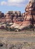
Chitty Falls-Creek backpack loop, AZ
| | |
| |
|
| Backpack | 19.00 Miles |
2,800 AEG |
| | Backpack | 19.00 Miles | 23 Days | | |
| 2,800 ft AEG | | | | |
|
|
| |
| Partners |
|
none
[ show ]
| no partners | | From Alpine drive south on US191 for 33 miles to the Strayhorse campground. Park on the east side of US191 in the parking lot. The trailhead is on the west side in the campground by the closed road.
Trail Description:
Updated Memorial Day, 2011
BFB's (Beautiful Forest Bovine) 400 head were put in this area April 2011 Four Drag Ranch
The trail begins at a closed road in the Strayhorse campground. Follow the road about .2 miles to the single track. From here, the Highline Trail #47 begins climbing and dropping in and out of drainages in a burned area. Approximately 1 mile in it gets a bit confusing- look for large cairn marking first trail jxn south- you go straight on to Crabtree Park. Just over the next ridge you will find the signed junction with the Crabtree Trail #22. Continue straight for the Highline Trail.
The Highline trail then begins a steep climb along drainage before switch backing up to high point of the hike (7800 feet). After a mile or so up high, the Highline trail switchbacks down before reaching Salt House and a side canyon to Salt House Creek (3.4 miles from the trailhead). At 3.6 miles you reach the signed junction with the Salthouse Trail #18. Continue straight on the Highline trail, which is also the Salthouse Trail for the next .4 miles. At 4.0 miles from the trailhead, turns right on the Highline trail while the Salthouse Trail continues straight ahead. There is a corral about a tenth of a mile further down trail if you want to check it out. Head RIGHT From the junction, the Highline trail climbs aggressively and switchbacks a couple of times. Ups and downs for several miles through several drainages until at 6.4 miles in it drops precipitously into Chitty Creek. At one point 2 trails appear; you want to head down into the creek where there is a sign.
Once you get to the bottom, Chitty Creek is beautiful. A perennial creek, it is the first real water in the entire hike. .3 mile after you reach the Chitty Creek, the Highline trail again heads off to the west. Stay on the Chitty Trail #37 following the creekbed. Within a few feet of the junction with the highline trail is Chitty falls-- a very nice 15 foot water fall-looks like the falls and pool area have filled in a bit since last report of 2003. No camping immediately near the falls, but there is a nice site 1/3 mi below. We left the coffeepot, mugs, fork and spoon out for you. ? At this point you have gone ~ 7 miles
Chitty canyon is narrow and densely populated with oak and walnut trees; follow the canyon and blazes. A nice day loop of ~4 miles is to go back to jxn, up bear creek, head south at jxn on ridgeline, and loop back to Chitty Canyon and back to camp. Advise going CCW on this short loop. Alternatively, head ~2.1 miles up Chitty to its headwaters.
Continuing in Chitty canyon, you will come to a small drainage coming in from the East at an old corral on East side of creak; continue down Chitty and you will see both old and new trail signs for jxn Salthouse. The creek has gone underground in areas and water may be unreliable here. Salthouse canyon is wider and more open than Chitty canyon. About a mile below the junction with the Chitty trail, you will encounter an old corral. Head east on south side of Eagle Creek and you will see the tank and signs. East Eagle Creek Trail #33. Back at the junction, about 50 feet in you will see Eagle Tank to your right. The trail follows the creek and in a few hundred yards reaches a fork. To the right is Hot Air Canyon- War Finance Trail. To the left is the East Eagle Creek trail. Hike ~1/4 mile and sign to your right- Cross the dry creek and continue on the East Eagle Creek Trail heading east. NO water in EEC
The canyon itself is wide and populated with pine, oak and walnut trees.
Twelve miles from the start of hike, you will reach the NOW SIGNED junction with the Crabtree Trail #22. The trail heads off to the left. At this point it is 5.5 miles to Hwy 191 and relatively flat, and 7.5 miles to Hwy 191 Strayhorse, with climbing. AN easier loop would be to set up a car shuttle and come out EEC vs. Crabtree. Crabtree Creek was dry on the bottom 3 miles. We saw NO water Walnut Tank, but there are intermittent springs in Crabtree and in dry 2011 they had water.
Crabtree canyon opens up near the top and is a beautiful meadow near Crabtree spring. At one point a new fence comes in and we got on the W side of it, and at one point had to slide under it to get onto the trail. The last .5 mile of the canyon is a bit steeper than the rest but still not too bad. The trail ends at the Highline Trail # 47. Turn right and it is 1.4 miles back to the trailhead at Strayhorse campground |
| _____________________
| | |
|
|
|
 Route Editor