|
| | | |
| |
|
| Hiking | 6.50 Miles |
450 AEG |
| | Hiking | 6.50 Miles | | | |
| 450 ft AEG | | | | |
|
|
| |
| Linked |
|
none
[ show ]
| no linked trail guides |
| Partners |
|
none
[ show ]
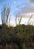
| no partners | | We arrived at the park in the dark and light rain at 7 AM on a Saturday. The visitor's center was closed and we spent about 10 minutes trying to scrounge $12 for the self-pay admission to the park ($6/person).
We hiked the east and west trails, to make a ~6.5 mile loop through the park. Having been out of Arizona (sigh) for about 5 months now, I was a bit surprised at how winded a little elevation gain made me. But the hills are pretty big here and the trail gets right to it. There were few frustrating switchbacks, but if not used to it, going straight up or down for a 1/4-1/2 mile can be a little taxing.
Footing can be a little difficult at stream crossing (slippery) and at gravely steep spots. Take your time. Luckily it's very pretty, so taking your time isn't painful.
We finished around noon, having only seen some tents, boyscouts, and about 5 people on the trail. It's a really well maintained park and the rangers were very nice when we stopped at the station on the way out to buy a state parks annual pass - this park convinced us to give Texas state parks a try. |
| _____________________
| | |
|
|
|
 Route Editor