|
| | | |
| |
|
| Hiking | 3.80 Miles |
270 AEG |
| | Hiking | 3.80 Miles | 2 Hrs 10 Mns | | 2.68 mph |
| 270 ft AEG | 45 Mns Break | 10 LBS Pack | | |
|
|
| |
| Linked |
|
none
[ show ]
| no linked trail guides |
| Partners |
|
none
[ show ]
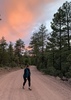
| no partners | | Well, initially we were planning on hiking the Newman peak, but knowing my wife, I had a "plan B" in the pocket just in case. We did have trouble getting to the trailhead; we took the E. Houser/Bradly Pump Road route, but when you have to turn off the main road(paved) since there is a gate to continue on the dirt road, shortly after there is a bit of a drop, and my wife stated that we were NOT going down that! She is a bit overly conservative when it comes to off road driving, and off route hiking.. I think the initial road may have been washed out a bit since the last reports of the road condition, so I wouldn't try it in any car, maybe a truck... We were in our 4WD 4Runner, so I know we could have made it, but not interested in making her mad.. Just happy she is willing to hike with me on the reasonable hikes, so we decided to do the Petroglyph sites. I had purchased the permit ahead of time in preparation.
Drive to the sites is reasonable, but it is sandy in some places; we never needed the 4WD, but it's important to keep a good speed (20-25mph) through the sandy sections so you don't loose momentum; especially in a normal car.
Enjoyed the walk about, and exploring the petroglyphs. Just posting the better ones here. If you want all 59 photos, you can go to my webpage:
https://www.artcentrics.com/08_Hiking/B ... _Sites.htm |
| _____________________
| | |
|
|
|
 Route Editor


](https://hikearizona.com/dex2/images/smilies/eusa_wall.gif "Brick wall") . The State Land Permits are available online now, so all you have to do is pay and print out your own permit (
. The State Land Permits are available online now, so all you have to do is pay and print out your own permit (