|
| | | Babe Haught to Aspen Spring, AZ | | | |
|
|
Babe Haught to Aspen Spring, AZ
| | |
| |
|
| Hiking | 34.50 Miles |
314 AEG |
| | Hiking | 34.50 Miles | 11 Hrs 45 Mns | | 2.94 mph |
| 314 ft AEG | | | | |
|
|
| |
| Linked |
|
none
[ show ]
| no linked trail guides |
| Partners |
|
none
[ show ]
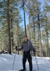
| no partners | | Solo day hike to Aspen Spring from Babe Haught Trail. Needed to do a long hike in preparation for upcoming PCT Section C that I want to do in May. Left from Fish Hatchery via Babe Haught. Then went off trail for about 1 mile west to meet up with FR300 (if I would have taken Babe Haught all the way to FR300 and then backtracked, it would have been 2.5 miles), this saved me 1.5 miles each way. Took FR300 to FR145, then Barbershop Trail to FR139, then FR139 to FR139A (I actually went past it because the sign was broken and on the ground; I leaned it up against a tree; this added an extra 2.4 miles roundtrip). From 139A, took Houston Brothers to Aspen Spring. Left at 5:20 am from parking lot, didn't stop a single time except to take pictures and videos. Got to Aspen Spring at 11:45 am.
There is some very minor snow still on rim, FRs that I hiked were completely clear. There were six vehicles on FR300 so it appears that FR300 is now open. Barbershop Trail (the 1.0 mile section that I hiked) had one short section of snow. Barbershop Canyon still has snow and the creek is running. There is probably enough snow where it should continue to melt for another 2 weeks is my best guess depending on temperatures. Houston Brothers Draw toward Aspen Spring is still flowing, but probably only for another 1-2 week or so, is my best guess since I didn't see as much snow as I did in Barbershop Canyon. But, that shouldn't be an issue since Aspen Spring (and Pinchot Spring) are reliable sources.
After eating a quick lunch (20 min max), I needed to head back. There were some dark clouds developing and I didn't want to get rained on. Luckily, it was just clouds. From noon until I finished at 5 pm, I did not see the sun at all. It was cool and windy for the remainder of the day. On the way back, I overshot my target (Babe Haught top of rim) by 0.5 miles, so that was another 1.0 bonus miles. The first 4 seasonal creeks from top of rim on Babe Haught trail 0.5 miles towards FR300 are now all dry.
Originally, I was estimating that my 31 mile trip would take 11-14 hours, but I made really good time since I never stopped to take a break except for lunch and it was cool hiking weather. Had I attempted this is warmer temperatures, I would have had to drink and carry a little more water than I did.
With the extra 3.5 miles, I still managed to finish in 11:45 hours, so I was very happy. I think my supported day hike of PCT Section C with daily mileages of 9, 32, 23, 25, 16, 15, and 12 is doable. |
| _____________________
| | |
|
|
|
 Route Editor