|
| | | Huayhuash circuit in Peru, WW | | | |
|
|
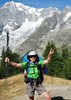
Huayhuash circuit in Peru, WW
| | |
| |
|
| Backpack | 83.00 Miles |
23,922 AEG |
| | Backpack | 83.00 Miles | 10 Days | | |
| 23,922 ft AEG | | | | |
|
|
| |
| Linked |
|
none
[ show ]
| no linked trail guides |
| Partners |
|
none
[ show ]
| no partners | | Huayhuash Circuit trekking in Peru on 7/5/17 to 7/15/17
I finally did this trek this month. It was on my list for over 10 years. I heard about it in 2006 from a young couple did it by backpacking and movie “Touching the void”. It was a very good experience for my life not just hiking in the high mountain region. From how to get to Lima, from airport to bus station then to Huaraz and to hostel to join the group. First I don’t speak any Spanish, second how to arrange all the trip smoothly. It was a big challenge for me. Spent a lot of time to prepare and arrange, Email and research to find right agency. Ok. I did it and finished it with good sole. Of course, I did not choose to backpacking for this 11 days trip by myself (I could not find any company wants to go with me). So I choose to hire local company to organize my whole trip. Spent some dollar to hire guide, cooker and donkeys to carry all my gear and cook for me too. So that is my first luxury trekking trip in my hiking history. Something is good like after long and hard hiking, the hot tea was ready for you, Tent was already set up for you and the hot dinner was waiting for you too. WOW, that was like a king on the trail. Not good about is you have to get up so early at 6:00am each morning due to they prefer hike early and get off early too even sometime we finished at noon. More not good about it you have to hiking someone you never met before. Some of them are not friendly at all. They are mean and rude. Especial when they know you are from United States. Said something are totally not true. Like American are fat. Hey, wait minutes, I am here I am not fat. I believe someone are overweight but that doesn’t mean everybody is fat in America. In your country, not everybody is skinny too. That is our neighbor from north of United States. In 11 days, you have to hiking, camping and eating with them together all the time. So I was not very happy under this situation. Instated, I will beat them each time when we climbed up to the hill or pass. Let them know “fat American” beat you. Even I am older and female. Whole trip, I treat them like invisible men. But they still will come to bother you. I am a vegetarian don’t eat meat then they will say I am picky. What is wrong with them? By the way, whole trip still is amazing for me. The view is fantastic. If you have watched the movie “Touching the Void”. You will know what I am talking about it. But this area in Peru is so remote, few people live there and less travelers. Their life is so simple and poor. Even I was grown up in China, been in a poor situation and worked in farm when I was young but after so many years they in Huaraz area are still much poorer. That is why I was happy to pay for camping fee to local to support them a little bit when we travel and crossed their land. The big surprise to me is they built flush toilets in almost each camping site and most of them are kept clean. I never find that in America and Europe. The whole trip is 83 miles long and total ascent 23922 feet, descent 24781 feet. Average camping at 14000 feet to 15000 feet elevation. The whole trip is not that long for what I did before. Just the elevation each day will trek between 14000 feet to 16900 feet. I had a problem to sleep started at third night and had very bad Diarrhea middle of trek. That caused my physical down very quickly and no time to recovery. I felt my energy level was at 60 to 70%. When we climbed the last pass on whole trip, I felt up the hill is so long and it last forever. Later I will post some of beautiful pictures. That is an awesome trip and the people in Huaraz area not in Lima (I did not stop in Lima only from airport to bus station) are so nice and kindly. My next goal is Nepal Annapurna circuit. I will not hire anyone to do this backpacking. Luckily I will have company to go with me this time. Cheer! |
| _____________________
| | |
|
|
|
 Route Editor