|
| | | |
| |
|
| Hiking | 11.70 Miles |
2,250 AEG |
| | Hiking | 11.70 Miles | 5 Hrs 37 Mns | | 2.63 mph |
| 2,250 ft AEG | 1 Hour 10 Mns Break | 10 LBS Pack | | |
|
|
| |
| Linked |
|
none
[ show ]
| no linked trail guides |
| Partners |
|
none
[ show ]
| no partners | | Set out this morning with the goal of a new personal longest hike. Got to Peralta just before 9... right in time to watch someone pull into the last spot in the main parking lot. D'oh! So off to the overflow lot I went.
Set out on the Dutchman... immediately encountered some Boy Scouts who had set out on the wrong trail and were turning around not 50 feet from the parking lot, then passed some leisure hikers, and then, once I was over that first ridge, sweet solitude. I enjoyed the portion on the Dutchman trail much more than I was expecting to: nice views, a decent number of wildflowers, pleasant rolling terrain that made a nice start to my planned 12 miles. Ran into a couple small groups of backpackers coming back from their overnight trip and one group of dayhikers who'd gotten an earlier start than me.
Next, I planned on taking the Coffee Flat trail for a little distance to get a better view of that unusual rock formation in the basin past Miners Needle (Hiker's Guide to the Superstitions calls it Cathedral Rock). I wasn't too impressed with the views or terrain on Coffee Flat, so I turned back after about half a mile.
And then... it happened. My first rattlesnake encounter. Unfortunately, it was a full-on rattling, "hey, I'm gonna bite you!" situation.  Let's just say that my pace substantially improved in the 30 seconds or so after that. Hey, I've been meaning to give trail running a try. Let's just say that my pace substantially improved in the 30 seconds or so after that. Hey, I've been meaning to give trail running a try.
The route up to Miners Saddle was uneventful, aside from the strengthening wind. Oh, and the garter snake that scared the bejeezus out of me after my earlier encounter. The north side of the ridge was a pleasant change, gentler everything: wind, terrain, plant life. Though all those grasses looked suspiciously like someplace a snake might hide... 
Little did I know that my encounters with venomous reptiles were not over! On the Bluff Spring trail, about halfway between the Terrapin junction and the turnoff point for Lower Barks Canyon, I came across a big ol' gila monster sunning himself in the middle of the trail. Surprised to see one here and in the early afternoon. I got some great photos as he ambled off into the grass. I didn't even shriek like a baby this time.
Met up with another group of day hikers that I'd been "racing" since Miners Saddle and hiked back to the parking lot in their company. Passed some folks going the other way that were loaded up with camping gear. Didn't you guys look at the forecast?!  Oh well, not my problem if you have to try to get down Bluff Springs trail in a thunderstorm tomorrow. Oh well, not my problem if you have to try to get down Bluff Springs trail in a thunderstorm tomorrow.
Happy with my distance accomplishment, but that rattlesnake encounter might mark the end of my Phoenix-area hiking adventures for the season. There's always Rim Country! |
|
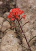
Wildflowers Observation Moderate
|
|
| _____________________
| | |
|
|
|
 Route Editor


 . Just enough time to run home and grab my boots and pack and get in a hike before sunset. I'd always wanted to do Siphon Draw, but the reported large crowds on the weekend scared me off. Not too many people out this late on a Friday afternoon, aside from some backpackers heading up to spend the night on the Flatiron. Turned around at the slick rock basin and made it back to my car right at sunset, taking ample photos along the way.
