|
| | | |
| |
|
| Backpack | 17.18 Miles |
3,986 AEG |
| | Backpack | 17.18 Miles | 2 Days | | |
| 3,986 ft AEG | | | | |
|
|
| |
| Linked |
|
none
[ show ]
| no linked trail guides |
| Partners |
|
none
[ show ]
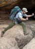
| no partners | | Led an overnight backpacking trip along the Mogollon Creek Trail with a group of 12.
The road in was fairly smooth, though one truck did inexplicably get a flat tire. There was no water flowing at the creek crossing a mile or two short of the trailhead. I wouldn't necessarily recommend it, but you could probably get a sedan to the trailhead. The road was completely fine for anything with high clearance. It should be noted that the official HAZ_Hikebot GPX track does not start at the trailhead and may not be accurate. I am not sure if there is a trail that matches the HAZ_Hikebot track.
Only 26 people had signed in at the trail register since the beginning of the year. Clearly the trail doesn't get much use. The first six miles of trail are largely uphill. This section of the trail was is in surprisingly good condition and shows evidence of recent trail maintenance. Due to the aforementioned flat tire issue, we got a later start than planned. While the temperatures were only in the 80s F, it was definitely hot and exposed. Near the top, there was a nice patch of woods that you could potentially camp in if you were willing to dry camp. Once you crest over the top, you pass through some burned areas and the condition of the trail declines. There are some downed trees to navigate, but nothing posed too much of an issue. The views from this side as you drop down toward Mogollon Creek are great. It's about a 2 mile decent down to the creek. The area along the creek is a bit overgrown. We lost the trail for a bit after reaching the creek, though we were able to follow it for the return trip. The views and scenery once you start dropping into the canyon are great. We camped for the night among the trees near the junction with Teepee Canyon.
Prior to the trip, I had called the Glenwood Ranger Station and the Gila National Monument to inquire about water availability. The rangers I talked to had no idea if the Mogollon Creek would be reliably flowing. I knew that the creek had an endemic Gila Trout population and had been restocked by the forest service, so I assumed it couldn't possibly entirely dry up. That turned out to be correct. It was flowing and there were pools of nice clear water along the section we hiked. There were some small fish that I assume were Gila Trout in the pools.
In the morning we got an early start to beat the heat and hiked out the way we came and back to the cars. Just north of Cliff, that same truck had yet another tire blow out. That resulted in an 8 hour ordeal involving two tow truck companies shuttling it across the state border to Safford where the nearest compatible tires (available on a Sunday) were found.
Overall it was a good trip. If I were to do it again, I would go earlier in the season. I would also try to make it a three day trip to allow for further exploration up canyon. The best scenery occurs after you crest over the top and start dropping into the canyon. I would have liked to have had more time to enjoy it. |
| _____________________
| | |
|
|
|
 Route Editor