|
| | | Simon Canyon and Navajo Lake State Park, NM | | | |
|
|
Simon Canyon and Navajo Lake State Park, NM
| | |
| |
|
| Hiking | 4.83 Miles |
161 AEG |
| | Hiking | 4.83 Miles | 2 Hrs 40 Mns | | 2.42 mph |
| 161 ft AEG | 40 Mns Break | | | |
|
|
| |
| Linked |
|
none
[ show ]
| no linked trail guides |
| Partners |
|
none
[ show ]
| no partners | | Simon Canyon is a small feature tucked in the Colorado Plateau landscape east of Farmington, New Mexico, not far from Navajo Dam, one of the largest reservoirs in the region. The area is dominated by a geology foundation of 50-30 million year old sandstones and shales laid down as the Rockies were rising skyward following the demise of the non-avian dinosaurs.
I arrived at the trailhead around 8:30 and was rather surprised by how well maintained it is. There are several covered picnic tables, trash receptacles, fire pits, and a vault toilet. When I arrived it seemed like most of the fellow site users were fisherman drawn to the San Juan for it's casting legacy. I'm not a fisherman myself so I really have nothing more on that subject.
From the trailhead, Simon Canyon is accessed by a single maintained 1.6 mile roundtrip trail leading to the northernmost of the Navajo "Pueblitos" that dot the landscape of the Dinetah, the ancestral homelands of the Navajo, aka Dine, people. These small stone masonry structures are perched on the walls of canyons and other defensible sites where it is said they provided shelter and protection during a time when the nearby Ute and Comanche Tribes were actively raiding their Dine neighbors as the result of stresses and other factors resulting from the encroachment of Spanish colonizers.
The trail starts from the trailhead following an oil-pad access road across the Simon wash and almost immediately climbing 120 feet up to a sandstone ledge on the canyon wall. The road ends at an active drill site, actively pumping oil (or more likely, natural gas) to the surface. From there, the trail diverges and moves along the ledge up the canyon, weaving through a wonderful Pinyon-Juniper woodland supporting some fun birds such as Ruby-crowned Kinglets, Juniper Titmice, Wrens, Swallows, and Swifts. The shrub layer is dominated by Utah Serviceberry, Yucca, Prickly Pear, Rabbitbrush, Ephedra, Cliffrose, and Fendlerbush. Wildflowers along the way included Primrose and Paintbrush, along with some very-close-to-blooming Ragworts and a handful of others. The Fendlerbush and Serviceberries were in full bloom, probably even past peak.
Springs along the canyon bottom support a nice gallery forest of Cottonwoods, Willows, and other riparian plants. The invasive hellscape of Russian Olive, Tamarisk, and Cheatgrass suffocating the riparian border of the San Juan river has not quite reached it's pestilence into this xeric ravine. We'll discuss that more in detail later. As Cottonwoods are one of the most important trees to native birds of the Southwestern United States, it was no surprise that it was teeming with activity. I saw and heard Coopers Hawks, Finches, Robins, Vireos, Towhees, Sparrows, and many others.
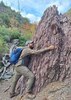
The pueblito of Simon Canyon itself is perched on a high 25 foot boulder with viewing slats facing down canyon and the door facing north. Hand and footholds are cut into the boulder for access from the east. And I was pleasantly surprised to find a nicely done interpretive panel at the base of the boulder that has somehow survived the decades without getting obliterated with grafitti and other vandalism like many other blm/public land sites. I hung around for about 40 minutes wandering around watching the bird activity and sipping on water before heading back down the trail.
Instead of returning straight to the car, I decided to go down the North San Juan River Trail. Unlike the seemingly healthy vegetation occupying Simon Canyon, the Cottonwood gallery the trail passes through at the beginning rapidly thins and declines in health, with most of the cottonwoods appearing half-dead, and the undergrowth of natives like Privet and Sagebrush giving way to Tamarisk and Russian Olive. What little natives persist are fighting for survival, and in the sunnier spots, there is an absolute blanket of Cheatgrass. Quite frankly. This trail gave me the "ick" and I won't return or recommend it for fellow hikers. It'd probably be more worth it to continue past the end of the official trail at Simon Canyon and explore upcanyon, searching for other hidden sites or natural arches which are quite prolific in the sandstone formations of the area.
I followed the North San Juan River Trail to the end, and after about a quarter mile it seems to be mostly used as fishing access. There was about a half dozen fisherman utilizing the river both on foot and in boats. I will have to return to the area to check out the dam itself another day. But for now, my adventure ended there. |
|
Wildflowers Observation Moderate
|
|
| | |
|
|
|
 Route Editor